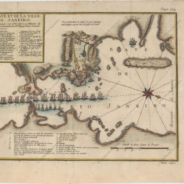
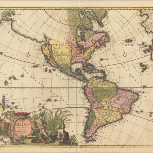
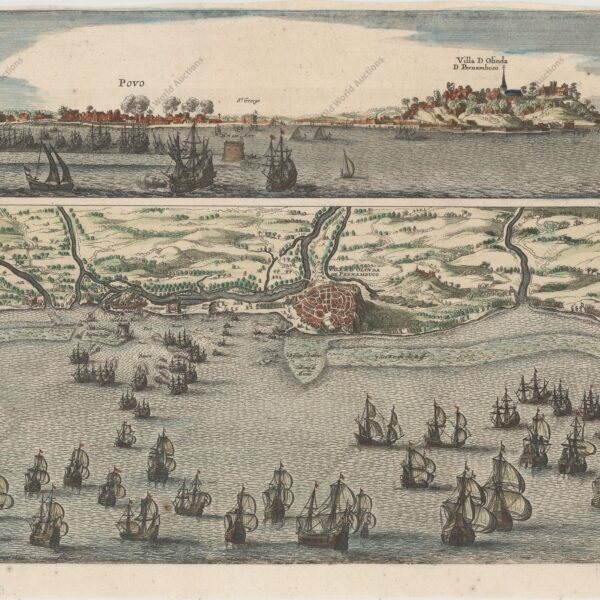
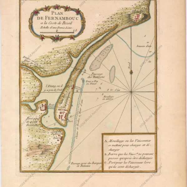
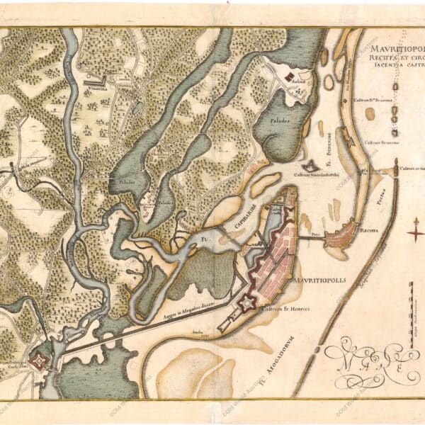
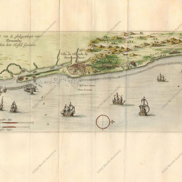
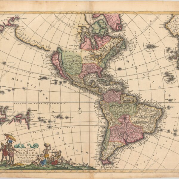
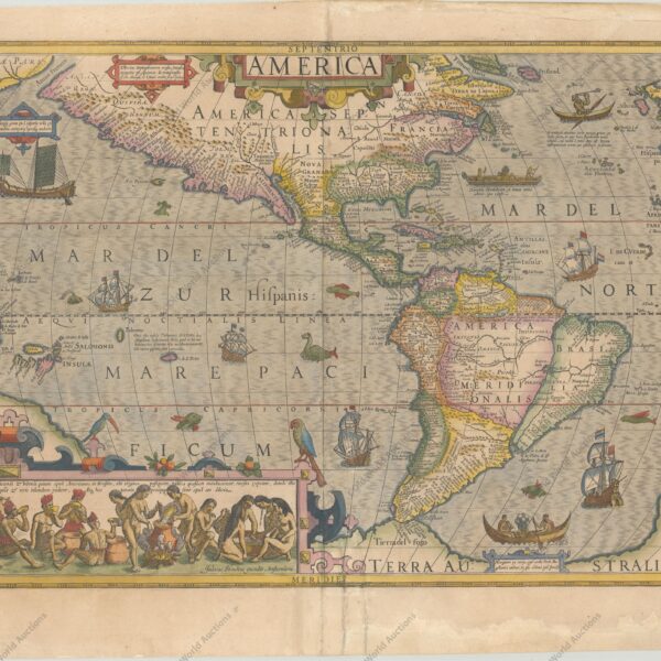
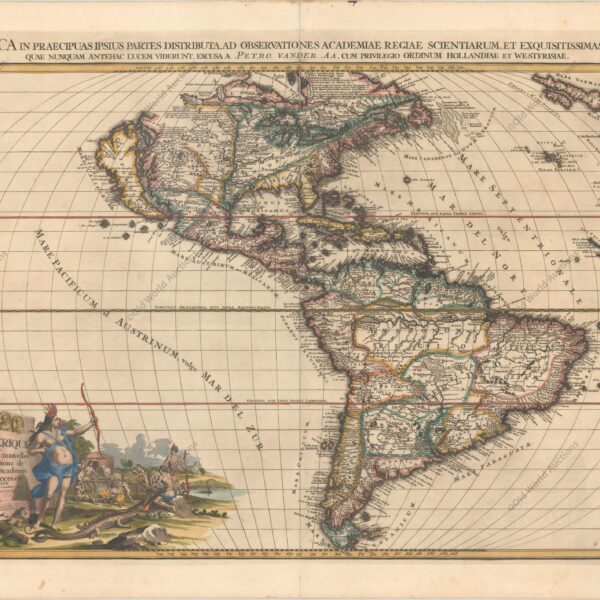
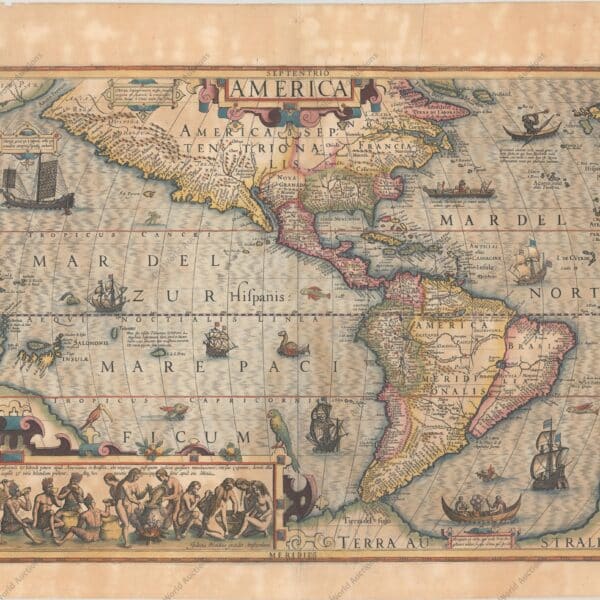
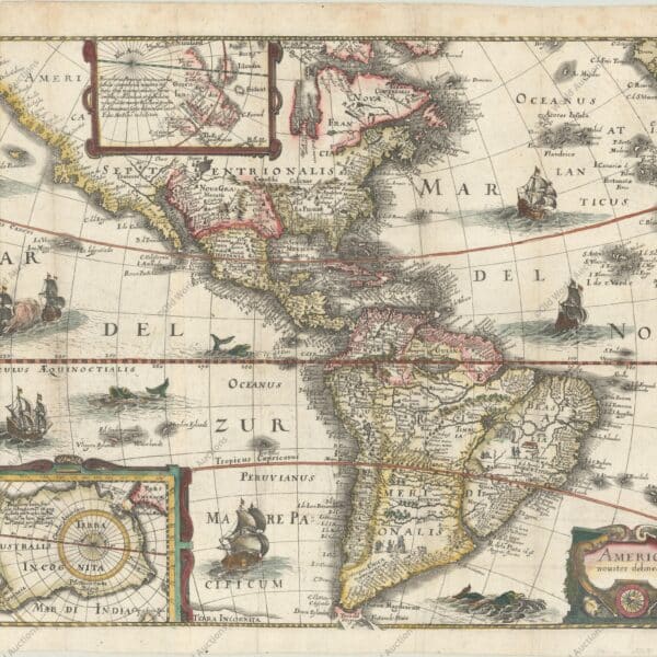
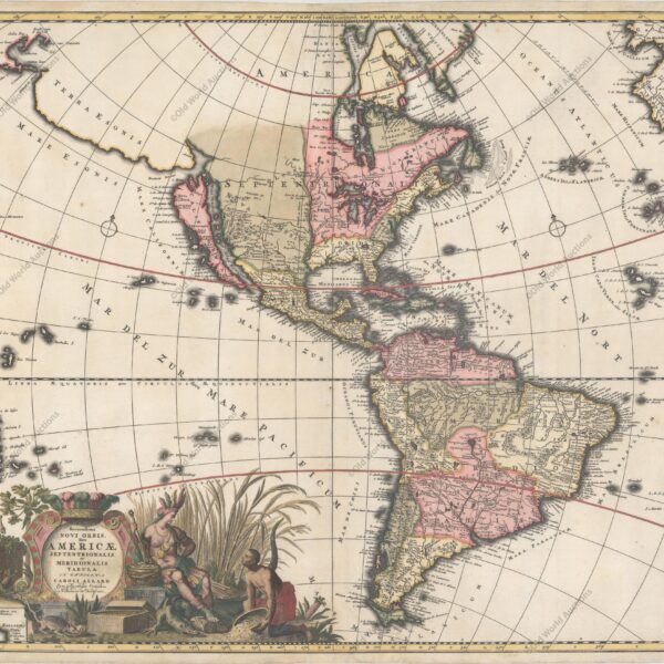
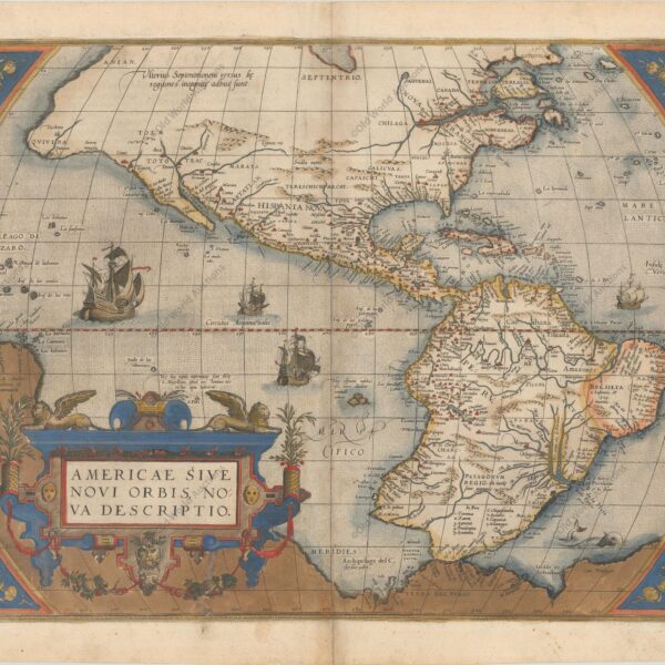
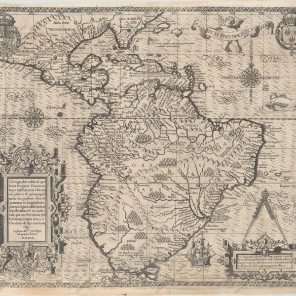
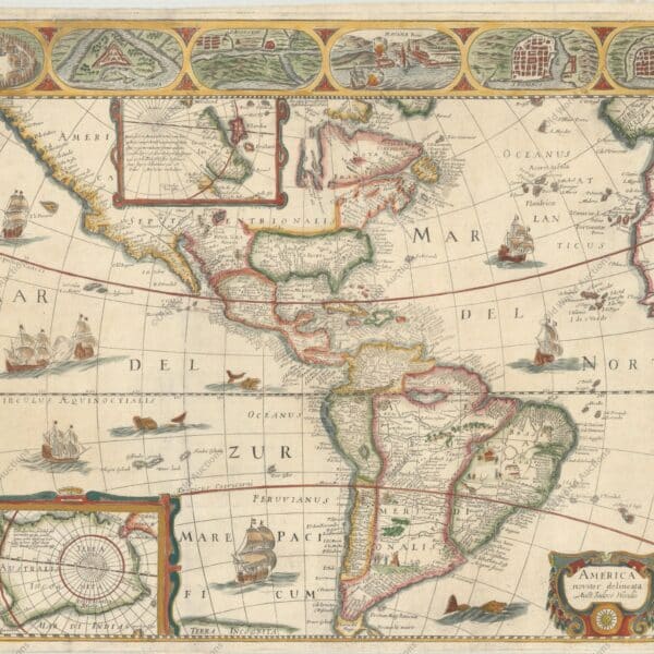
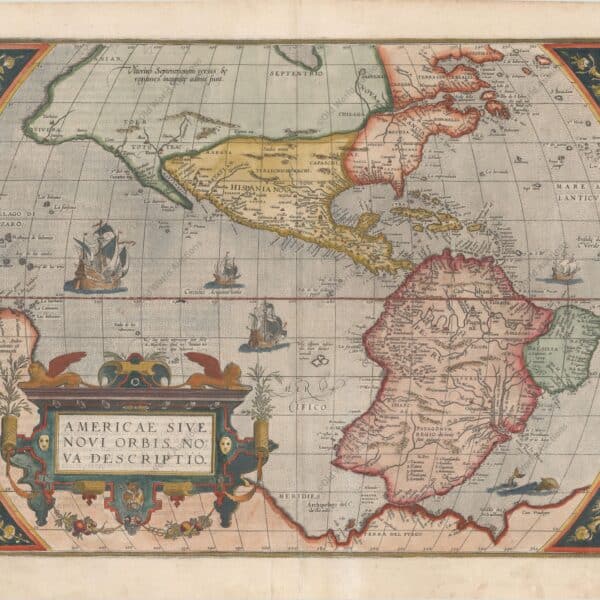
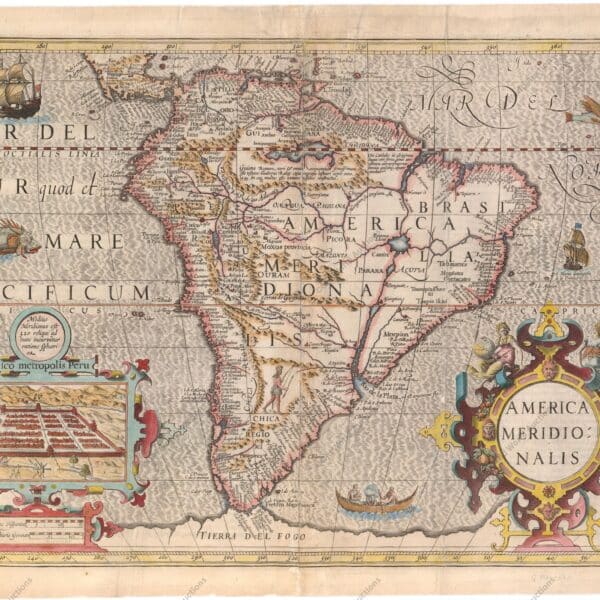
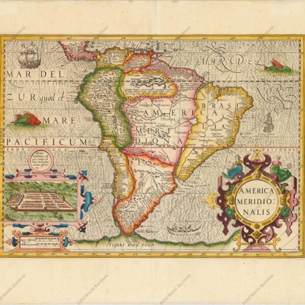
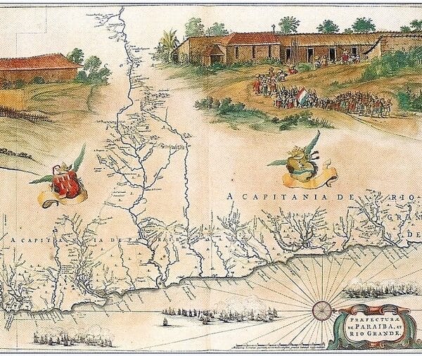
Map of the Western Hemisphere of 1607 – America Mercator’s foundation map of America “America sive India Nova, ad Magnae Gerardi Mercatoris aui Universalis Imitationem in Compendium Redacta”, Mercator, Michael This is one of the most famous maps of the Americas and an important base map for a collection of […]
Posts — Travel Guides and Tips for the Northeast and Brazil | Bahia.ws
1579 Map of the Western Hemisphere – America – Historical Map
1579 Map of the Western Hemisphere – America – Theatrum Orbis Terrarum Ortelius’ Influential Map of the New World – Second Plate in Contemporary Colour “Americae sive Novi Orbis, Nova Descriptio”, Ortelius, Abraham This is one of the most famous maps of America, which had an enormous influence on the […]
Jean-Baptiste Debret: biography and works in Brazil
Jean-Baptiste Debret (1768-1848) was a renowned French painter, draughtsman and lithographer, known for his significant contribution to the art and historical documentation of Brazil in the 19th century. A graduate of the Paris Academy of Fine Arts and a disciple of Jacques-Louis David, he initially stood out for his works […]
Map of Southern South America, 1668 – Historical Map
Map of southern South America of 1668 – Cartes Generales de Toutes les Parties du Monde… “La Terre et les Isles Magellaniques Tirees des Relations les Plus Recentes”, Sanson/Mariette An unusual map of Patagonia, southern Chile and Tierra del Fuego. Buenos Aires and the mouth of the River Plate are […]
History of Baroque Architecture in the Northeast and Minas Gerais
Baroque architecture is an important part of Western history, with unique characteristics that shaped the urbanisation of Europe and can still be seen in Brazil today. Although the first signs of Baroque architecture can be found in works from the early 16^(th) century, it was only towards the end of […]
Map of Rio de Janeiro, 1794 – Historical Map
Map of Rio de Janeiro, 1794 “Plan of the Bay and Harbour of Rio-janeiro on the Coast of Brazil”, Laurie & Whittle This rare plan of Rio de Janeiro is based on the work of D’Apres de Mannevillette, with improvements by Sampson Hall, first mate of the Royal Bishop, and […]
Map of Brazil 1698 – Historical Map
Map of Brazil from 1698 – Istoria delle Guerre del Regno del Brasile “Itamaraca, Brazil”, Horatius, Andreas Antonius This magnificent map of the Brazilian province of Itamaraca, including part of Paraíba, was one of the 23 maps in this rare account of the Dutch-Portuguese colonial war. Written by João José […]
Map of Rio de Janeiro from 1682 – Historical Map
Map of Rio de Janeiro 1682 “Pas-kaart, Van de Zee-Kusten van, Brazilia, Tusschen, C.S. Thome en I.S. Catharina…”, Keulen, Johannes van Rare sea chart of the Brazilian coast from the island of Santa Catarina to Cape S. Thomé. Thomé, together with an inset of the Rio Ianeiro (Rio de Janeiro […]
Map of Rio de Janeiro of 1810 – Historical Map
Map of Rio de Janeiro of 1810 “Esquisse de la Ville et du Port de Rio De Janeiro”, Tardieu, Pierre Francois This rare aerial view of Rio de Janeiro shows forts, batteries and landing places for ships. Soundings, anchorages, sandbanks and navigational hazards are shown. A note in the lower […]
Map of Rio de Janeiro of 1764 – Historical Map
Map of Rio de Janeiro of 1764 “Plan de la Baye de Rio-janeiro”, Bellin, Jacques Nicolas This beautiful map shows the Guanabara Bay with an aerial view of Rio de Janeiro. The decorative title cartouche contains a lettered legend identifying 12 locations in the bay, including 6 forts. Guanabara Bay […]
Map of Rio de Janeiro, 1750 – Historical Map
Map of Rio de Janeiro of 1750 “Plan de la Baye et de la Ville de Rio Janeiro…” This beautiful panoramic plan of Rio de Janeiro and Guanabara Bay was created to illustrate the French siege of 1711. A large compass rose points north to right. Numbered and lettered legends […]
Map of Rio de Janeiro, 1840 – Historical Map
Map of Rio de Janeiro from 1840 – Abrege de Geographie… “Rio de Janeiro”, Renouard, Jules This sheet shows a detailed grid plan of Rio de Janeiro. The topography of the surrounding area is well represented. Drawn by A.H. Dufour, engraved by Desbuissons and lettered by Benard. Map of Rio […]
Map of Rio de Janeiro, 1775 – Historical Map
Map of Rio de Janeiro from 1775 – Le Neptune Oriental “Plan de la Baye et du Port de Rio-janeiro…”, Apres de Mannevillette, Jean B. N. D. This important old harbour chart shows Rio de Janeiro in block plan form. All the islands and coastal features are shown, with many […]
Popular Art from the Northeast of Brazil
Popular art from the Northeast of Brazil reflects the vastness of its territory and the diversity of its culture, and some types of work can be found, with slight variations, in all the states. While relying on tradition, popular art of the Northeast discovers new languages, techniques and materials: the […]
History, biography and paintings of Frans Post in Dutch Brazil
The representation of Brazil through European eyes in the 17th century From the 16th century, conquerors began to interpret South America not only through words, but also through images. This process of visual representation gained momentum with the Dutch invasion of northeastern Brazil between 1630 and 1654, when European artists […]
History and Chronology of the Portuguese Tile Industry
The art of tiling would take root in the Iberian Peninsula under the influence of the Arabs, who brought the unknown mosaics to their conquered lands to decorate the walls of their palaces, making them shine and shine with a complex play of geometries. The style fascinated the Spaniards and […]
Map of the Western Hemisphere from 1700 – Historical Map
Map of the Western Hemisphere, 1700 This sumptuous map of the Americas features a dramatically decorative title cartouche depicting an Amazon queen surrounded by riches, a sugar cane field and exotic animals. Inserted in the cartouche is a small map of the coast of New Zealand. The cartography of North […]
1719 Historical Map of the Western Hemisphere
Map of the Western Hemisphere, 1719 This spectacular wall map is richly engraved in the tradition of Dutch cartography. Although the main focus of the map is the Americas, it also covers the entire Pacific, including the East Indies and Japan, and the entire Atlantic, including much of Western Europe […]
1730 Historical Map of the Western Hemisphere
Map of the Western Hemisphere, 1730 This attractive map is a revision of old Homann’s 1710 map of America. After his death in 1724, his son (Johann Christoph Homann) re-engraved the plate to correct the west coast of North America, which here extends far to the west and north, with […]
1740 Map of the Western Hemisphere – Historical Map
Map of the Western Hemisphere, 1740 This impressive map of the Americas shows a prominent island of California, based on the second Sanson model, with two jagged bays on its north coast. Just above the island is the Strait of Fretum Anian and the coastline of Terra Esonis incognito, obscured […]
1638 Map of South America – Historical Map
Map of South America from 1638 This is an important decorative map of the continent and an essential piece for any South American collection. The coastlines are well detailed, but the interior is full of misinformation. Several rivers (including the Amazon and the Paraguay) flow into the Lago de los […]
1694 Map of South America – Historical Map
Map of South America from 1694 This beautiful map of the continent is decorated with elaborate title and mileage cartouches, which balance the lower part of the map with images of Native Americans, flora and fauna. One cartouche contains the title of the map, while the other shows eight different […]
1730 Map of Northern South America – Historical Map
Map of Northern South America from 1730 This beautiful and important map of the northern part of South America is full of information and annotations speculating on the indigenous tribes and the tributaries of the Amazon. The captains are shown along the coast of Brazil. An annotation in Guyana records […]
History and architecture of the Palácio do Campo das Princesas in Recife
The Campo das Princesas Palace, the seat of government of the state of Pernambuco, was built in 1841, originally in the neoclassical style. Over time, however, the building underwent several reconstructions and extensions, incorporating elements characteristic of architectural eclecticism. Neoclassicism was a artistic and literary movement that emerged in the […]
Franciscans in Brazil: Urban, architectural and artistic heritage
The Franciscan presence in Brazil can be traced back to the Discovery, when Friar Henry of Coimbra, a member of the Cabral’s Expedition, celebrated the First Mass on 22 April 1500, shortly after arriving at the bay of Port Seguro, in the south of what is now the state of […]
São Francisco Cultural Centre: A Baroque Marvel
The São Francisco Cultural Centre, located in the Historic Centre of João Pessoa, Paraíba, is one of the most important historical and cultural landmarks of the city. This architectural complex is a significant example of Baroque art in Brazil and includes the Church of São Francisco and the Convent of […]
Giant Puppets and Their Role in Olinda Carnival
The Olinda Carnival in Pernambuco is an important cultural event in the Brazilian scene, characterised by the rhythm of frevo, popular expressions and the presence of giant puppets. The giant puppets were introduced in 1932 with the Midnight Man, and these papier-mâché visual elements have become icons of local cultural […]
Graça Church and Olinda Seminary Historical Significance
The city of Olinda, in Pernambuco, is home to one of the most important landmarks in the religious and educational history of colonial Brazil: the Church of Nossa Senhora da Graça and the Seminary of Olinda. This religious complex dates back to the 16th century and is of great historical […]
Monastery of São Bento de Olinda: A Historic Landmark
São Bento de Olinda Monastery: History, Architecture and Cultural Importance The Monastery of São Bento de Olinda, located in the state of Pernambuco, is one of the most important monuments of the historical, religious and artistic heritage of colonial Brazil. Founded in the context of the Benedictine expansion in the […]
Olinda Cathedral: A Historical Landmark in Brazil
Olinda Cathedral: History and Architecture The Olinda Cathedral, also known as the Church of Saint Saviour of the World, is located in the Historic Site of Olinda and occupies a prominent position in the city’s landscape. As well as being the first religious building constructed by the Portuguese on their […]
Birds Found in Chapada Diamantina: A Guide
According to data published in 1999, there are 359 bird species in the Chapada Diamantina. Among them are species endemic to different Brazilian biomes and 21 species threatened with extinction. The Chapada Diamantina is known for its beautiful natural landscapes, and when it comes to birds, the Chapada is home […]
Franciscan Monastery of Olinda: A Historic Landmark
Although they had been present in Brazil since the first Portuguese expeditions, the Franciscans did not settle here permanently until several decades later. In this respect, the Franciscan Monastery of Olinda is considered the oldest establishment of the disciples of St Francis on Brazilian soil, the cradle of the Order […]
Main Towns and Villages in the Chapada Diamantina Region
Chapada Diamantina, a region in the heart of Bahia, is home to a 152,000-hectare national park that preserves hundreds of waterfalls, archaeological sites and magnificent geology. The scenic beauty of the Chapada Diamantina National Park is enjoyed by locals and tourists alike – it is an area of vast geological […]
Solar do Unhão & MAM-BA — History, Architecture and a Visit
The history and architecture of Solar do Unhão Solar do Unhão is a historic architectural complex situated on the shores of Todos os Santos Bay in Salvador (BA). Dating from the 17th and 18th centuries, the complex comprises the main manor house, the Chapel of Nossa Senhora da Conceição, a […]
Tourist attractions in the Gamboa neighbourhood in Salvador BA
The Gamboa neighbourhood: one of the best places to visit in Salvador The Gamboa neighbourhood in Salvador is characterised by being a coastal community, which has been inhabited by fishermen for centuries, situated at the south-western entrance to the Bay of Todos os Santos, close to the historic city centre. […]
History and sights of Avenida Contorno in Salvador BA
Avenida Contorno in Salvador (also known as Avenida Lafayette Coutinho) is one of the most iconic stretches of the city’s waterfront, linking Cidade Alta to Cidade Baixa and running alongside the Bay of Todos-os-Santos.In this guide, you’ll find a historical overview and the main tourist attractions along the avenue. A […]
Map of Olinda in Pernambuco from 1640 – Historical Map
Map of Olinda in Pernambuco from 1640 This map shows two views of the Portuguese sugar colonies in Brazil during the Dutch invasion in 1630. The top view shows the Dutch fleet attacking the port and fort. Below is a plan of the town of Olinda and its surroundings, with […]
Jade stone – characteristics, colour, classification and cutting
Jade is a mineral that has been used since prehistoric times. Because of its hardness, it was valued for making weapons and instruments. In China, it was used in the manufacture of religious figures and symbols used in the worship of the gods. In pre-Columbian Central America, jade was more […]
Agate Stone – Characteristics, Types, Colour and Cutting
Agate has always been prized, from ancient times by the Egyptians and Sumerians. According to various beliefs, it has the power to energise the wearer and promote healing. Like all gemstones, it is attributed with various powers and mystical properties. However, it is a gemstone that is characterised by its […]
Amethyst stone – characteristics, marketing and valuation
Considered the most striking of the quartz family, amethyst has always been coveted. Queen Catherine the Great was a great admirer of this gemstone. For a long time it was considered as precious as sapphires, diamonds and emeralds. Today, with the discovery of abundant deposits, it is no longer as […]
Maritime chart of the east coast of Brazil Ilha Grande and Sapetiba Bay 1884
Marine Map of the East Coast of Brazil Ilha Grande and Sapetiba Bay 1884 Beautiful large scale chart of the region west of Rio de Janeiro. Complete with soundings, anchorages and navigational hazards. In the background is a view of Ilha Grande and the East Passage. The chart was first […]
1823 Map of Brazil – Historical Map
Map of Brazil from 1823 A detailed map of Brazil showing cities, regions, mountains and the extensive river system. Lucas’ General Atlas is considered one of the finest general atlases produced in the USA at the time, due to its high quality paper, excellent engraving and attractive colouring. It was […]
1832 Map of Brazil – Historical Map
Map of Brazil from 1832 Cities, rivers, natives and more. English, Dutch and French Guiana appear to the north of Brazil. Parts of Colombia, Bolivia and Argentina are shown in less detail, and Paraguay and Uruguay are shown as part of Brazil.
Historical maps showing the territorial development of Brazil
The Territorial Formation of Brazil: From Continental Archipelago to National Unity Historical maps and the formation of Brazil Historical Maps show the development and territorial expansion of Brazil and the Western Hemisphere from Discovery to Independence. Learn about the historical facts that led to Brazil’s emergence from a continental archipelago. […]
Tiger Eye Stone – Characteristics and Cutting
The Arabs and ancient Greeks believed that the Tiger’s Eye gave clarity of thought, activated personal power and integrated the spirit with the energy of the earth. This uniquely beautiful gemstone is still widely used today to promote spiritual and mystical benefits. In jewellery, the stone’s beauty and mystery are […]
Engraving of Fort Nassau in Pernambuco, 1671
Engraving of Fort Nassau in Pernambuco, 1671 Montanus’ work was perhaps the largest illustrated book on the New World produced in the 17th century. It contained more than one hundred beautifully engraved plates, views and maps of North and South America. The plates vividly depicted forts, festivals, occupations, Dutch fleets, […]
Map of South America and Brazil 1624 – Historical Map
Map of South America and Brazil, 1624 This engraving is part of a remarkable series of publications illustrating voyages of discovery and exploration in different parts of the world. The project was begun by Theodore de Bry of Frankfurt in 1590 and was to continue for another 54 years. Together […]
Map of the Captaincy of Pernambuco and Ceará from 1680
Map of the Captaincies of Pernambuco and Ceará from 1680 This rare map of the captaincies of Ceará and Pernambuco stretches from the Formosa River to the Estremo River, with the São Francisco River at its centre. Much of the information is derived from maps drawn for the Dutch West […]
Engraving of Vila de Olinda in 1671 – Historical Engraving
Engraving of Olinda, 1671 These splendid views illustrate the Dutch attack on the Portuguese town of Olinda in 1630. For most of the 17th century, Portugal and the Netherlands had a trade agreement whereby the Portuguese colonies in the New World produced sugar and the Dutch distributed it throughout Europe […]
Map of Recife of 1764 – Historical Map
Map of Recife – Brazil – circa 1764 – Publication: Le Petit Atlas Maritime… Volume 2 No. 50 “Plan de Fernambouc a la Coste de Bresil”, Bellin, Jacques Nicolas This fine chart shows the area around Recife (Pernambuco) extending northwards to Olinda. Depth soundings, anchorages and rocks are shown, together […]
1679 Map of Recife – Historical Map
Map of Recife from 1679 A rare aerial map of the city of Recife and its surroundings, showing the Dutch fortifications. Although originally founded by the Portuguese, the Dutch decided to invade several cities in Pernambuco because of the local sugar cane industry. From 1630 to 1654, the Dutch controlled […]
Engraving of the town of Olinda in 1633 – Historical Engraving
Engraving of the town of Olinda, 1633 This is a rare and fascinating aerial view of Olinda and the coast of Pernambuco, based on the work of Hessel Gerritsz, who is credited in the title. It illustrates the attack and capture of the Portuguese settlement of Olinda by a Dutch […]
Map of the Bay of All Saints and Pernambuco, 1700
Map of Baia de Todos os Santos and Pernambuco from 1700 This beautiful decorative map of Brazil is oriented with north to the right. Two insets show Dutch interests in the area (Baia de Todos os Santos and Pernambuco). The interior is largely devoid of geographical information, instead depicting scenes […]
1587 Historical Map of the Western Hemisphere
Map of the Western Hemisphere, 1587 This is one of the most famous maps of the Americas, and one that had an enormous influence on the future cartography of the New World. It was engraved by Frans Hogenberg and is based largely on Gerard Mercator’s large multi-sheet world map of […]
1628 Historical Map of the Western Hemisphere
Map of the Western Hemisphere, 1628 Jodocus Hondius’ map of the Americas is one of the most elaborate examples of fine Dutch cartography. The decorations, including sea monsters, native birds, native canoes and sailing ships, were taken from De Bry’s Grand Voyages. Particularly noteworthy is the scene of the natives […]
1643 Map of the Western Hemisphere – Historical Map
Map of the Western Hemisphere 1643 This impressive carte-a-figure map is an excellent example of the fine art of decorative cartography and a 17th century European view of the New World. The coastal contours generally follow Ortelius and Wytfliet, with the nomenclature of various explorers and settlers. The side panels, […]
1677 Map of the Western Hemisphere – Historical Map
Map of the Western Hemisphere, 1677 Visscher’s map greatly influenced the cartography of the Americas, both geographically and artistically. One of the most striking geographical details copied by other cartographers is the large open lake in the Great Lakes region. In fact, Visscher copied this from Blaeu’s wall map mundi […]
1727 Map of the Western Hemisphere – Historical Map
Map of the Western Hemisphere, 1727 This beautiful map of the Americas is an interesting version of the map series inspired by Nicolas Visscher in 1658. This map was first published by Justus Danckerts around 1696, but the plate was sold by the family to Reiner and Josua Ottens after […]
1628 Map of the Western Hemisphere – Historical Map
Map of the Western Hemisphere, 1628 Jodocus Hondius’ map of the Americas is one of the most elaborate examples of fine Dutch cartography. The decorations, including sea monsters, native birds, native canoes and sailing ships, were taken from De Bry’s Grand Voyages. Particularly noteworthy is the scene of the natives […]
Tiles from São Luís do Maranhão: History, Art and Heritage
The Facade Tiles of São Luís do Maranhão are symbols of the Luso-Brazilian heritage, combining aesthetic function and climate protection. They originated in Portugal in the 19th century and reflect Renaissance, Mannerist and Industrial styles. Present in thousands of buildings, they are part of the city’s historical heritage, recognised by […]
Sapphire is the purity of nature and a symbol of honesty
The sapphire stone was known to the ancient Egyptians as ‘the stone of the stars’. They believed that sapphire stimulated honesty, truth and justice. Whatever its properties and “powers”, the colour and purity of this stone, as coveted and prized as the diamond, arouse the desire and interest of jewellery […]
1713 Map of the Western Hemisphere – Historical Map
1713 Map of the Western Hemisphere A highly decorative and detailed map of the Americas, with the island of California prominently featured in the second Sanson model, with a heavily indented northern coast. The British colonies are limited to the east coast by Les Cinq Nationals Iroquoises, while the French […]
Jewellery made from different types of coral – Features
Its colour and rarity have long given coral the status of a precious stone. Recently, however, the gemological use of coral has been questioned due to its environmental impact and the fact that it is a marine animal. According to some, there is misinformation about this aspect. Corals literally form […]
Characteristics of the Paraíba Tourmaline, a rare gemstone
Paraíba Tourmaline was first discovered in Brazil in the 1980s, in the São José da Batalha region – hence its name – then in Nigeria in 2000 and later in Mozambique in 2004. Some 600 million years ago, a unique geological event created the most spectacular variety of gemstone in […]
Diamonds have 4 basic classifications, weight, colour, purity and cut
Before we find out how to identify a real diamond, let’s learn a little more about this special stone. The word diamond comes from the Greek adamas, meaning “indestructible”, and the first versions were formed over 2.5 billion years ago. Sought after by many, it is one of the world’s […]
1609 Map of the Western Hemisphere – Historical Map
Map of the Western Hemisphere, 1609 Jodocus Hondius’ map of the Americas is one of the most elaborate examples of fine Dutch cartography. The decorations, including sea monsters, native birds, native canoes and sailing ships, were taken from De Bry’s Grand Voyages. Particularly noteworthy is the scene of the natives […]
1714 Map of the Western Hemisphere – Historical Map
Map of the Western Hemisphere, 1714 Van der Aa’s unusual map of America was first published in 1714 and contains interesting geographical myths. In North America, California is shown as an island at the beginning of the Sanson shape, with an almost flat top starting at C. Mendocina. New Albion […]
1550 Map of the Western Hemisphere – Historical Map
Map of the Western Hemisphere, 1550 Sebastian Munster (1489 – 1552) was one of the three most famous cartographers of the 16th century, along with Mercator and Ortelius. Munster’s Geographia and Cosmographia Universalis were two of the most widely read and influential books of the time. His editions of Ptolemy’s […]
1660 Map of the Western Hemisphere – Historical Map
1660 Map of the Western Hemisphere An unusual and splendid figurative map of the Americas. The map combines many different sources, including Luke Foxe’s model of the island of California. The only hint of the Great Lakes is a small L. Content at the end of the St Lawrence River. […]
1587 Map of the Western Hemisphere – Historical Map
Map of the Western Hemisphere, 1587 This is one of the most famous maps of the Americas, and one that had an enormous influence on the future cartography of the New World. It was engraved by Frans Hogenberg and is largely based on Gerard Mercator’s large multi-sheet world map of […]
1631 Map of the Western Hemisphere – Historical Map
Map of the Western Hemisphere, 1631 This is the unusual and larger version of Merian’s map of the Americas. Merian’s bold engraving style copies the cartography of Jodocus Hondius’ 1631 map. North America is depicted with a prominent Virginia and an odd New England coastline. The west coast above California […]
1744 Map of the Western Hemisphere – Historical Map
Map of the Western Hemisphere, 1744 This attractive map is a revision of old Homann’s 1710 map of America. After his death in 1724, his son (Johann Christoph Homann) re-engraved the plate to correct the west coast of North America, which here extends far to the west and north, with […]
1719 Map of the Western Hemisphere – Historical Map
Map of the Western Hemisphere, 1719 This spectacular wall map is richly engraved in the tradition of Dutch cartography. Although the main focus of the map is the Americas, it also covers the entire Pacific, including the East Indies and Japan, and the entire Atlantic, including much of Western Europe […]
1730 Map of the Western Hemisphere – Historical Map
Map of the Western Hemisphere, 1730 This attractive map is a revision of old Homann’s 1710 map of America. After his death in 1724, his son (Johann Christoph Homann) re-engraved the plate to correct the west coast of North America, which here extends far to the west and north, with […]
1697 Map of the Western Hemisphere – Historical Map
1697 Map of the Western Hemisphere This sumptuous map of the Americas features a dramatically decorative title cartouche depicting an Amazon queen surrounded by riches, a sugar cane field and exotic animals. Inserted in the cartouche is a small map of the coast of New Zealand. The cartography of North […]
1579 Map of the Western Hemisphere – Historical Map
Map of the Western Hemisphere 1579 This is one of the most famous maps of the Americas, and one that had an enormous influence on future cartography of the New World. The map is largely based on Gerard Mercator’s large multi-sheet world map of 1569. The most recognisable features of […]
The malachite stone is a distinctive gemstone – Features
Thanks to its unmistakable colour and beauty, malachite is a gemstone often used by jewellery designers. Its irregular stripes and rings of varying shades of green give it a unique character and incredible versatility in both jewellery and costume jewellery. Because it’s an easy gem to find, it may not […]
Map of Brazil 1747 – Historical Map of Brazil
Map of Brazil from 1747 Copper engraved map with good detail along the coast with dozens of place names. The map covers the region between northern Paraguay and north to the mouth of the Amazon. A large inset of the island of Santa Catarina fills the empty ocean. In a […]
1592 Map of the Western Hemisphere – Historical Map
Map of the Western Hemisphere, 1592 This engraving is part of a remarkable series of publications illustrating voyages of discovery and exploration in different parts of the world. The project was begun by Theodore de Bry of Frankfurt in 1590 and was to continue for another 54 years. Together they […]
1623 Map of the Western Hemisphere – Historical Map
Map of the Western Hemisphere, 1659 This is a very rare derivative of the important Hondius map of 1618. The engraver is unknown, although it is closely copied from Picart’s version of 1644, which in turn was derived from Jansson’s map of 1623. North America retains the peninsula of California, […]
1581 Map of the Western Hemisphere – Historical Map
Map of the Western Hemisphere of 1581 This is one of the most famous maps of the Americas, and one that had an enormous influence on future cartography of the New World. The map is largely based on Gerard Mercator’s large multi-sheet world map of 1569. The most recognisable features […]
Tourmaline: Learn about its characteristics and varieties
Tourmaline is one of the most popular and favoured gemstones among jewellery designers, offering a wide variety of colours often found in a single stone. It easily adapts to fashion trends and can be combined with most metals. But you need to know a little more about the technical aspects […]
Identifying a gem is a difficult task
The variety of gems (precious stones) found in nature is a divine gift to us. Their colours and crystalline structures have enchanted us for thousands of years. And we jewellery professionals give them shapes and facets that enhance their brilliance and value when creatively applied to a piece of jewellery. […]
1659 Map of the Western Hemisphere – Historical Map
Map of the Western Hemisphere, 1659 This is a very rare derivative of the important Hondius map of 1618. The engraver is unknown, although it is a close copy of Picart’s version of 1644, which in turn was derived from Jansson’s map of 1623. North America retains the peninsula of […]
Map of the Brazilian Coast from 1678 – Historical Map of Brazil
Map of the Coast of Brazil from 1678 This splendid map of Brazil is mainly a nautical chart with details limited to the coastline. Oriented with north to the left by two fine points of the compass, it covers the Brazilian coast from the mouth of the Amazon to the […]
Map of eastern Brazil 1664 – Historical Map of Brazil
Map of Eastern Brazil 1664 This beautiful map of the Brazilian coast is richly decorated with a scene of natives with a watchtower and a huge fleet of ships. With north to the right, the map covers the coastal region from São Francisco to Recife. It was based on real […]
Map of South America from 1750 – Historical Maps of Brazil
Map of South America from 1750 Beautifully engraved Italian edition of Delisle’s map of South America, extending from Nicaragua to Tierra del Fuego. The place names of South America are mainly concentrated on the coasts and along the Amazon and Paraná rivers. There are also two mythical lakes: Lake Cassipa […]
Map of Brazil 1698 – Historical Maps of Brazil
Map of Brazil from 1698 This magnificent map of Brazil, including parts of neighbouring countries, was one of 23 maps in this rare account of the Portuguese-Dutch colonial war. Written by João José de Santa Teresa, known to bibliophiles as Saint Teresa, it is considered one of the most sumptuous […]
Map of Brazil from 1750 – Historical Map of Brazil
Map of Brazil from 1750 This is a beautiful Italian map of Brazil based on Delisle’s cartography. There is very good detail along the coast and a good amount of information about the interior with numerous annotations and locations of indigenous tribes. The map is decorated with a large pictorial […]
1639 Map of Paraíba – Historical Map of Brazil
Map of Paraíba from 1639 A splendid map of the Paraíba region and the defensive forts at the mouth of the Paraíba River. The map illustrates the Dutch invasion of Portuguese territory, showing the Dutch fleet filling the river and the defending armies marching along the roads. A large and […]
Map of Brazil divided into fourteen hereditary captainships from 1657 onwards
Map of Brazil divided into fourteen hereditary captaincies from 1657 onwards “Le Bresil, dont la Coste est Possedee par les Portugais, et Divisee en Quatorze Capitaineries…”, Sanson, Nicolas Map of Brazil divided into fourteen hereditary captaincies, 1657 – This is a reduced version of Sanson’s important map showing the Portuguese […]
Map of the Captaincy of Paraíba and Rio Grande, 1720
Map of the Captaincy of Paraíba and Rio Grande from 1720 Excellent map of the Brazilian coast, including the captaincies of Paraíba and Rio Grande. The map was drawn after real research by Georg Markgraf, Elias Herckmanns and others and was one of the first maps of Brazil based on […]
Map of All Saints Bay 1769 – Historical Maps
Map of the Bay of All Saints, 1769 This map is a boldly engraved graphic of the Bay of Salvador (Bahia) with an inset plan of the fortified city of Salvador. Navigational soundings and shoals are shown in the bay. Numerous plantations and sugar mills are marked with symbols along […]
All Saints Bay Map of 1644 – Historical Map
Map of the Bay of All Saints, 1644 This rare map of Salvador and the Bay of All Saints shows the Dutch attack and capture of the city of Salvador in May 1624. Salvador, then the capital of Brazil, was a strategic port under Portuguese control. The Dutch, determined to […]
Engraving of Cabo Santo Agostinho from 1645 – Historical Engravings
Engraving of Cape St. Augustin from 1645 This beautiful panoramic view shows the Dutch fleet and the fortifications of Cape St. Augustin. Published by Gregorio Letie, this scene was copied from an earlier publication dating from around 1640. It’s interesting to note that the image was inverted during the engraving […]
Engraving of Sirinhaém from 1671
Engraving of Sirinhaém, 1671 Montanus’ work was perhaps the largest illustrated book on the New World produced in the 17th century. It contained more than one hundred beautifully engraved plates, views and maps of North and South America. The plates vividly depicted forts, festivals, occupations, Dutch fleets, battles, religious rites […]
Engraving of Salvador de Bahia from 1770 – Historical Maps
Copper engraving of Salvador de Bahia, 1770 Salvador, the former capital of Brazil, was a strategic port under Portuguese control. This beautiful engraving shows the walled city of Salvador with ships and boats filling the harbour in the foreground. A key of letters at the bottom identifies various locations. This […]
Map of the Brazilian coast from the Paraíba River to Cabo de Santo Agostinho
Map of the Brazilian coast from Rio Paraíba to Cabo de Santo Agostinho, 1683 “Pas-Kaart, van de Zee-Kusten, van, Brazilia, Tusschen, Punto de Lucena en Cabo S. Augustino”, Keulen, Johannes van This rare and classic sea chart covers the Brazilian coast from the river Paraíba to Cape St. Augustino. Augustino. […]
1757 Map of the Western Hemisphere
1757 Map of the Western Hemisphere This beautiful map of the Americas includes the Solomon Islands. In North America, the Pacific Northwest is left open, completely blank and marked Undiscovered Parts. The coastline ends near Alaska with the note The Alleged Strait of Annian. The British colonies are shown east […]
Map of Brazil from 1850 – Historical Map of Brazil
Map of Brazil from 1850 The maps in The Illustrated Atlas were first published in serial form for an audience isolated by the cost and difficulty of travel. All this changed as the 19th century brought rapid and dramatic changes in public awareness of distant places. Tallis’s maps undoubtedly played […]
Map of the East Coast of Brazil, 1647 – Historical Maps
Map of the East Coast of Brazil from 1647 This beautiful map of the Brazilian coast is decorated at the top with a huge garland of native fruits and a jaguar, tapir and capybara. With north to the right, the map covers the coastal region from São Francisco south to […]
Map of Brazil 1554 – Historical Maps of Brazil
Map of Brazil from 1554 This fascinating pictorial map is one of the first regional maps of Brazil available. Illustrated with north to the right, the map is filled with vignettes depicting native life rather than focusing on geographical information. Indians are shown with bows and arrows, axes, llamas and […]
Map of Brazil 1747 – Historical Maps of Brazil
Map of Brazil from 1747 Copper engraved map with good detail along the coast with dozens of place names. The map covers the region between northern Paraguay and north to the mouth of the Amazon. A large inset of St Catherine’s Island fills the empty ocean. In a long note […]
Discover Pedro II: the enchanted Switzerland of Piauí
Discover the City of Pedro II: Nature, Culture and History in Piauí The city of Pedro II, known as the Switzerland of Piauí, is a charming city located in the north of Piauí, about 200 kilometres from Teresina, the capital of Piauí. The city is famous for its mild climate, […]
Opala é uma das mais belas pedras preciosas encontradas no Brasil
The opal is one of the most beautiful gemstones found in Brazil, yet this stone or gemstone is not so well known here. That’s a shame, because as well as being valuable, opal is beautiful and its brilliance is truly impressive. It can reflect all the colours of the spectrum […]
Map of Cabo Santo Agostinho from 1645 – Historical Map of Brazil
Map of Cape St. Augustin from 1645 This beautiful copper engraved map shows the harbour and fortifications of Cabo Santo Agostinho. Fort Nazaré is shown on a hill to the right. Decorated with a compass pointing north at the top right of the map and a title cartouche in stripes. […]
1671 engraving of Fort Orange on the island of Itamaraca
Orange fort on the island of Itamaraca, 1671 “I. Tamaraca”, Montanus, Arnoldus Montanus’ work was perhaps the largest illustrated book on the New World produced in the 17th century. It contained more than one hundred beautifully engraved plates, views and maps of North and South America. The plates vividly depicted […]
Engraving of the Fort of the Three Kings in Natal, 1671
Engraving of the Fort of the Three Kings in Natal, 1671 Montanus’s work was perhaps the largest illustrated book on the New World produced in the 17th century. It contained more than one hundred beautifully engraved plates, views and maps of North and South America. The plates vividly depicted forts, […]
Reis Magos Fort Engraving from 1690 – Engravings Stories
Engraving of the Fort Reis Magos from 1690 – Natal An aerial view of the fort (now Natal) at the mouth of the River Potengi, showing the Dutch invasion and capture of the Portuguese fort in 1633. The harbour is full of ships and armies are shown rushing to defend […]
Engraving of the Bay of Todos os Santos from 1690 – Historical Engraving
Engraving of the Bay of Todos os Santos from 1690 A beautiful copper engraving depicting the Dutch fleet capturing the fort at the entrance to Todos os Santos Bay, in north-eastern Brazil. The scene is very lively, with billowing cannons and small figures rushing into the fray. A close-up of […]
Map of Cabo de Santo Agostinho from 1690
Map of Cape St. Augustin from 1690 This beautiful panoramic view shows the Dutch fleet and the fortifications of Cape St Augustine. The strapwork title cartouche contains a numbered key identifying four locations. – “Afbeeldinge vande Cabo St. Augustin met Haer Forten”, Leti, Gregorio Map of Cabo de Santo Agostinho […]
Map of Paraíba of 1690 – Historical Maps of Brazil
Map of Paraíba from 1690 This panoramic map shows the region of Paraíba and the Portuguese fortifications at the mouth of the Paraíba River. The scene of the Dutch attack on the region is illustrated with the Dutch fleet and the defence of the Portuguese armies. “Afbeeldinghe van Pariba ende […]
Map of Brazil from 1630: Cartography’s Legacy
Map of Brazil from 1630 This beautiful map was a collaboration between Hessel Gerritsz, official cartographer of the Dutch East India Company, and Johannes de Laet, director of the newly formed Dutch West India Company. His maps of South America laid the foundations for many other cartographers. The detail is […]
Map of Brazil from 1652: A Historical Perspective
Map of Brazil from 1652 Beautiful depiction of Brazil with north oriented to the right by a beautiful compass rose. The map shows two regions of Dutch interest in the area, Baía de Todos os Santos and Pernambuco. The interior is devoid of geographical information, except for largely imaginary rivers […]
Igarassu: Discover the historic city of Pernambuco
Igarassu is a historic city in the state of Pernambuco, Brazil. It is one of the oldest cities in the country, founded in 1535. The city is known for its rich cultural heritage and colonial architecture, especially its historic churches. The city of Igarassu is located in the state of […]
History of the sugar mills of Pernambuco – Beginning and end
From the very beginning of the colonisation of Brazil, Portugal tried to use the experience gained in the production of sugar on the islands of Madeira and the Azores to introduce the “white gold”, as sugar was called at the time, to the vast Brazilian territories, due to its high […]
Engraving of Salvador from 1671: A Historical Insight
Engraving of Salvador from 1671 Montanus’s work was perhaps the greatest illustrated book on the New World produced in the 17th century. It contained over a hundred beautifully engraved plates, views and maps of North and South America. The plates vividly depicted forts, festivals, occupations, Dutch fleets, battles, religious rites […]
Engraving of Todos os Santos Bay from 1671 Explained
Engraving of Todos os Santos Bay from 1671, Brazil Montanus’s work was perhaps the greatest illustrated book on the New World produced in the 17th century. It contained over a hundred beautifully engraved plates, views and maps of North and South America. The plates vividly depicted forts, festivals, occupations, Dutch […]
Map of Brasil from 1757: Historic Coastal Views
Map of Brazil from 1757 – L’Histoire Generale des Voyages… “[Lot of 2] Suite du Bresil Depuis la Baye de Tous les Saints Jusqu’a St. Paul [and] Suite du Bresil pour Servir a l’Histoire Generale des Voyages”, Bellin, Jacques Nicolas This pair of copper engraved maps covers the coastline of Brazil […]
Sugar mills on the outskirts of Porto de Galinhas PE
Sugar mills on the outskirts of Porto de Galinhas PE, date back to colonial Brazil. The historical origins and the social and economic development of the state of Pernambuco are closely linked to the sugar agro-industry, which, after four centuries at its peak, has left the Pernambucans a legacy of […]
Map of Brazil from 1850: A Historical Overview
Map of Brazil from 1850 The maps in The Illustrated Atlas were first published as a series for an audience that was isolated by the cost and difficulty of travel. All this changed as the nineteenth century brought rapid and dramatic changes in public awareness of distant places. Undoubtedly, Tallis’s […]
Map of South America from 1740: Historical Insights
Map of South America from 1740 Beautifully engraved Italian edition of Delisle’s map of South America, extending from Nicaragua to Tierra del Fuego. Place names in South America are mainly concentrated along the coasts and along the Amazon and Paraná rivers. Two mythical lakes also appear: Lake Cassipa Dorada (a […]
Map of South America from 1619: A Historical Insight
Map of South America published in 1619 Excellent folio map of the continent, added by Jodocus Hondius for publication in his continuation of the Mercator Atlas. The interior shows the great mythical Parime Lacus straddling the equator and an equally interesting river system. The huge Rio de la Plata flows […]
Map of South America from 1615: Explore the Details
Map of South America published in 1615 Excellent folio map of the continent, added by Jodocus Hondius for publication in his continuation of the Mercator Atlas. The interior shows the great mythical Parime Lacus straddling the equator and an equally interesting river system. The huge Rio de la Plata flows […]
Map of Recife in Pernambuco from 1679: Historical Insights
Map of Recife in Pernambuco from 1679 – Brazil A rare aerial view of the city of Recife and its surroundings, particularly notable for its Dutch fortifications. Although originally founded by the Portuguese, the Dutch decided to invade several cities in Pernambuco due to the local sugar cane industry. From […]
Copper Engraving of Salvador from 1748: History Explored
Copper engraving of Salvador, Bahia, 1748 This sheet shows two views of São Salvador, the capital of colonial Brazil. At the top is a panoramic view of the city’s fortifications, and at the bottom is a perspective view of Fort St Bartholomew and its protective harbour. Below is a key […]
Map of Brazil from 1798: Explore Historical Details
Map of Brazil from 1798 This is an unusual Italian map of Brazil, Paraguay and Uruguay. It covers the area around Buenos Aires. It provides a good level of detail, including extensive river systems. The large landscape-style title page shows Indians tending a fire. “Brazil and the Land of the […]
Map of the Province of Paraíba from 1698 Overview
Map of the Province of Paraíba from 1698 This impressive map covers the province of Paraíba, showing its major rivers and flourishing sugar cane plantations. It was one of 23 maps in this rare account of the Dutch-Portuguese colonial war. Written by João José de Santa Teresa, known to bibliophiles […]
Map of Brazil from 1695: A Historical Overview
Map of Brazil from 1695 This rare and beautiful map is Johannes Blaeu’s third map of Brazil. Designed by Joannes de Broen and engraved by Abraham Wolfgang, it was completed shortly before the great fire that destroyed the printing works and was therefore never included in Blaeu’s atlases. In 1694 […]
Lajedo de Pai Mateus and Its Unique Geological Features
The Lajedo de Pai Mateus The Lajedo de Pai Mateus is a remarkable geological and tourist attraction located in the state of Paraíba, Brazil. This impressive rock formation is characterised by large blocks of stone spread over a vast flat surface of granite. With its unique beauty, the Lajedo has […]
Areia: The Historical Town of Paraíba
Areia: History, culture and traditions of Brejo Paraibano Areia was home to the first mills in Paraíba and has a great deal of history. Nicknamed the “Princess of the Brejo, Areia prides itself on rarely exceeding 25 degrees in a Paraíba in full drought. In winter, the thermometer often drops […]
Mataraca: What to Do and Visit in the City
Mataraca – PB: A Complete Guide to Tourist Sites and Natural Attractions Visitors to the town of Mataraca should not miss the Church of the Mother of Jesus, a walk along the Camaratuba River, a swim in the Lagoa Encantada (a mirror of crystal-clear water surrounded by mangaba trees), a […]
Map of South America, 1840
Map of South America, 1840 This impressive large map is taken from Louis Stanislas D’Arcy Delarochette’s monumental eight-sheet map of South America, which was used to settle countless boundary disputes across the continent. It contains the most up-to-date geographical information and numerous interesting annotations. Three insets at the bottom of […]
Map of Paraíba from 1662: An Engraved Masterpiece
Map of Paraíba from 1662 Excellent map of the Brazilian coast, including the captaincies of Paraíba and Rio Grande. The map was drawn after actual surveys by Georg Markgraf, Elias Herckmanns and others, and was one of the first maps of Brazil based on non-Portuguese data. The map is richly […]
View of Rio de Janeiro in 1840: Beauty Captured
View of Rio de Janeiro in 1840 This is a fine view of Rio de Janeiro and its harbour, drawn by E. Duncan and engraved by R.A. Prior. “Rio de Janeiro”, Blackie, W.G. & Son
Map of the Captaincy of Espírito Santo and Porto Seguro from 1698
Map of the Captaincy of Espírito Santo and Porto Seguro from 1698 This impressive map covers the coast from Rio de Janeiro to about Ilhéus. It was one of 23 maps in this rare account of the Dutch-Portuguese colonial war. Written by João José de Santa Teresa, known to bibliophiles […]
Map of South America from 1650: A Historical Overview
Map of South America from 1650 This attractive map shows the continent with Sanson’s characteristic attention to detail. The relatively unknown Amazon region is the subject of little speculation. The mythical Lac de Parime still appears, with the legendary Manoa del Dora (City of Gold) on its western shore, although […]
Map of the Captaincy of Pernambuco from 1698 Overview
Map of the Captaincy of Pernambuco from 1698 This magnificent map of the Brazilian province of Pernambuco was one of 23 maps in this rare account of the Portuguese-Dutch colonial war. Written by João José de Santa Teresa, known to bibliophiles as Santa Teresa, it is considered one of the […]
Map of Santa Catarina Island 1777: A Historical Treasure
Map of Santa Catarina Island 1777 This is a rare Spanish map of the island of Santa Catalina, now the city of Florianópolis and a major tourist destination. It shows the unspoilt island with a few small villages and several sheltered anchorages. A view of the approach to the coast […]
Baía da Traição: Beaches and History Await You
Baía da Traição: Culture, nature and adventure Baía da Traição has beautiful beaches and a route rich in historical curiosities. It is a municipality located about 90 kilometres from the capital, João Pessoa, on the north coast of Paraíba. The municipality covers 102.4 km² and had 8,993 inhabitants at the […]
Pitimbu: The paradise of Paraíba’s beaches and natural pools
Pitimbu: Paraíba’s hidden paradise of beaches, cliffs and natural pools Pitimbu in Paraíba has a landscape rich in natural pools, estuaries and cliffs. Pitimbu is a municipality in the state of Paraíba, located in the Litoral Sul micro-region and the João Pessoa metropolitan region. The state of Paraíba is increasingly […]
Palaces in Salvador to visit and learn about Brazil’s history
The palaces of Salvador bear witness to centuries of history, boast imposing architecture and today house museums, events and serve new purposes. The palaces of Salvador have hosted royalty, hold great stories within them and today fulfil various functions: museums, event venues and properties with an uncertain future. Discover the […]
Basílica Santuário Nossa Senhora da Conceição da Praia — history and architecture
Address: Rua da Conceição da Praia, s/n — Comércio, Salvador, BA (near the Lacerda Lift and the Mercado Modelo) The Basílica Santuário Nossa Senhora da Conceição da Praia is a religious and architectural landmark in the historic centre of Salvador. Situated next to Todos os Santos Bay and just a […]
Church and Convent of Santa Clara do Desterro and its History in Salvador
The Church and Convent of Santa Clara do Desterro was founded in 1677, when four sisters of the Order of the Poor Clares from Évora, Portugal, came to Brazil to establish religious education. Next to the Tororó Dike, formerly known as the Desterro Dike, there was an adobe chapel dedicated […]
Convent and Church of Santa Teresa and the UFBA Museum of Sacred Art in Salvador
Convent and Church of Santa Teresa: a heritage site and Museum of Sacred Art in Salvador (BA) Address: Rua do Sodré, No. 25 – Pelourinho, Salvador, Bahia The UFBa Museum of Sacred Art is housed within the complex of the Convent and Church of Santa Teresa, occupying part of the […]
Bahia Art Museum (MAB): Learn about its history and collection
Bahia Art Museum: Salvador’s Oldest Museum The Bahia Art Museum (MAB) is the oldest art museum in the State of Bahia, located in Salvador, in the Vitória district, at Avenida Sete de Setembro, 2340, in the Corredor da Vitória. Founded in 1918, the museum is housed in the historic building […]
The best beaches near Salvador (distance, facilities and tips)
The beaches near Salvador offer much more than just warm waters and coconut groves: they combine history, natural pools, surfing, ecotourism and good facilities for families and travellers. Below is a selection of easily accessible beaches, with their approximate distance from Salvador, main attractions and practical tips. Recommended beaches (from […]
Shipwreck of the Galeão Sacramento in Salvador: Learn the story
Learn about the history of the Galeão Sacramento shipwreck in Salvador and its relationship to the famous Barra lighthouse. The Shipwreck of the Galeão Sacramento occurred in 1668 off the coast of Salvador, Bahia and is one of the most famous nautical events in the maritime history of colonial Brazil. […]
Colours of houses and buildings in the colonial architecture of the northeast
The colours of the facades of the houses and buildings preserve the identity of the colonial architecture of the Northeast. Many houses, buildings, and especially churches, convents, squares and streets, date from the time when Brazil was mainly colonised by the Portuguese. In addition, various other peoples, such as the […]
Lacerda Elevator — history, construction and visits
The Lacerda Elevator, an icon of Salvador that connects the Upper City to the Lower City, was inaugurated on 8 December 1873 as the “Conceição Hydraulic Elevator”, conceived by Antônio Francisco de Lacerda and built by the engineer Augusto Frederico de Lacerda. At the time of its opening, the structure […]
Waterfalls and trails in the Capão Valley: Complete Guide
Explore the waterfalls and trails of the Capão Valley in Chapada Diamantina The small town of Vale do Capão, also known as Vila de Caeté-Açu, has around 3,000 inhabitants and belongs to the municipality of Palmeiras. Located 460 km from Salvador and 70 km from Lençóis, Capão is privileged by […]
Waterfalls of Chapada Diamantina: A Guide for Adventurers
The Chapada Diamantina, located in Bahia, is a destination full of attractions for sports and adventure lovers. Among these attractions, the waterfalls stand out as some of the highest and most beautiful in Brazil. This natural park, one of the most famous in the country, is ideal for lovers of […]
Piauí: A Guide to Its Stunning Attractions
Discover Piauí: An unforgettable tourist experience Live a unique experience in Piauí and discover its incredible tourist attractions, such as the Parnaíba Delta, Sete Cidades National Park, Capadócia Piauiense, Oeiras, Serra da Capivara, Poti River Canyon and the capital Teresina. Kitesurfing, for example, is boosting tourism on the beaches of […]
Best Time to Visit Lençóis Maranhenses for Water Fun
Lençóis Maranhenses National Park The best time to visit Lençóis Maranhenses is during the high season, which is between June and August.. During this period, the lagoons are full due to the rains that occur between January and June, offering breathtaking views and opportunities for water recreation. However, the park […]
History of the foundation of Paraíba and João Pessoa PB
Foundation of Paraíba and João Pessoa History Insights Before Pedro Alvares Cabral arrived in Brazil, the coast of Paraíba was inhabited by the Tabajaras and Potiguaras Indians. Most of the territory of present-day Paraíba belonged to the Captaincy of Itamaracá, which was granted to Pero Lopes de Sousa in 1534. […]
Defences of Porto da Barra – Fortifications of Santa Maria and São Diogo
The defences of the Porto da Barra: The forts of Santa Maria and São Diogo in the history of Salvador The Defences of the Porto da Barra represent an important historical and cultural heritage of the city of Salvador, Bahia. Built during the colonial period, these fortifications were designed to […]
History of the Captaincy of Todos os Santos Bay between 1500 and 1697
The Captaincy of Todos os Santos Bay was one of the most important hereditary captaincies established by the Kingdom of Portugal at the beginning of the colonisation of Brazil in 1534. Granted to the grantee Francisco Pereira Coutinho, it occupied a strategic position on the Brazilian coast, centred on the […]
Serra das Confusões National Park Travel Guide
The Serra das Confusões National Park is a fascinating destination for nature and adventure lovers. Located in the state of Piauí in Brazil, it is the largest national park in the Northeast and offers a rich diversity of landscapes, fauna and flora, as well as impressive rock formations. Still wild, […]
Luís Correia: Explore the Best Beaches in Piauí
Discover the wonders of Luís Correia: Piauí’s coastal paradise Luís Correia is a charming tourist destination on the coast of Piauí, known for its beautiful beaches, rich culture and tranquil atmosphere. With stunning scenery combining sand dunes, coconut groves and crystal clear waters, it’s the perfect place for those seeking […]
King Momo, Pierro, Harlequin and Colombina – Carnival characters
Rei Momo, Pierrô, Arlequim and Colombina are the best known and most traditional Carnival characters and can be seen at parties and in marchinhas. The colourful costumes of these characters gave rise to the costumes worn at Carnival balls and are part of the joys of this popular festival. Video […]
History and Chronology of the Carnival of Salvador de Bahia
The Carnival of Salvador is a popular celebration that combines tradition, music and innovation and is one of the biggest and liveliest in the world. Its history includes several historical influences and the creation of the Trio Elétrico, which revolutionised the festival. The following are some of the highlights: Introduction […]
Historical and Artistic Museum of Maranhão Overview
Historical and Artistic Museum of Maranhão If you want to learn about the way of life of the wealthy families of São Luís in past centuries, their customs, habits and curiosities, don’t miss a visit to the Maranhão Historical and Artistic Museum. Housed in a 19th-century manor house, the museum […]
Fort of Nossa Senhora de Monte Serrat History
History of the Fort of Nossa Senhora de Monte Serrat — origins, renovations and historical facts History of the Fort of Nossa Senhora de Monte Serrat: The Fort of Nossa Senhora de Monte Serrat, originally known as Castelo de São Felipe, is one of the oldest and best-preserved examples of […]
Santo Antônio da Barra Fort — history, Barra Lighthouse and the Nautical Museu
Although commonly known as the ‘Barra Lighthouse’, the site is actually the Fort of Santo Antônio da Barra — an older fortification (16th–17th centuries) which houses the Barra Lighthouse, built in the late 17th century, and the Bahia Maritime Museum. Historical overview Origin: the first earth and timber structures dating […]
Ribeirão Fountain: A Historical Landmark in São Luís
The Ribeirão Fountain is undoubtedly one of the most popular tourist attractions in São Luís. Located between Rua do Ribeirão and Rua dos Afogados, this beloved symbol of the city was returned to the people after a long period of restoration by the City Council. Like several other fountains in […]
Arthur Azevedo Theatre and its Rich History
History of the Arthur Azevedo Theatre in São Luís do Maranhão The Arthur Azevedo Theatre, one of the most beautiful postcards of São Luís do Maranhão and an important theatre, was built to meet the needs of the petty bourgeoisie of the city in the nineteenth century. Enriched by the […]
The oldest churches in Pernambuco and the first church in Brazil
More than just expressions of faith, Pernambuco’s churches have been preserving traces of our history and culture since the 16th century. The oldest religious buildings in Pernambuco date back to the 16th century. They were built between 1526 and 1580. The first Brazilian church, located on the island of Itamaracá, […]
History of the Fortresses and Defences of Salvador de Bahia
The history of the fortifications and defence of Salvador da Bahia reflects the evolution of defensive strategies and the military and colonial context of Brazil. Since its foundation in the 16th century, Salvador has established itself as a crucial strategic point for the defence of the Portuguese Empire in the […]
History of São Marcelo Fort — Salvador, Bahia
The history of São Marcelo Fort spans centuries of defence, occupations and transformations. Situated in Todos os Santos Bay, it is a historic landmark and tourist attraction in Salvador. Video – History of São Marcelo Fort The history of São Marcelo Fort dates back to the early 17th century. Built […]
Marapé Dunes: where the river, lagoon and sea meet in Jequiá da Praia
Marapé Dunes: nature and adventure on the coast of Jequiá da Praia (AL) Attractions in Jequiá da Praia (Alagoas) The indigenous name Jequiá da Praia means “basket with many fish”, reflecting the strong local connection with fishing and natural resources. The municipality is bordered by the Atlantic Ocean and several […]
Gravatá: Your Guide to the Best Attractions
Gravatá: The charm of the interior of Pernambuco and its attractions not to be missed Gravatá, located in the interior of Pernambuco, is 80 km from Recife, on the BR-232 highway, which connects Recife to Caruaru. With a altitude of 447 metres above sea level and a pleasant climate with […]
Pacatuba SE: The Gateway to the Sergipano Pantanal
Pacatuba: The gateway to Sergipe’s Pantanal and its natural beauties Pacatuba is a Brazilian municipality located in the state of Sergipe, 116 kilometres from Aracaju. Its rich history and foundation deserve detailed study, and historians point out that Pacatuba is located on a vast plateau. 1. Biodiversity and Ecosystem Pacatuba […]
History of João Lisboa Square in São Luís do Maranhão
João Lisboa Square: A historical landmark in São Luís João Lisboa Square was originally called Largo do Carmo, in reference to the Nossa Senhora de Monte Carmelo Convent and Church. This space is inextricably linked to important historical events in the city, such as the Battle between the Dutch and […]
Maranhão Natural History and Archaeology Research Centre
The Maranhão Natural History and Archaeology Research Centre, located in São Luís, houses a collection of pieces and relics from the past. Although extinct, dinosaurs continue to fascinate people. Archaeological Collection In the Archaeological area you can see tools, ceramics, lithic materials, tiles and other important relics. This collection provides […]
Casa de Nhozinho: A Journey Through Maranhão Culture
Popular culture of Maranhão at Casa de Nhozinho Maranhão’s popular culture is the central theme of the exhibitions at Casa de Nhozinho, a museum housed in a imposing 19th-century mansion on Rua Portugal, one of the city’s most beautiful streets. A tribute to the Maranhão craftsman The museum is named […]
Rua do Giz in São Luís do Maranhão – History and Architecture
Rua do Giz, also known as 28 de Julho, is an area that was once the setting for soap operas, home to an important economic corridor and the cradle of São Luís do Maranhão bohemian life. Among the streets of the historic centre, Rua do Giz stands out for its […]
História da Igreja de São José do Desterro em São Luís do Maranhão
The Church of São José do Desterro, like most of the colonial religious temples in São Luís, was rebuilt several times, especially after the battles between the Portuguese and the Dutch that marked the city’s history. First buildings Originally, the church was a small chapel thatched with straw, with the […]
João do Vale Theatre and Its Rich History
The João do Vale Theatre is one of the few spaces dedicated to artistic performances in São Luís. This important cultural space reflects the rich history and artistic tradition of the region. History of the building The building that houses the theatre was originally a sugar warehouse owned by the […]
Convento das Mercês: Historical Significance Unveiled
The Convento das Mercês, once a barracks, is now home to the Fundação da Memória Republicana Brasileira and was recently named one of the Seven Treasures of São Luís.. Construction and foundation Construction began in 1654, when the Mercedarians João Cerveira (from Maranhão de Alcântara) and Marcos Natividade arrived in […]
Cine Éden: A Historic Cinema in São Luís
Cine Éden is a magnificent cinema in São Luís do Maranhão whose façade has been preserved and retains its original features, including the name of the venue in relief. The urbanisation of São Luís and the emergence of cinemas In the first half of the 20th century, as São Luís […]
Nossa Senhora dos Mares Church: Gothic Architecture
Nossa Senhora dos Mares Church: A neo-Gothic heritage site in Salvador The Nossa Senhora dos Mares Church, located in Salvador, Bahia, is an important religious and cultural monument of the city. Also known as the Church of Nossa Senhora dos Mares and São Pedro Nolasco, it is located in the […]
Church of the Third Order of St Francis History
History and Architecture of the Church of the Third Order of St Francis An outstanding example of Baroque architecture in Brazil, the Church of the Third Order of Saint Francis, located in Largo do Pelourinho, in Salvador, Bahia, had its foundation stone laid on 1 January 1702. Video – History […]
Goiana: A Historical Treasure in Pernambuco
The sacred heritage of Goiana in Pernambuco: Preserving stories Goiana, in Pernambuco, was founded in the 16th century and is home to eight churches listed by Iphan. In addition, the Museum of Sacred Art houses a centuries-old collection that preserves the region’s rich history. Historical context As the administrative centre […]
Subaúma Beach: The Perfect Escape in Bahia
Subaúma Beach, located in the municipality of Entre Rios, is one of the most popular destinations on the Costa dos Coqueiros. Located on the Linha Verde, 119 kilometres from Salvador, it is known for its natural beauty and pleasant climate. Video of Subaúma beach in Bahia What to expect in […]
Beaches in Paraíba: A Guide to Coastal Delights
The coast of Paraíba attracts tourists with its fine white sandy beaches, warm crystal clear waters, paradisiacal landscapes and delicious cuisine. Paraíba is known for its tropical coastline and Portuguese colonial architecture. The capital, João Pessoa, has beaches such as Manaíra and Tambaú, as well as coral-filled dive sites off […]
The 22 Most Beautiful Beaches in Ceará — Itinerary and Tip
Whether it’s a holiday trip or a long weekend, the beaches of Ceará offer idyllic settings, good facilities and activities to suit all tastes. We’ve picked out the 22 most beautiful beaches in Ceará and the best beaches in the state for you to include in your itinerary. The charm […]
5 Chapadas of Brazil for Adventure Seekers
Five main chapadas are located in the centre-west and north-east of Brazil. Brazil’s chapadas (highlands) are among the country’s most important natural beauties. Waterfalls, caves, lagoons, trails and historical sites enchant tourists who want to get in touch with nature. A chapada is a flat area on top of a […]
Massarandupió Naturist Beach in Bahia
The Massarandupió Beach is located in the Bahian municipality of Entre Rios, on the Costa dos Coqueiros. Massarandupió is one of the few Brazilian beaches where the practice of naturism is officially regulated. Naturism in Brazil Brazil currently has seven official naturist beaches, recognised by the Brazilian Naturist Federation (FBrN): […]
South Coast of Bahia: Discover Stunning Beaches
Discover the best beaches of Bahia’s south coast The beaches of the South Coast of Bahia are famous for the beauty of their landscapes, but they also offer a variety of leisure activities, including visits to museums and historical sites in Brazil. Porto Seguro is the ideal starting point for […]
Religious Tourism in Juazeiro do Norte and in Northeast Brazil
Religious tourism in Juazeiro do Norte and other northeastern regions Ceará is a state with a strong religious presence, reflected in its traditions and festivities. In the interior, at least four cities stand out for their Catholicism, symbolised by the figures of Padre Cícero (Juazeiro do Norte), Nossa Senhora de […]
Rio Vermelho Neighbourhood in Salvador’s Nightlife
The Rio Vermelho neighbourhood is widely regarded as Salvador’s trendiest and most bohemian neighbourhood. It is a place that pulsates with life, offering a variety of bars, restaurants and nightclubs. It is also famous for being the best place in the city to try acarajés, a typical delicacy of Bahian cuisine. […]
Barreirinhas: the gateway to Lençóis Maranhenses
Barreirinhas is considered the main gateway to the Lençóis Maranhenses National Park and is home to most of the tourist agencies. This city, Barreirinhas, is an excellent base from which to explore the wonders of the Lençóis Maranhenses, with a variety of activities to suit different interests and levels of […]
Santo Amaro do Maranhão: The Paradise of the Lagoons
Santo Amaro do Maranhão is a charming village and one of the main gateways to the Lençóis Maranhenses National Park. Although less well known than Barreirinhas, Santo Amaro do Maranhão offers a quieter and more authentic experience, with stunning landscapes and an intimate connection with nature. Location and access The […]
Exploring Caburé: The Enchanting Peninsula of Maranhão
The small, charming peninsula of Caburé lies between the Preguiças River and the Atlantic Ocean, near Barreirinhas in the Lençóis Maranhenses region. It is a popular stop for boat and speedboat tours, offering a combination of beach, river and dunes in a tranquil setting. How do you get to Caburé? […]
Atins: A Hidden Gem on the Maranhão Coast
Atins is a small, picturesque fishing village located at the mouth of the Preguiças River in the Lençóis Maranhenses. Known for its beautiful natural landscapes, quiet beaches and rustic, cosy atmosphere, Atins has become a popular destination for tourists seeking an authentic and relaxing experience. Location and access Atins is […]
Explore the best beaches in Maceió and the surrounding area
The best beaches in and around Maceió are an excellent destination, not only for their scenic beauty, but also for the infrastructure of a big city. Maceió offers incredible scenery, lush beaches and the convenience of an urban environment. Although many visitors focus on the beaches close to the city […]
A 5-day tour of Alagoas: The best destinations
More and more tourists from all over Brazil and abroad are looking for the state of Alagoas because of its beautiful beaches, with blue and green waters, natural pools, corals, galleys, coconut trees and many other natural beauties. This Alagoas Tour is an excellent opportunity to discover the wonders of […]
Barra Grande Beach: Discover Stunning Landscapes
The paradisiacal setting of Barra Grande Beach is all you need for your next holiday. A destination for many Brazilians who love sunbathing by the sea, the North Coast of Alagoas stands out for its spectacular landscapes. Its beaches are often compared to the Caribbean, making it one of the […]
Porto de Galinhas: beaches, natural pools and travel tips
Porto de Galinhas: the ultimate guide to beaches and natural pools, plus travel tips. Location: Ipojuca, on the southern coast of Pernambuco Distance from Recife: ~55–65 km Porto de Galinhas boasts crystal-clear waters and reefs that form natural pools known as ‘Galés’, as well as a charming village. The region […]
Main historical landmarks of Pernambuco and Recife
Pernambuco and its capital Recife have a rich history, marked by important events that have shaped not only the region, but also Brazil. Pernambuco and its capital, Recife, have a turbulent history. The history of Recife began in 1537: the King of Portugal divided the large colony into strips of […]


