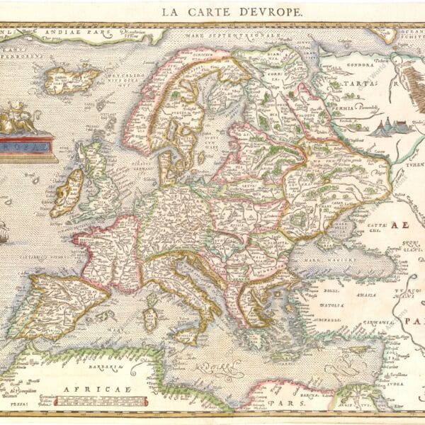
Map of Europe from 1644 (circa) This classic map of Europe is presented in the carte-de-figures style with vignettes on three sides. The upper frieze has nine bird’s-eye views of Amsterdam, Prague, Constantinople, Venice, Rome, Paris, London, Toledo and Lisbon. The side borders contain the costumes of the noblemen and […]
Historical Maps of Brazil and the World
The history of Brazil can be told through maps that represent its territorial transformations over the centuries.
Since the beginning of the 16th century, various cartographies have depicted indigenous scenes, fauna, vegetation, and names attributed to the territory — such as Terra de Santa Cruz, Terra Incógnita, Terra dos Papagaios, and Brasil.
- Early 16th century: maps such as those by Giovanni Ruysch (c. 1507) and Waldseemüller’s chart (1507) were among the first to represent the Americas and name it ‘America.’
- 1500 — reports: the Letter/report by Pero Vaz de Caminha is a document of discovery (not a map) and, together with descriptors such as André Thevet, provides ethnographic observations and observations on bartering between Europeans and indigenous peoples.
- First detailed coastlines: maps such as Cantino’s (1502) show the Brazilian coast with greater precision and helped to establish initial place names.
- 16th century — European cartographers: authors such as Gastaldi, Ortelius and Mercator produced maps that recorded territorial disputes and various names; Mercator (1569) introduced the projection that influenced global navigation (not specific to Brazil).
- Foreign presence and barter: representations documenting the French (e.g., Antarctic France), English, and Dutch presence on the Brazilian coast, as well as commercial contact with indigenous peoples, begin to appear.
- Iberian Union (1580–1640): the Philippine administration (Philippine Crown) encouraged the updating of Luso-Brazilian cartography; maps by Portuguese authors, such as João Teixeira Albernaz I, record fortresses, settlements and captaincies.
- 17th century — Portuguese manuscript cartography: noteworthy are the maps by Albernaz II (c. 1666), which detail the coast, São Paulo and the Jesuit missions in the south.
- Dutch cartography (1624–1654): Dutch cartographic production on Pernambuco/Olinda and Recife is significant; some maps from the period (associated with the Maurits period) document occupations and fortifications — check specific titles/attributions according to the source.
- 18th century — French cartography: Guillaume de L’Isle and Jean Baptiste Bourguignon d’Anville produced maps correcting positions and longitudes previously calculated by the Portuguese; De L’Isle’s work influenced negotiations such as the Treaty of Madrid (1750), which generated extensive cartography of the borders.
- 19th century: provincial, hydrological, and border cartographic production grows. Among minor and handwritten works are regional guides and atlases — for example, references to an atlas/manuscript entitled Guia dos Caminhantes (1817) should be verified in primary sources before definitive citation.
- Late 19th century / early 20th century: systematic surveys and military and civil mapping increased territorial accuracy. The publication entitled Carta geographica do Brasil (Engineering Club, 1922) consolidates part of this work — it is recommended to indicate the author/edition when citing.
Significant Historical Maps of Brazil
- Map by Juan de la Cosa — c. 1500: carta-mundi showing the coastline of the Americas, including northeastern Brazil.
- Letter/account by Pero Vaz de Caminha — 1500: account of the arrival and discovery of Brazil (not a map).
- Cantino Map — 1502: first European map to show the Brazilian coast in detail.
- Map by Lopo Homem — c. 1519: Portuguese cartographic map from the early 16th century (associated with Portuguese Atlantic production; avoid direct attribution to the ‘Miller Atlas’ without reference).
- Mercator Map — 1569: introduced the Mercator projection; influential in global cartography (not specific to Brazil).
- Map by João Teixeira Albernaz I — 1640: representations of the captaincies and the Atlantic coast.
- Map by Guillaume Delisle — 1703: detailed map of Brazilian territory widely used in Europe.
- Maps of the Treaty of Madrid — 1750: maps used in the redefinition of Portuguese-Spanish borders.
- Map of the Empire of Brazil — c. 1822: initial representations of the territory after independence.
- Cruls Mission — 1892–1894: survey that informed the choice of the future capital (Brasília).
Historical maps are essential tools for understanding the territorial, political, and economic evolution of Brazil, from colonisation to the consolidation of the Republic.
Map of the Azores from 1584
Map of the Azores from 1584 Map of the Azores based on the cartography of Luis Teixeira. The islands are shown in good detail and the map is richly embellished with three large ornate cartouches, a title banner, sailing ships and a sea monster. “Acores Insulae”, Ortelius, Abraham. Publication: Theatrum […]
Map of Madeira and the Canary Islands from 1692
Map of Madeira and the Canary Islands from 1692 (circa) Map details the Canary Island group on the left side of the map. The map is filled with rhumblines, fleur-de-lis and many notations and includes a portion of the African coastline. With two large inset charts filling the right half […]
Map of West Africa and the Cape Verde Islands from 1699
Map of West Africa and the Cape Verde Islands from 1699 Map of the important Cape Verde Islands and the opposite African coast from Cap Blanc to Sierra Leone. There is a lot of detail along the African coastline, with numerous cities, capes, rivers, and more identified. A fancy decorative […]
Map of the Cape Verde Islands, 1697
Map of the Cape Verde Islands, 1697 A large copper engraved sea chart of the Cape Verde Islands. A beautiful decorative title cartouche with a sea shell surrounds the title that rests above a scene of Poseidon, mermaids and horses. The chart is further adorned with two sailing ships and […]
Mapping: an Overview
Mapping: A Comprehensive Overview of the History, Science, Techniques and Modern Applications of Cartography The purpose of a map is to express graphically the relations of points and features on the earth’s surface to each other. These are determined by distance and direction. In early times ‘distance’ might be expressed […]
National Surveys and Modern Atlases: Key Developments
National Surveys and Modern Atlases: Evolution, Methods, and Global Practices in Cartography Cartograthy since the early decades of the nineteenth century is characterized by the execution of regular topographical surveys as national undertakings. Most has been accomplished in Europe, in some countries of Asia (e.g. India, Japan, the Dutch East […]
Eighteenth-Century British Advances in Cartography and Surveying
The British Contribution to Cartography in the Eighteenth Century: Instruments, Surveys and Global Mapping Introduction and scope A detailed study of the British contribution to cartography before the eighteenth century lies outside the scope of this outline. Accounts of the achievements of men such as George Lily, Christopher Saxton, Norden, […]
Reformation of Cartography in France – A Historical Overview
In the seventeenth century, the desire to test new hypotheses of the physical universe stimulated attempts to determine accurately the dimensions and figure of the earth, and these then became possible through the invention of more precise instruments to make the necessary observations. These included the telescope, the pendulum clock, […]
Topographical Surveying in the 15th–16th Centuries
As we have seen, new maps of various European countries began to appear in editions of Ptolemy before the end of the fifteenth century. These are in general based on outlines from the marine charts, with contemporary names in place of Ptolemy’s, and some additional features. The latter were probably […]
Cartography of the Great Discoveries: Navigation and Mapping
Charting the Age of Discovery: The Cartography of Early Global Exploration The second great contribution to the revival of cartography was made by the leaders of overseas expansion: the seamen of many nations — Italian, Portuguese, Spanish, French, Dutch and English — who, in little more than a century, opened […]
The revival of Ptolemy’s Geography in the 15th century
The Revival of Ptolemy’s Geography: From Ancient Texts to Renaissance Printed Maps In discussing the latest forms of the medieval mappa mundi, we have had occasion to refer to the spreading knowledge of the maps accompanying the Geography of Claudius Ptolemaeus (or Claudius Ptolemy) in the fifteenth century, and possibly […]
Fifteenth‑Century World Maps: Fra Mauro and Martin Behaim
CONTEMPORARY with the later Catalan maps are several mainly of Italian origin which also preserve some medieval features, but show very markedly the influence of Ptolemy’s ‘Geography’, manuscripts of which were circulating in western Europe at least as early as the opening decades of the fifteenth century. Andreas Walsperger (1448) […]
The Catalan Atlas: Redrawing the Medieval World and Asia
Catalan World Maps: Transforming Medieval Cartography and the Representation of Asia Introduction Another notable stage was reached in the fourteenth century, when European cartographers made the first attempt since classical times to include the continent of Asia within their world picture on the basis of contemporary knowledge. The results of […]
Cartography: From Antiquity to Medieval Maps Explained
From Ancient Surveys to Medieval Mappa Mundi: The Evolution of Cartography Introduction It is often noted that contemporary primitive peoples, ranging from the Inuit of the Canadian Arctic to the Bedouin tribesmen of the Arabian Desert, possess an innate ability to produce rough yet precise sketches on animal hide or […]
Medieval Maritime Cartography Advancements Explained
Medieval Maritime Cartography: The Rise and Development of Portolan Charts Introduction Towards the end of the thirteenth century a new type of chart appeared in Western Europe that marked a major advance in medieval cartography. These charts broke with earlier practice by relying on direct observation aided by the new […]
The evolution of European cartography in the 16th and 17th centuries
The evolution of European cartography (16th-17th centuries): Mercator, Ortelius and the Dutch centres Index Introduction The first atlases and supplements Gerhard Mercator: background and early work The problem of navigation and loxodromes Mercator’s map of Europe (1554) Methods and limitations of ancient cartography The reception of Mercator and other maps […]
1671 Map of Mexico and Central America – Historical Map
1671 Map of Mexico and Central America “Yucatan Conventus Iuridici Hispaniae Novae Pars Occidentalis, et Guatimala Conventus Iuridicus”, Montanus/Ogilby Montanus’ work was perhaps the largest illustrated book on the New World produced in the 17th century. It contains over one hundred beautifully engraved plates, views and maps of North and […]
Map of Africa from 1570
Historical Map of Africa from 1570 Ortelius’ Cornerstone Map of Africa “Africae Tabula Nova”, Ortelius, Abraham Period: 1570 Publication: Theatrum Orbis Terrarum This striking map is one of the cornerstone maps of Africa and remained the standard map of Africa well into the seventeenth century. It was designed by Ortelius […]
Map of Brazil 1730 – Historical Map
Map of Brazil 1730 – Historical Map “Nova et Accurata Brasiliae Totius Tabula, Auctore Ioanne Blaeu I.F.”, Blaeu/Schenk This rare map is Johannes Blaeu’s third map of Brazil. The map includes the hereditary captaincies along the coast and is a significant improvement on Blaeu’s previous maps of Brazil. The beautiful […]
1620 Map of Portugal and Spain – Historical Map
Map of Portugal and Spain, 1620 “Hispaniae Nova Describtio, de integro Multis Inlocis, Secundum Hydrographicas, Desc. Emendata”, Hondius, Jodocus Excellent map of Spain and Portugal, including Majorca and Minorca. Exquisitely engraved by Petrus Kaerius, with elaborate cartouches, sailing ships, sea monsters and compass roses. The sea is engraved in a […]
Map of South America 1601 – Historical Map
Map of South America 1601 – Descripcion de las Indias “Descripcion de las Indias de Mediodia”, Herrera y Tordesillas, Antonio de Antonio de Herrera y Tordesillas was the official historian of Spain and the Indies. He compiled a history of the Spanish conquests and early explorations of the Americas, which […]
1584 World Map – Historical Map
1584 World Map – Theatrum Orbis Terrarum Ortelius’ famous world map – first plate in full contemporary colour “Typus Orbis Terrarum”, Ortelius, Abraham This is the first (of three) world maps included in Ortelius’ famous atlas. It is a simplified reduction of Mercator’s influential map of 1569, presented in an […]
Map of Africa 1593 – Historical Map
Map of Africa 1593 – Speculum Orbis Terrae “Africae Vera Forma, et Situs”, Jode, Cornelis de This extremely rare map is an interesting combination of cartographic sources. Cornelis prepared this map for the second edition of the Speculum after his father’s death in 1591. It replaced the African map of the […]
1575 Map of Europe – Historical Map
Map of Europe from 1575 – Cosmographie Universelle de Tout le Monde Scarce woodcut version of Ortelius’ map of Europe – “Europae”, Belleforest, Francois This rare map is a woodcut version of Ortelius’ map of Europe. The map extends to Iceland and part of Greenland, with a small part of […]
1671 Map of Jamaica
Map of Jamaica of 1671 – Atlas Maritimus “Novissima et Accuratissima Insulae Jamaicae Descriptio”, Seller, John This is the first edition of a very rare English map showing the island divided into districts. In 1670, Sir Thomas Modyford commissioned a survey of the island, which was completed by John Man, […]
1638 Map of the Gulf of Mexico and the Caribbean – Historical Map
Map of the Gulf of Mexico and the Caribbean from 1638 – Theatre du Monde ou Nouvel Atlas… “Insulae Americanae in Oceano Septentrionali, cum Terris Adiacentibus”, Blaeu, Willem This beautiful map of the West Indies reflects the first hand knowledge of Hessel Gerritsz during his voyage to South America and […]
Map of Panama 1699 – Historical Map
Map of Panama from 1699 “A Draft of the Golden & Adjacent Islands, with Part of ye Isthmus of Darien… [on sheet with] A New Map of ye Isthmus of Darien in America, the Bay of Panama, the Gulfs of Vallona or St. Michael…”, Hacke, William (Capt.) Two maps on […]
Map of Brazil from 1606 – Historical Map
Map of Brazil from 1606 – Delle Navigationi et Viaggi Raccolta… “Brazil”, Ramusio, Giovanni Battista This fascinating pictorial map is one of the first regional maps of Brazil. Illustrated with north to the right, the map is full of vignettes depicting native life rather than concentrating on geographical information. Indians […]
Map of the Gulf of Mexico and the Caribbean, 1681
Map of the Gulf of Mexico and the Caribbean, 1681 “Pascaerte van Westindien Begrypende in zich de Vaste Kusten en Eylanden, Alles op syn Waere Lengte en Breete op Wassende Graden Gelegt’, Keulen, Johannes van Van Keulen’s elegantly engraved map of the Gulf of Mexico and the Caribbean was based […]
Map of the Gulf of Mexico, the Caribbean and the Southern United States, 1682
Map of the Gulf of Mexico, the Caribbean and the southern United States, 1682 – Atlas Minor “Insulae Americanae in Oceano Septentrionali ac Regiones Adiacentes, a C. de May Usque ad Lineam Aequinoctialem”, Visscher, Nicolas This beautiful map shows the West Indies, covering the region from the Chesapeake to the […]
Map of South America and the Caribbean 1596 – Historical Map
Map of South America and the Caribbean from 1596 – Itinerario… “Delineatio Omnium Orarum Totius Australis Partis Americae, Dictae Peruvianae, a R. de la Plata, Brasiliam, Pariam, & Castellam Auream…”, Linschoten/Langren This is one of the most impressive and decorative maps of South America and an important early record of […]
Map of the Gulf of Mexico and the Caribbean, 1675
Map of the Gulf of Mexico and the Caribbean, 1675 “Indiarum Occidentalium Tractus Littorales cum Insulis Caribicis / Pascaert van Westindien ende Caribise Eylanden”, Wit, Frederick de This is a scarce first edition of one of the most beautifully engraved maps of the West Indies. It extends to show the […]
1666 Map of the Gulf of Mexico and the Caribbean – Historical Map
Map of the Gulf of Mexico and the Caribbean from 1666 – De Zee-Atlas, ofte Water-Weereld Scarce sea chart with an interesting depiction of the coastline of the USA, “Pascaerte van Westindien de Vaste Kusten en de Eylanden”, Goos, Pieter Goos’s scarce map of the Gulf of Mexico and the […]
Map of the Gulf of Mexico and the Caribbean from 1650-80
Map of the Gulf of Mexico and the Caribbean from 1650-80 – Atlas Minor sive Geographia “Insulae Americanae in Oceano Septentrionali ac Regiones Adiacentes, a C. de May Usque ad Lineam Aequinoctialem”, Visscher, Nicolas This handsome map focuses on the West Indies and covers the region from the Chesapeake through the […]
Southeastern Colonial Map of the United States, Bahamas and Greater Antilles, 1706
Colonial Map of the Southeastern United States, Bahamas and Greater Antilles, 1706 “De Vaste Kust van Chicora Tussen Florida en Virginie, door Lucas Vasquez d’Ayllon en Andere, van Hispaniola Besterend”, Aa, Pieter van der Scarce map of an unusually shaped Florida, with the Carolinas to the north as far as […]
Map of the Gulf of Mexico and the Caribbean, 1594
Map of the Gulf of Mexico and the Caribbean, 1594 – Grands Voyages, Part IV De Bry’s Superb Map of the Southeastern United States, the Caribbean & Northern South America “Occidentalis Americae Partis, vel, Earum Regionum quas Christophorus Columbus Primu Detexit Tabula Chorographicae Multorum Auctorum Scriptis…”, Bry, Theodore de. This […]
Map of Southern South America, 1656 – Historical Map
Map of southern South America from 1656 – Cartes Generales de Toutes les Parties du Monde… “Le Paraguayr, le Chili. La Terre, et les Isles Magellanicques. Various relations”, Sanson/Mariette Excellent map of the southern part of the continent by the influential French cartographer. Particular attention is paid to the river […]
Painting of the Three Kings Fort in Natal from 1647
Painting of the Fort of the Three Kings in Natal from 1647 – Brazil – Rerum per Octennium in Brasilia “Fluvius Grandis”, Barlaeus, Caspar This finely drawn view shows Fort Ceulen (also known as Fort of the Three Wise Men) on the Potengi River in the present-day Natal region. In […]
1607 Map of the Western Hemisphere – Historical Map
Map of the Western Hemisphere of 1607 – America Mercator’s foundation map of America “America sive India Nova, ad Magnae Gerardi Mercatoris aui Universalis Imitationem in Compendium Redacta”, Mercator, Michael This is one of the most famous maps of the Americas and an important base map for a collection of […]
1579 Map of the Western Hemisphere – America – Historical Map
1579 Map of the Western Hemisphere – America – Theatrum Orbis Terrarum Ortelius’ Influential Map of the New World – Second Plate in Contemporary Colour “Americae sive Novi Orbis, Nova Descriptio”, Ortelius, Abraham This is one of the most famous maps of America, which had an enormous influence on the […]
Map of Mexico and Central America, 1671 – Historical Map
Map of Mexico and Central America, 1671 “Yucatan Conventus Iuridici Hispaniae Novae Pars Occidentalis, et Guatimala Conventus Iuridicus”, Montanus/Ogilby Montanus’ work was perhaps the greatest illustrated book on the New World produced in the seventeenth century. It contained over one hundred beautifully engraved plates, views and maps of North and […]
Map of Southern South America, 1668 – Historical Map
Map of southern South America of 1668 – Cartes Generales de Toutes les Parties du Monde… “La Terre et les Isles Magellaniques Tirees des Relations les Plus Recentes”, Sanson/Mariette An unusual map of Patagonia, southern Chile and Tierra del Fuego. Buenos Aires and the mouth of the River Plate are […]
Map of Rio de Janeiro, 1794 – Historical Map
Map of Rio de Janeiro, 1794 “Plan of the Bay and Harbour of Rio-janeiro on the Coast of Brazil”, Laurie & Whittle This rare plan of Rio de Janeiro is based on the work of D’Apres de Mannevillette, with improvements by Sampson Hall, first mate of the Royal Bishop, and […]
Map of Brazil 1698 – Historical Map
Map of Brazil from 1698 – Istoria delle Guerre del Regno del Brasile “Itamaraca, Brazil”, Horatius, Andreas Antonius This magnificent map of the Brazilian province of Itamaraca, including part of Paraíba, was one of the 23 maps in this rare account of the Dutch-Portuguese colonial war. Written by João José […]
Map of Rio de Janeiro from 1682 – Historical Map
Map of Rio de Janeiro 1682 “Pas-kaart, Van de Zee-Kusten van, Brazilia, Tusschen, C.S. Thome en I.S. Catharina…”, Keulen, Johannes van Rare sea chart of the Brazilian coast from the island of Santa Catarina to Cape S. Thomé. Thomé, together with an inset of the Rio Ianeiro (Rio de Janeiro […]
Map of Rio de Janeiro of 1810 – Historical Map
Map of Rio de Janeiro of 1810 “Esquisse de la Ville et du Port de Rio De Janeiro”, Tardieu, Pierre Francois This rare aerial view of Rio de Janeiro shows forts, batteries and landing places for ships. Soundings, anchorages, sandbanks and navigational hazards are shown. A note in the lower […]
Map of Rio de Janeiro of 1764 – Historical Map
Map of Rio de Janeiro of 1764 “Plan de la Baye de Rio-janeiro”, Bellin, Jacques Nicolas This beautiful map shows the Guanabara Bay with an aerial view of Rio de Janeiro. The decorative title cartouche contains a lettered legend identifying 12 locations in the bay, including 6 forts. Guanabara Bay […]
Map of Rio de Janeiro, 1750 – Historical Map
Map of Rio de Janeiro of 1750 “Plan de la Baye et de la Ville de Rio Janeiro…” This beautiful panoramic plan of Rio de Janeiro and Guanabara Bay was created to illustrate the French siege of 1711. A large compass rose points north to right. Numbered and lettered legends […]
Map of Rio de Janeiro, 1840 – Historical Map
Map of Rio de Janeiro from 1840 – Abrege de Geographie… “Rio de Janeiro”, Renouard, Jules This sheet shows a detailed grid plan of Rio de Janeiro. The topography of the surrounding area is well represented. Drawn by A.H. Dufour, engraved by Desbuissons and lettered by Benard. Map of Rio […]
Map of Rio de Janeiro, 1775 – Historical Map
Map of Rio de Janeiro from 1775 – Le Neptune Oriental “Plan de la Baye et du Port de Rio-janeiro…”, Apres de Mannevillette, Jean B. N. D. This important old harbour chart shows Rio de Janeiro in block plan form. All the islands and coastal features are shown, with many […]
Map of the Western Hemisphere from 1700 – Historical Map
Map of the Western Hemisphere, 1700 This sumptuous map of the Americas features a dramatically decorative title cartouche depicting an Amazon queen surrounded by riches, a sugar cane field and exotic animals. Inserted in the cartouche is a small map of the coast of New Zealand. The cartography of North […]
1719 Map of the Western Hemisphere – Historical Map
Map of the Western Hemisphere, 1719 This spectacular wall map is richly engraved in the tradition of Dutch cartography. Although the main focus of the map is the Americas, it also covers the entire Pacific, including the East Indies and Japan, and the entire Atlantic, including much of Western Europe […]
1730 Map of the Western Hemisphere – Historical Map
Map of the Western Hemisphere, 1730 This attractive map is a revision of old Homann’s 1710 map of America. After his death in 1724, his son (Johann Christoph Homann) re-engraved the plate to correct the west coast of North America, which here extends far to the west and north, with […]
1740 Map of the Western Hemisphere – Historical Map
Map of the Western Hemisphere, 1740 This impressive map of the Americas shows a prominent island of California, based on the second Sanson model, with two jagged bays on its north coast. Just above the island is the Strait of Fretum Anian and the coastline of Terra Esonis incognito, obscured […]
1638 Map of South America – Historical Map
Map of South America from 1638 This is an important decorative map of the continent and an essential piece for any South American collection. The coastlines are well detailed, but the interior is full of misinformation. Several rivers (including the Amazon and the Paraguay) flow into the Lago de los […]
1694 Map of South America – Historical Map
Map of South America from 1694 This beautiful map of the continent is decorated with elaborate title and mileage cartouches, which balance the lower part of the map with images of Native Americans, flora and fauna. One cartouche contains the title of the map, while the other shows eight different […]
1730 Map of Northern South America – Historical Map
Map of Northern South America from 1730 This beautiful and important map of the northern part of South America is full of information and annotations speculating on the indigenous tribes and the tributaries of the Amazon. The captains are shown along the coast of Brazil. An annotation in Guyana records […]
Map of Olinda in Pernambuco from 1640 – Historical Map
Map of Olinda in Pernambuco from 1640 This map shows two views of the Portuguese sugar colonies in Brazil during the Dutch invasion in 1630. The top view shows the Dutch fleet attacking the port and fort. Below is a plan of the town of Olinda and its surroundings, with […]
Maritime chart of the east coast of Brazil Ilha Grande and Sapetiba Bay 1884
Marine Map of the East Coast of Brazil Ilha Grande and Sapetiba Bay 1884 Beautiful large scale chart of the region west of Rio de Janeiro. Complete with soundings, anchorages and navigational hazards. In the background is a view of Ilha Grande and the East Passage. The chart was first […]
1823 Map of Brazil – Historical Map
Map of Brazil from 1823 A detailed map of Brazil showing cities, regions, mountains and the extensive river system. Lucas’ General Atlas is considered one of the finest general atlases produced in the USA at the time, due to its high quality paper, excellent engraving and attractive colouring. It was […]
1832 Map of Brazil – Historical Map
Map of Brazil from 1832 Cities, rivers, natives and more. English, Dutch and French Guiana appear to the north of Brazil. Parts of Colombia, Bolivia and Argentina are shown in less detail, and Paraguay and Uruguay are shown as part of Brazil.
Historical maps showing the territorial development of Brazil
The Territorial Formation of Brazil: From Continental Archipelago to National Unity Historical maps and the formation of Brazil Historical Maps show the development and territorial expansion of Brazil and the Western Hemisphere from Discovery to Independence. Learn about the historical facts that led to Brazil’s emergence from a continental archipelago. […]
Engraving of Fort Nassau in Pernambuco, 1671
Engraving of Fort Nassau in Pernambuco, 1671 Montanus’ work was perhaps the largest illustrated book on the New World produced in the 17th century. It contained more than one hundred beautifully engraved plates, views and maps of North and South America. The plates vividly depicted forts, festivals, occupations, Dutch fleets, […]
Map of South America and Brazil 1624 – Historical Map
Map of South America and Brazil, 1624 This engraving is part of a remarkable series of publications illustrating voyages of discovery and exploration in different parts of the world. The project was begun by Theodore de Bry of Frankfurt in 1590 and was to continue for another 54 years. Together […]
Map of the Captaincy of Pernambuco and Ceará from 1680
Map of the Captaincies of Pernambuco and Ceará from 1680 This rare map of the captaincies of Ceará and Pernambuco stretches from the Formosa River to the Estremo River, with the São Francisco River at its centre. Much of the information is derived from maps drawn for the Dutch West […]
Engraving of Vila de Olinda in 1671 – Historical Engraving
Engraving of Olinda, 1671 These splendid views illustrate the Dutch attack on the Portuguese town of Olinda in 1630. For most of the 17th century, Portugal and the Netherlands had a trade agreement whereby the Portuguese colonies in the New World produced sugar and the Dutch distributed it throughout Europe […]
Map of Recife of 1764 – Historical Map
Map of Recife – Brazil – circa 1764 – Publication: Le Petit Atlas Maritime… Volume 2 No. 50 “Plan de Fernambouc a la Coste de Bresil”, Bellin, Jacques Nicolas This fine chart shows the area around Recife (Pernambuco) extending northwards to Olinda. Depth soundings, anchorages and rocks are shown, together […]
1679 Map of Recife – Historical Map
Map of Recife from 1679 A rare aerial map of the city of Recife and its surroundings, showing the Dutch fortifications. Although originally founded by the Portuguese, the Dutch decided to invade several cities in Pernambuco because of the local sugar cane industry. From 1630 to 1654, the Dutch controlled […]
Engraving of the town of Olinda in 1633 – Historical Engraving
Engraving of the town of Olinda, 1633 This is a rare and fascinating aerial view of Olinda and the coast of Pernambuco, based on the work of Hessel Gerritsz, who is credited in the title. It illustrates the attack and capture of the Portuguese settlement of Olinda by a Dutch […]
Map of the Bay of All Saints and Pernambuco, 1700
Map of Baia de Todos os Santos and Pernambuco from 1700 This beautiful decorative map of Brazil is oriented with north to the right. Two insets show Dutch interests in the area (Baia de Todos os Santos and Pernambuco). The interior is largely devoid of geographical information, instead depicting scenes […]
1587 Map of the Western Hemisphere – Historical Map
Map of the Western Hemisphere, 1587 This is one of the most famous maps of the Americas, and one that had an enormous influence on the future cartography of the New World. It was engraved by Frans Hogenberg and is based largely on Gerard Mercator’s large multi-sheet world map of […]
1628 Map of the Western Hemisphere – Historical Map
Map of the Western Hemisphere, 1628 Jodocus Hondius’ map of the Americas is one of the most elaborate examples of fine Dutch cartography. The decorations, including sea monsters, native birds, native canoes and sailing ships, were taken from De Bry’s Grand Voyages. Particularly noteworthy is the scene of the natives […]
1643 Map of the Western Hemisphere – Historical Map
Map of the Western Hemisphere 1643 This impressive carte-a-figure map is an excellent example of the fine art of decorative cartography and a 17th century European view of the New World. The coastal contours generally follow Ortelius and Wytfliet, with the nomenclature of various explorers and settlers. The side panels, […]
1677 Map of the Western Hemisphere – Historical Map
Map of the Western Hemisphere, 1677 Visscher’s map greatly influenced the cartography of the Americas, both geographically and artistically. One of the most striking geographical details copied by other cartographers is the large open lake in the Great Lakes region. In fact, Visscher copied this from Blaeu’s wall map mundi […]
1727 Map of the Western Hemisphere – Historical Map
Map of the Western Hemisphere, 1727 This beautiful map of the Americas is an interesting version of the map series inspired by Nicolas Visscher in 1658. This map was first published by Justus Danckerts around 1696, but the plate was sold by the family to Reiner and Josua Ottens after […]
1628 Map of the Western Hemisphere – Historical Map
Map of the Western Hemisphere, 1628 Jodocus Hondius’ map of the Americas is one of the most elaborate examples of fine Dutch cartography. The decorations, including sea monsters, native birds, native canoes and sailing ships, were taken from De Bry’s Grand Voyages. Particularly noteworthy is the scene of the natives […]
1713 Map of the Western Hemisphere – Historical Map
1713 Map of the Western Hemisphere A highly decorative and detailed map of the Americas, with the island of California prominently featured in the second Sanson model, with a heavily indented northern coast. The British colonies are limited to the east coast by Les Cinq Nationals Iroquoises, while the French […]
1609 Map of the Western Hemisphere – Historical Map
Map of the Western Hemisphere, 1609 Jodocus Hondius’ map of the Americas is one of the most elaborate examples of fine Dutch cartography. The decorations, including sea monsters, native birds, native canoes and sailing ships, were taken from De Bry’s Grand Voyages. Particularly noteworthy is the scene of the natives […]
1714 Map of the Western Hemisphere – Historical Map
Map of the Western Hemisphere, 1714 Van der Aa’s unusual map of America was first published in 1714 and contains interesting geographical myths. In North America, California is shown as an island at the beginning of the Sanson shape, with an almost flat top starting at C. Mendocina. New Albion […]
1550 Map of the Western Hemisphere – Historical Map
Map of the Western Hemisphere, 1550 Sebastian Munster (1489 – 1552) was one of the three most famous cartographers of the 16th century, along with Mercator and Ortelius. Munster’s Geographia and Cosmographia Universalis were two of the most widely read and influential books of the time. His editions of Ptolemy’s […]
1660 Map of the Western Hemisphere – Historical Map
1660 Map of the Western Hemisphere An unusual and splendid figurative map of the Americas. The map combines many different sources, including Luke Foxe’s model of the island of California. The only hint of the Great Lakes is a small L. Content at the end of the St Lawrence River. […]
1587 Map of the Western Hemisphere – Historical Map
Map of the Western Hemisphere, 1587 This is one of the most famous maps of the Americas, and one that had an enormous influence on the future cartography of the New World. It was engraved by Frans Hogenberg and is largely based on Gerard Mercator’s large multi-sheet world map of […]
1631 Map of the Western Hemisphere – Historical Map
Map of the Western Hemisphere, 1631 This is the unusual and larger version of Merian’s map of the Americas. Merian’s bold engraving style copies the cartography of Jodocus Hondius’ 1631 map. North America is depicted with a prominent Virginia and an odd New England coastline. The west coast above California […]
1744 Map of the Western Hemisphere – Historical Map
Map of the Western Hemisphere, 1744 This attractive map is a revision of old Homann’s 1710 map of America. After his death in 1724, his son (Johann Christoph Homann) re-engraved the plate to correct the west coast of North America, which here extends far to the west and north, with […]
1719 Map of the Western Hemisphere – Historical Map
Map of the Western Hemisphere, 1719 This spectacular wall map is richly engraved in the tradition of Dutch cartography. Although the main focus of the map is the Americas, it also covers the entire Pacific, including the East Indies and Japan, and the entire Atlantic, including much of Western Europe […]
1730 Map of the Western Hemisphere – Historical Map
Map of the Western Hemisphere, 1730 This attractive map is a revision of old Homann’s 1710 map of America. After his death in 1724, his son (Johann Christoph Homann) re-engraved the plate to correct the west coast of North America, which here extends far to the west and north, with […]
1697 Map of the Western Hemisphere – Historical Map
1697 Map of the Western Hemisphere This sumptuous map of the Americas features a dramatically decorative title cartouche depicting an Amazon queen surrounded by riches, a sugar cane field and exotic animals. Inserted in the cartouche is a small map of the coast of New Zealand. The cartography of North […]
1579 Map of the Western Hemisphere – Historical Map
Map of the Western Hemisphere 1579 This is one of the most famous maps of the Americas, and one that had an enormous influence on future cartography of the New World. The map is largely based on Gerard Mercator’s large multi-sheet world map of 1569. The most recognisable features of […]
Map of Brazil 1747 – Historical Map of Brazil
Map of Brazil from 1747 Copper engraved map with good detail along the coast with dozens of place names. The map covers the region between northern Paraguay and north to the mouth of the Amazon. A large inset of the island of Santa Catarina fills the empty ocean. In a […]
1592 Map of the Western Hemisphere – Historical Map
Map of the Western Hemisphere, 1592 This engraving is part of a remarkable series of publications illustrating voyages of discovery and exploration in different parts of the world. The project was begun by Theodore de Bry of Frankfurt in 1590 and was to continue for another 54 years. Together they […]
1623 Map of the Western Hemisphere – Historical Map
Map of the Western Hemisphere, 1659 This is a very rare derivative of the important Hondius map of 1618. The engraver is unknown, although it is closely copied from Picart’s version of 1644, which in turn was derived from Jansson’s map of 1623. North America retains the peninsula of California, […]
1581 Map of the Western Hemisphere – Historical Map
Map of the Western Hemisphere of 1581 This is one of the most famous maps of the Americas, and one that had an enormous influence on future cartography of the New World. The map is largely based on Gerard Mercator’s large multi-sheet world map of 1569. The most recognisable features […]
1659 Map of the Western Hemisphere – Historical Map
Map of the Western Hemisphere, 1659 This is a very rare derivative of the important Hondius map of 1618. The engraver is unknown, although it is a close copy of Picart’s version of 1644, which in turn was derived from Jansson’s map of 1623. North America retains the peninsula of […]
Map of the Brazilian Coast from 1678 – Historical Map of Brazil
Map of the Coast of Brazil from 1678 This splendid map of Brazil is mainly a nautical chart with details limited to the coastline. Oriented with north to the left by two fine points of the compass, it covers the Brazilian coast from the mouth of the Amazon to the […]
Map of eastern Brazil 1664 – Historical Map of Brazil
Map of Eastern Brazil 1664 This beautiful map of the Brazilian coast is richly decorated with a scene of natives with a watchtower and a huge fleet of ships. With north to the right, the map covers the coastal region from São Francisco to Recife. It was based on real […]
Map of South America from 1750 – Historical Maps of Brazil
Map of South America from 1750 Beautifully engraved Italian edition of Delisle’s map of South America, extending from Nicaragua to Tierra del Fuego. The place names of South America are mainly concentrated on the coasts and along the Amazon and Paraná rivers. There are also two mythical lakes: Lake Cassipa […]
Map of Brazil 1698 – Historical Maps of Brazil
Map of Brazil from 1698 This magnificent map of Brazil, including parts of neighbouring countries, was one of 23 maps in this rare account of the Portuguese-Dutch colonial war. Written by João José de Santa Teresa, known to bibliophiles as Saint Teresa, it is considered one of the most sumptuous […]
Map of Brazil from 1750 – Historical Map of Brazil
Map of Brazil from 1750 This is a beautiful Italian map of Brazil based on Delisle’s cartography. There is very good detail along the coast and a good amount of information about the interior with numerous annotations and locations of indigenous tribes. The map is decorated with a large pictorial […]
1639 Map of Paraíba – Historical Map of Brazil
Map of Paraíba from 1639 A splendid map of the Paraíba region and the defensive forts at the mouth of the Paraíba River. The map illustrates the Dutch invasion of Portuguese territory, showing the Dutch fleet filling the river and the defending armies marching along the roads. A large and […]
Map of Brazil divided into fourteen hereditary captainships from 1657 onwards
Map of Brazil divided into fourteen hereditary captaincies from 1657 onwards “Le Bresil, dont la Coste est Possedee par les Portugais, et Divisee en Quatorze Capitaineries…”, Sanson, Nicolas Map of Brazil divided into fourteen hereditary captaincies, 1657 – This is a reduced version of Sanson’s important map showing the Portuguese […]
Map of the Captaincy of Paraíba and Rio Grande, 1720
Map of the Captaincy of Paraíba and Rio Grande from 1720 Excellent map of the Brazilian coast, including the captaincies of Paraíba and Rio Grande. The map was drawn after real research by Georg Markgraf, Elias Herckmanns and others and was one of the first maps of Brazil based on […]
Map of All Saints Bay 1769 – Historical Maps
Map of the Bay of All Saints, 1769 This map is a boldly engraved graphic of the Bay of Salvador (Bahia) with an inset plan of the fortified city of Salvador. Navigational soundings and shoals are shown in the bay. Numerous plantations and sugar mills are marked with symbols along […]
All Saints Bay Map of 1644 – Historical Map
Map of the Bay of All Saints, 1644 This rare map of Salvador and the Bay of All Saints shows the Dutch attack and capture of the city of Salvador in May 1624. Salvador, then the capital of Brazil, was a strategic port under Portuguese control. The Dutch, determined to […]
Engraving of Cabo Santo Agostinho from 1645 – Historical Engravings
Engraving of Cape St. Augustin from 1645 This beautiful panoramic view shows the Dutch fleet and the fortifications of Cape St. Augustin. Published by Gregorio Letie, this scene was copied from an earlier publication dating from around 1640. It’s interesting to note that the image was inverted during the engraving […]
Engraving of Sirinhaém from 1671
Engraving of Sirinhaém, 1671 Montanus’ work was perhaps the largest illustrated book on the New World produced in the 17th century. It contained more than one hundred beautifully engraved plates, views and maps of North and South America. The plates vividly depicted forts, festivals, occupations, Dutch fleets, battles, religious rites […]
Engraving of Salvador de Bahia from 1770 – Historical Maps
Copper engraving of Salvador de Bahia, 1770 Salvador, the former capital of Brazil, was a strategic port under Portuguese control. This beautiful engraving shows the walled city of Salvador with ships and boats filling the harbour in the foreground. A key of letters at the bottom identifies various locations. This […]
Map of the Brazilian coast from the Paraíba River to Cabo de Santo Agostinho
Map of the Brazilian coast from Rio Paraíba to Cabo de Santo Agostinho, 1683 “Pas-Kaart, van de Zee-Kusten, van, Brazilia, Tusschen, Punto de Lucena en Cabo S. Augustino”, Keulen, Johannes van This rare and classic sea chart covers the Brazilian coast from the river Paraíba to Cape St. Augustino. Augustino. […]
1757 Map of the Western Hemisphere
1757 Map of the Western Hemisphere This beautiful map of the Americas includes the Solomon Islands. In North America, the Pacific Northwest is left open, completely blank and marked Undiscovered Parts. The coastline ends near Alaska with the note The Alleged Strait of Annian. The British colonies are shown east […]
Map of Brazil from 1850 – Historical Map of Brazil
Map of Brazil from 1850 The maps in The Illustrated Atlas were first published in serial form for an audience isolated by the cost and difficulty of travel. All this changed as the 19th century brought rapid and dramatic changes in public awareness of distant places. Tallis’s maps undoubtedly played […]
Map of the East Coast of Brazil, 1647 – Historical Maps
Map of the East Coast of Brazil from 1647 This beautiful map of the Brazilian coast is decorated at the top with a huge garland of native fruits and a jaguar, tapir and capybara. With north to the right, the map covers the coastal region from São Francisco south to […]
Map of Brazil 1554 – Historical Maps of Brazil
Map of Brazil from 1554 This fascinating pictorial map is one of the first regional maps of Brazil available. Illustrated with north to the right, the map is filled with vignettes depicting native life rather than focusing on geographical information. Indians are shown with bows and arrows, axes, llamas and […]
Map of Brazil 1747 – Historical Maps of Brazil
Map of Brazil from 1747 Copper engraved map with good detail along the coast with dozens of place names. The map covers the region between northern Paraguay and north to the mouth of the Amazon. A large inset of St Catherine’s Island fills the empty ocean. In a long note […]
Map of Cabo Santo Agostinho from 1645 – Historical Map of Brazil
Map of Cape St. Augustin from 1645 This beautiful copper engraved map shows the harbour and fortifications of Cabo Santo Agostinho. Fort Nazaré is shown on a hill to the right. Decorated with a compass pointing north at the top right of the map and a title cartouche in stripes. […]
1671 engraving of Fort Orange on the island of Itamaraca
Orange fort on the island of Itamaraca, 1671 “I. Tamaraca”, Montanus, Arnoldus Montanus’ work was perhaps the largest illustrated book on the New World produced in the 17th century. It contained more than one hundred beautifully engraved plates, views and maps of North and South America. The plates vividly depicted […]
Engraving of the Fort of the Three Kings in Natal, 1671
Engraving of the Fort of the Three Kings in Natal, 1671 Montanus’s work was perhaps the largest illustrated book on the New World produced in the 17th century. It contained more than one hundred beautifully engraved plates, views and maps of North and South America. The plates vividly depicted forts, […]
Reis Magos Fort Engraving from 1690 – Engravings Stories
Engraving of the Fort Reis Magos from 1690 – Natal An aerial view of the fort (now Natal) at the mouth of the River Potengi, showing the Dutch invasion and capture of the Portuguese fort in 1633. The harbour is full of ships and armies are shown rushing to defend […]
Gravura da Baia de Todos os Santos de 1690
Gravura da Baia de Todos os Santos de 1690 Bela gravura em cobre ilustrando a frota holandesa capturando o forte na entrada da Baía de Todos os Santos, no nordeste do Brasil. A cena é muito ativa com canhões ondulantes e pequenas figuras correndo para a ação. Grande plano de […]
Map of Cabo de Santo Agostinho from 1690
Map of Cape St. Augustin from 1690 This beautiful panoramic view shows the Dutch fleet and the fortifications of Cape St Augustine. The strapwork title cartouche contains a numbered key identifying four locations. – “Afbeeldinge vande Cabo St. Augustin met Haer Forten”, Leti, Gregorio Map of Cabo de Santo Agostinho […]
Map of Paraíba of 1690 – Historical Maps of Brazil
Map of Paraíba from 1690 This panoramic map shows the region of Paraíba and the Portuguese fortifications at the mouth of the Paraíba River. The scene of the Dutch attack on the region is illustrated with the Dutch fleet and the defence of the Portuguese armies. “Afbeeldinghe van Pariba ende […]
Map of Brazil from 1630: Cartography’s Legacy
Map of Brazil from 1630 This beautiful map was a collaboration between Hessel Gerritsz, official cartographer of the Dutch East India Company, and Johannes de Laet, director of the newly formed Dutch West India Company. His maps of South America laid the foundations for many other cartographers. The detail is […]
Map of Brazil from 1652: A Historical Perspective
Map of Brazil from 1652 Beautiful depiction of Brazil with north oriented to the right by a beautiful compass rose. The map shows two regions of Dutch interest in the area, Baía de Todos os Santos and Pernambuco. The interior is devoid of geographical information, except for largely imaginary rivers […]
Engraving of Salvador from 1671: A Historical Insight
Engraving of Salvador from 1671 Montanus’s work was perhaps the greatest illustrated book on the New World produced in the 17th century. It contained over a hundred beautifully engraved plates, views and maps of North and South America. The plates vividly depicted forts, festivals, occupations, Dutch fleets, battles, religious rites […]
Engraving of Todos os Santos Bay from 1671 Explained
Engraving of Todos os Santos Bay from 1671, Brazil Montanus’s work was perhaps the greatest illustrated book on the New World produced in the 17th century. It contained over a hundred beautifully engraved plates, views and maps of North and South America. The plates vividly depicted forts, festivals, occupations, Dutch […]
Map of Brasil from 1757: Historic Coastal Views
Map of Brazil from 1757 – L’Histoire Generale des Voyages… “[Lot of 2] Suite du Bresil Depuis la Baye de Tous les Saints Jusqu’a St. Paul [and] Suite du Bresil pour Servir a l’Histoire Generale des Voyages”, Bellin, Jacques Nicolas This pair of copper engraved maps covers the coastline of Brazil […]
Map of Brazil from 1850: A Historical Overview
Map of Brazil from 1850 The maps in The Illustrated Atlas were first published as a series for an audience that was isolated by the cost and difficulty of travel. All this changed as the nineteenth century brought rapid and dramatic changes in public awareness of distant places. Undoubtedly, Tallis’s […]
Map of South America from 1740: Historical Insights
Map of South America from 1740 Beautifully engraved Italian edition of Delisle’s map of South America, extending from Nicaragua to Tierra del Fuego. Place names in South America are mainly concentrated along the coasts and along the Amazon and Paraná rivers. Two mythical lakes also appear: Lake Cassipa Dorada (a […]
Map of South America from 1619: A Historical Insight
Map of South America published in 1619 Excellent folio map of the continent, added by Jodocus Hondius for publication in his continuation of the Mercator Atlas. The interior shows the great mythical Parime Lacus straddling the equator and an equally interesting river system. The huge Rio de la Plata flows […]
Map of South America from 1615: Explore the Details
Map of South America published in 1615 Excellent folio map of the continent, added by Jodocus Hondius for publication in his continuation of the Mercator Atlas. The interior shows the great mythical Parime Lacus straddling the equator and an equally interesting river system. The huge Rio de la Plata flows […]
Map of Recife in Pernambuco from 1679: Historical Insights
Map of Recife in Pernambuco from 1679 – Brazil A rare aerial view of the city of Recife and its surroundings, particularly notable for its Dutch fortifications. Although originally founded by the Portuguese, the Dutch decided to invade several cities in Pernambuco due to the local sugar cane industry. From […]
Copper Engraving of Salvador from 1748: History Explored
Copper engraving of Salvador, Bahia, 1748 This sheet shows two views of São Salvador, the capital of colonial Brazil. At the top is a panoramic view of the city’s fortifications, and at the bottom is a perspective view of Fort St Bartholomew and its protective harbour. Below is a key […]
Map of Brazil from 1798: Explore Historical Details
Map of Brazil from 1798 This is an unusual Italian map of Brazil, Paraguay and Uruguay. It covers the area around Buenos Aires. It provides a good level of detail, including extensive river systems. The large landscape-style title page shows Indians tending a fire. “Brazil and the Land of the […]
Map of the Province of Paraíba from 1698 Overview
Map of the Province of Paraíba from 1698 This impressive map covers the province of Paraíba, showing its major rivers and flourishing sugar cane plantations. It was one of 23 maps in this rare account of the Dutch-Portuguese colonial war. Written by João José de Santa Teresa, known to bibliophiles […]
Map of Brazil from 1695: A Historical Overview
Map of Brazil from 1695 This rare and beautiful map is Johannes Blaeu’s third map of Brazil. Designed by Joannes de Broen and engraved by Abraham Wolfgang, it was completed shortly before the great fire that destroyed the printing works and was therefore never included in Blaeu’s atlases. In 1694 […]
Map of South America, 1840
Map of South America, 1840 This impressive large map is taken from Louis Stanislas D’Arcy Delarochette’s monumental eight-sheet map of South America, which was used to settle countless boundary disputes across the continent. It contains the most up-to-date geographical information and numerous interesting annotations. Three insets at the bottom of […]
Map of Paraíba from 1662: An Engraved Masterpiece
Map of Paraíba from 1662 Excellent map of the Brazilian coast, including the captaincies of Paraíba and Rio Grande. The map was drawn after actual surveys by Georg Markgraf, Elias Herckmanns and others, and was one of the first maps of Brazil based on non-Portuguese data. The map is richly […]
View of Rio de Janeiro in 1840: Beauty Captured
View of Rio de Janeiro in 1840 This is a fine view of Rio de Janeiro and its harbour, drawn by E. Duncan and engraved by R.A. Prior. “Rio de Janeiro”, Blackie, W.G. & Son
Map of the Captaincy of Espírito Santo and Porto Seguro from 1698
Map of the Captaincy of Espírito Santo and Porto Seguro from 1698 This impressive map covers the coast from Rio de Janeiro to about Ilhéus. It was one of 23 maps in this rare account of the Dutch-Portuguese colonial war. Written by João José de Santa Teresa, known to bibliophiles […]
Map of South America from 1650: A Historical Overview
Map of South America from 1650 This attractive map shows the continent with Sanson’s characteristic attention to detail. The relatively unknown Amazon region is the subject of little speculation. The mythical Lac de Parime still appears, with the legendary Manoa del Dora (City of Gold) on its western shore, although […]
Map of the Captaincy of Pernambuco from 1698 Overview
Map of the Captaincy of Pernambuco from 1698 This magnificent map of the Brazilian province of Pernambuco was one of 23 maps in this rare account of the Portuguese-Dutch colonial war. Written by João José de Santa Teresa, known to bibliophiles as Santa Teresa, it is considered one of the […]
Map of Santa Catarina Island 1777: A Historical Treasure
Map of Santa Catarina Island 1777 This is a rare Spanish map of the island of Santa Catalina, now the city of Florianópolis and a major tourist destination. It shows the unspoilt island with a few small villages and several sheltered anchorages. A view of the approach to the coast […]


