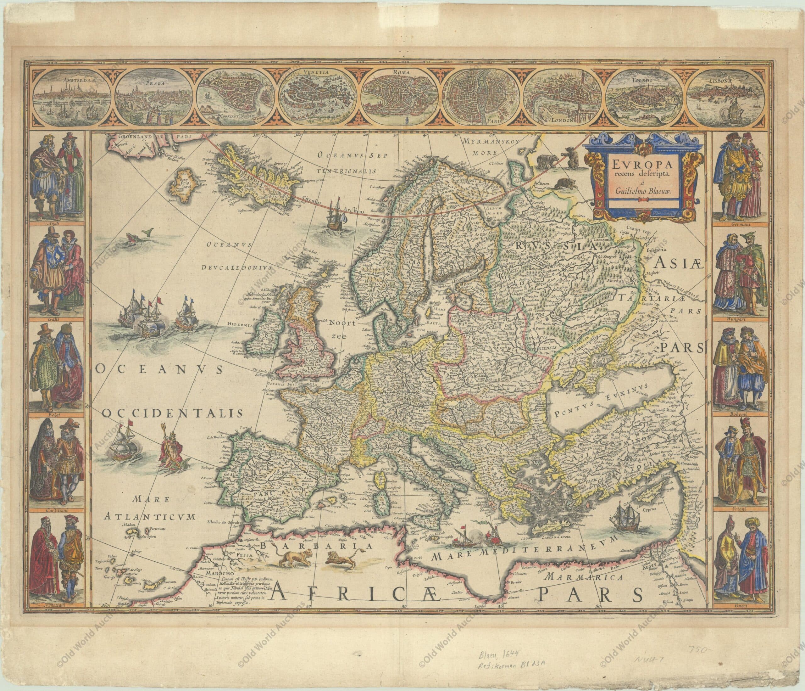
Publication: Theatrum Orbis Terrarum – Blaeu’s Carte-a-Figures Map of Europe – “Europa Recens Descripta”, Blaeu, Willem
Map of Europe from 1644 (circa)
This classic map of Europe is presented in the carte-de-figures style with vignettes on three sides. The upper frieze has nine bird’s-eye views of Amsterdam, Prague, Constantinople, Venice, Rome, Paris, London, Toledo and Lisbon.
The side borders contain the costumes of the noblemen and women of ten European nations. The map is embellished with sailing ships, sea monsters, bears and Neptune riding a dolphin and holding his trident.
A beautiful map produced at the height of the Golden Age of Dutch mapmaking; it was included in the first volume of Blaeu’s magnificent atlas. Latin text on verso, published between 1644-55.
Publication: Theatrum Orbis Terrarum – Blaeu’s Carte-a-Figures Map of Europe – “Europa Recens Descripta”, Blaeu, Willem
Publicações Relacionadas
Painting of the Three Kings Fort in Natal from 1647
1628 Historical Map of the Western Hemisphere
Map of South America from 1740: Historical Insights
1628 Map of the Western Hemisphere - Historical Map
Map of the Brazilian coast from the Paraíba River to Cabo de Santo Agostinho
1575 Map of Europe - Historical Map
Map of Recife in Pernambuco from 1679: Historical Insights
Map of Rio de Janeiro of 1764 - Historical Map
1643 Map of the Western Hemisphere - Historical Map
All Saints Bay Map of 1644 - Historical Map
Map of the Captaincy of Pernambuco from 1698 Overview
Reis Magos Fort Engraving from 1690 - Engravings Stories
Engraving of the Fort of the Three Kings in Natal, 1671
1659 Map of the Western Hemisphere - Historical Map
Map of Brazil from 1606 - Historical Map
Map of Brazil from 1630: Cartography's Legacy
Map of Brazil from 1750 - Historical Map of Brazil
Engraving of the town of Olinda in 1633 - Historical Engraving
Map of Brazil 1554 - Historical Maps of Brazil
The Catalan Atlas: Redrawing the Medieval World and Asia
1757 Map of the Western Hemisphere
Map of the Captaincy of Paraíba and Rio Grande, 1720
1587 Historical Map of the Western Hemisphere
Map of Cabo de Santo Agostinho from 1690
Map of Southern South America, 1668 - Historical Map
Engraving of Salvador de Bahia from 1770 - Historical Maps
Map of Africa 1593 - Historical Map
Map of Rio de Janeiro, 1750 - Historical Map
Map of Brazil from 1652: A Historical Perspective
Historical maps showing the territorial development of Brazil
Map of South America from 1619: A Historical Insight
Southeastern Colonial Map of the United States, Bahamas and Greater Antilles, 1706
Map of the Brazilian Coast from 1678 - Historical Map of Brazil
Map of Rio de Janeiro, 1840 - Historical Map
1587 Map of the Western Hemisphere - Historical Map
Map of the East Coast of Brazil, 1647 - Historical Maps
This post is also on:
![]() Português
Português ![]() English
English ![]() Deutsch
Deutsch ![]() Español
Español ![]() Français
Français


