Map details the Canary Island group on the left side of the map. The map is filled with rhumblines, fleur-de-lis and many notations and includes a portion of the African coastline. With two large inset charts filling the right half resting on a tasseled drapery background. The upper inset is a detailed chart of the island of Madeira, a volcanic archipelago in the North Atlantic north of the Canary Islands. The town of Madera (Fanchal) is shown below in a birds eye view that includes several ships in the harbor with the fortified town at the shore. The map is very decorative and beautifully engraved in Coronelli’s characteristic style. Dedicated to Alvise da Mosto, “Procr di S. M. Sauio Grande.” Blank verso. Vincenzo Coronelli was a Franciscan priest and renowned mathematician and cartographer. He was appointed official Cosmographer to the Venetian Republic in 1685 and founded the world’s earliest geographic society, L’Accademia Cosmografica degli Argonauti. “Isole Canarie Possedutte da S.M. Cattolica…”, Coronelli, Vincenzo Maria. – Publication: Atlante Veneto
Map of Madeira and the Canary Islands from 1692 (circa)
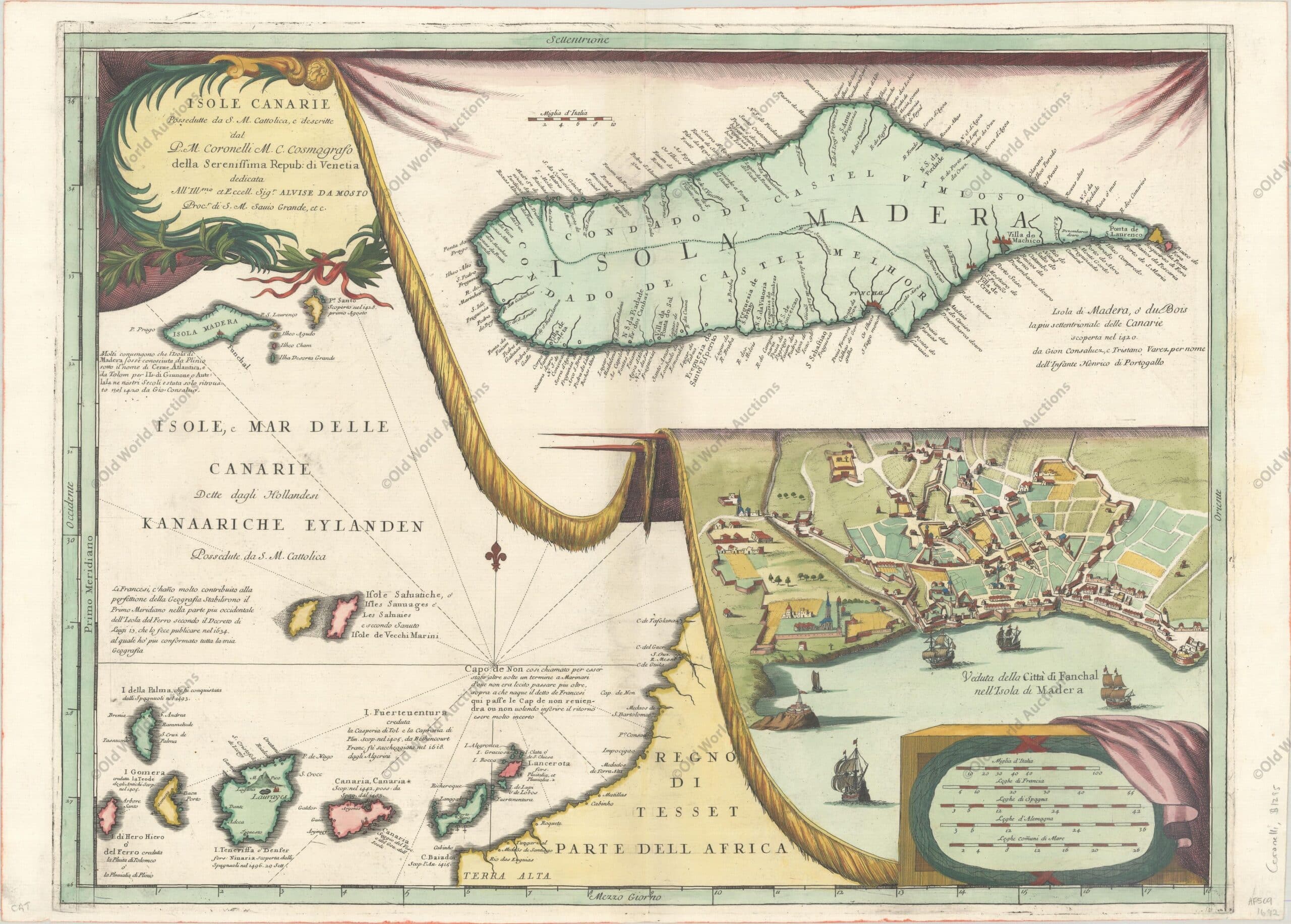
Map details the Canary Island group on the left side of the map.
The map is filled with rhumblines, fleur-de-lis and many notations and includes a portion of the African coastline.
With two large inset charts filling the right half resting on a tasseled drapery background.
The upper inset is a detailed chart of the island of Madeira, a volcanic archipelago in the North Atlantic north of the Canary Islands. The town of Madera (Fanchal) is shown below in a birds eye view that includes several ships in the harbor with the fortified town at the shore.
The map is very decorative and beautifully engraved in Coronelli’s characteristic style.
Dedicated to Alvise da Mosto, “Procr di S. M. Sauio Grande.” Blank verso. Vincenzo Coronelli was a Franciscan priest and renowned mathematician and cartographer.
He was appointed official Cosmographer to the Venetian Republic in 1685 and founded the world’s earliest geographic society, L’Accademia Cosmografica degli Argonauti. “Isole Canarie Possedutte da S.M. Cattolica…”, Coronelli, Vincenzo Maria. – Publication: Atlante Veneto
Publicações Relacionadas
Map of South America from 1650: A Historical Overview
Map of South America from 1750 - Historical Maps of Brazil
1823 Map of Brazil - Historical Map
Engraving of Salvador from 1671: A Historical Insight
Map of South America from 1615: Explore the Details
1671 engraving of Fort Orange on the island of Itamaraca
1592 Map of the Western Hemisphere - Historical Map
Map of Africa 1593 - Historical Map
Map of South America from 1619: A Historical Insight
1744 Map of the Western Hemisphere - Historical Map
1631 Map of the Western Hemisphere - Historical Map
Map of Rio de Janeiro, 1794 - Historical Map
Map of Rio de Janeiro of 1764 - Historical Map
1740 Map of the Western Hemisphere - Historical Map
1719 Historical Map of the Western Hemisphere
Map of South America from 1740: Historical Insights
1587 Historical Map of the Western Hemisphere
Engraving of Cabo Santo Agostinho from 1645 - Historical Engravings
Map of Santa Catarina Island 1777: A Historical Treasure
1620 Map of Portugal and Spain - Historical Map
Map of the Western Hemisphere from 1700 - Historical Map
Map of Brazil from 1630: Cartography's Legacy
Engraving of Vila de Olinda in 1671 - Historical Engraving
1719 Map of the Western Hemisphere - Historical Map
1638 Map of the Gulf of Mexico and the Caribbean - Historical Map
1607 Map of the Western Hemisphere - Historical Map
1694 Map of South America - Historical Map
1584 World Map - Historical Map
Map of Brazil 1698 - Historical Maps of Brazil
1628 Historical Map of the Western Hemisphere
Historical maps showing the territorial development of Brazil
Map of the Gulf of Mexico, the Caribbean and the Southern United States, 1682
Map of the Province of Paraíba from 1698 Overview
1666 Map of the Gulf of Mexico and the Caribbean - Historical Map
Engraving of Todos os Santos Bay from 1671 Explained
1730 Map of the Western Hemisphere - Historical Map
This post is also on:
![]() Português
Português ![]() English
English ![]() Deutsch
Deutsch ![]() Español
Español ![]() Français
Français


