Discover the Chapada Diamantina: a natural and cultural paradise in Bahia
The Chapada Diamantina is one of the most popular destinations for nature lovers. There you and your family will see a place full of caves, caverns, rivers, waterfalls, trails, hills, among others.

Geomorphology and biodiversity
The Chapada Diamantina is made up of imposing canyons, hidden caves, waterfalls and plant species found nowhere else in the world.
The Chapada extends over 24 municipalities in central Bahia and its symbol is the Pai Inácio Hill, at an altitude of 1,120 metres.
Geographically, the heart of Bahia lies in the Chapada Diamantina.
This mountainous region, with its varied topography, is the source of 90% of the state’s rivers, including the three largest – all from Bahia – which form the main watersheds of the state: the Paraguaçu, Jacuípe and Rio de Contas.
Natural beauty and vegetation
There are thousands of kilometres of crystal-clear waters that flow from the peaks, cascade down the mountains and flow across plateaus and plains to form beautiful fountains and natural pools.
The beauty of the water is complemented by the exuberant vegetation, which mixes cacti from the caatinga with rare examples of mountain flora, especially bromeliads, orchids and the evergreen flower.

Heights and Attractions
Chapada Diamantina is home to the three highest peaks in the state: Pico das Almas, at 1,958 metres, Itobira, at 1,970 metres, and Barbados, at 2,080 metres, which is the highest point in the northeast.
This is due to the geography of the region, which is an extension of the Espinhaço orographic system in Minas Gerais, which vertically divides the waters of the coast and the São Francisco River.

The region is also home to the 420-metre-high free-falling Fumaça Waterfall and the fascinating Poço Encantado (Enchanted Well), which thrills so many visitors.
There are so many natural attractions that you can choose between underground routes to the caves and waterfalls, walking along old prospectors’ trails or riding through valleys such as Pati amidst esoteric and alternative communities.
Legends and heritage
From the Capa Bode mountain range in Mucugê, it’s even possible to see alien spaceships in the sky, as many of the town’s inhabitants have done.
The historical heritage of the Chapada Diamantina tells the story of the mining saga in every alley and in the centuries-old mansions of the towns of Lençóis, Rio de Contas, Andaraí, Mucugê and the tiny mountain district of Xique-Xique do Igatu, “the city of stones”.
These towns were born and flourished with the Ore Cycle, from the 17th century onwards, when there was a fever for gold, diamonds and the dream of getting rich quick. The districts and villages that make up the municipalities of the Chapada Diamantina have something of the fantastic that fascinates visitors.
Settlements and fantastic legends
The first settlements in the region, these hamlets, if not completely uninhabited, seem frozen in time and space.
The inhabitants, mostly old people and children, tell stories of evil colonels, hidden treasures, sacrificed slaves who ended up as ghosts, hauntings or something similar. Among the most fantastic is the Legend of Pai Inácio, which has been made into a film script.

Chapada Diamantina National Park
The Chapada Diamantina National Park was created by federal decree in 1985 and covers an area of 152,000 hectares in and around the Sincorá mountain range, between the municipalities of Lençóis, Palmeiras, Andaraí, including the district of Igatu, and Mucugê.


Many ecologists, government technicians and representatives of the Chapada communities suggest a new limitation, as several beautiful areas in need of protection lie outside the park, such as Morro do Pai Inácio, Gruta da Pratinha, Gruta Azul, Poço Encantado and Gruta da Lapa Doce, among others.


Video about the places of interest in Chapada Diamantina

As belezas da Chapada Diamantina - Guia Turístico
Tourist Attractions, Itineraries and Tips for Chapada Diamantina
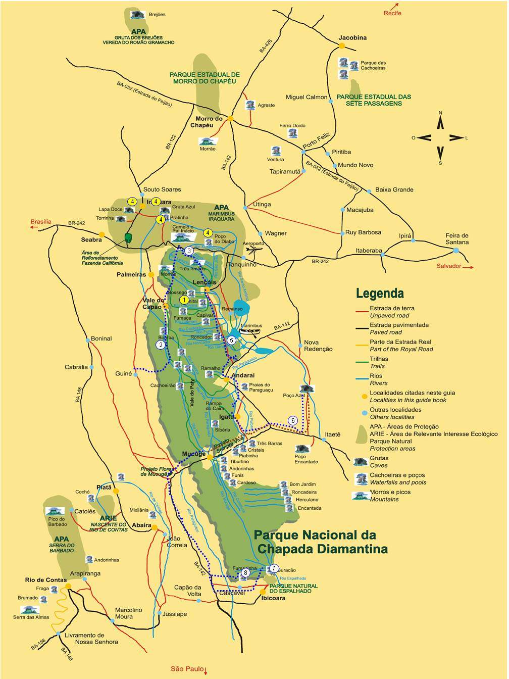
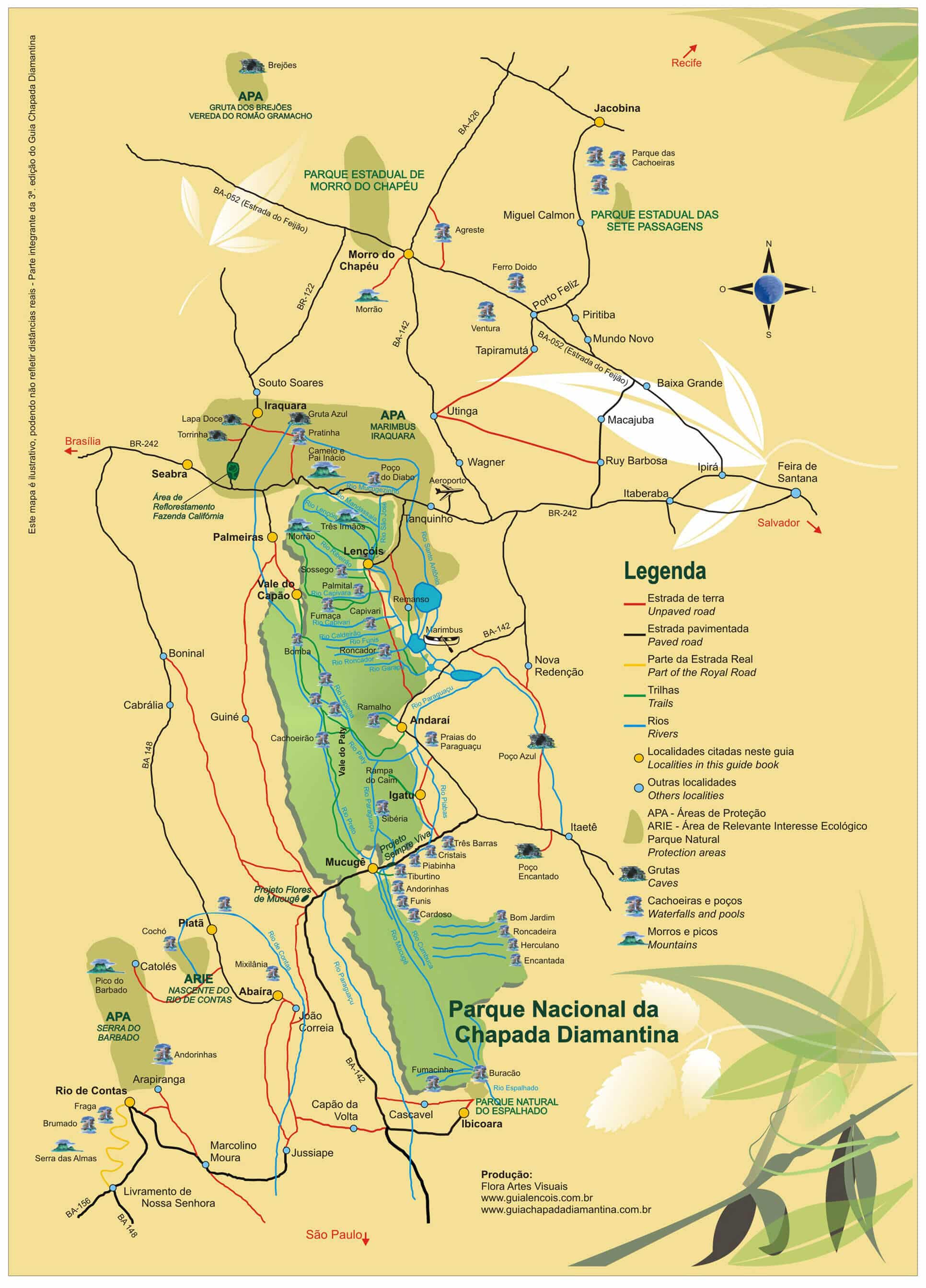
- Map of Chapada Diamantina National Park
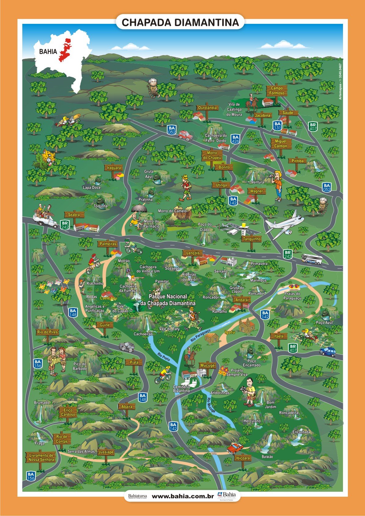
- Map of Chapada Diamantina
- Map of routes and tourist attractions
- The highest and most beautiful waterfalls
- History of Garimpo
- Vila do Ventura and hiking trail in Morro do Chapéu
- Igatu, Poço Azul and Poço Encantado
- Marimbus is the mini Pantanal
- Trekking to Pico das Almas, Pico do Barbado and Pico do Itobira
- The evergreen flower typical of Chapada Diamantina becomes a symbol of conservation
- Emerald hunters
- Discover the dive sites
- Caves in the municipality of Campo Formoso, Bahia
- Rio de Contas is considered the first planned city in Brazil
- Curiosities of Rio de Contas
- Rio de Contas travel guide
- Rio de Contas is one of the oldest cities in the region.
- Piatã is the highest mountain town in the Northeast at 1180 metres above sea level.
- Palmeiras had its glory days with diamond mining.
- Mucugê is situated at an altitude of 900 metres in a privileged landscape.
- Morro do Chapéu is 1012 metres above sea level and enjoys a pleasant climate.
- Lençóis is the gateway
- Ibicoara is also known as the “City of Caves”.
- History and tourist guide of Ibicoara, Bahia
- Andaraí, the second main town
- Chapada Diamantina is world famous
- Pati Valley – Trekking in the heart of Chapada Diamantina
- Trekking – Route through the Chapada Diamantina
- Blue fountain
- Enchanted fountain
- Torrinha Cave in Iraquara
- Lapão Cave
- Lapa Doce Cave and Pratinha Cave
- Trekking in Pati Valley
- Fumaça Waterfall in Vale do Capão
- Trekking – Most popular trails
- Orchids of Chapada Diamantina
- The charm of the Fumaça waterfall
- Buracão Waterfall
- Chapada Diamantina Relief, Fauna and Flora
- Documentaries
- Chapada Diamantina travel guide
- 5 waterfalls you must see in Chapada Diamantina
- The main towns in Chapada Diamantina region
- Birds found in Chapada Diamantina BA.
Bahia.ws is the biggest tourist guide of Chapada Diamantina
Publicações Relacionadas
Orchids of the Chapada Diamantina in Bahia
History of the settlement of Chapada Diamantina
Waterfalls and trails in the Capão Valley: Complete Guide
Enchanted fountain in Chapada Diamantina: How to get there
Curiosities about the Rio de Contas in Chapada Diamantina
Tourist Information about Chapada Diamantina
Trail to Buracão Waterfall in Chapada Diamantina
Lapão Cave: The Ultimate Adventure Experience
Birds Found in Chapada Diamantina: A Guide
Igatu: Explore the 19th-Century Stone Houses
Things to do in Lençóis in the Chapada Diamantina — 15 attractions
Mucugê: Discover the local history and culture
Trekking in the Pati Valley in Chapada Diamantina
Tourist Attractions and Documentaries about Chapada Diamantina
Main Towns and Villages in the Chapada Diamantina Region
Andaraí is the second largest town in the Chapada Diamantina
Tourist Attractions in Rio de Contas You Must Visit
Piatã: The Highest Municipality in Bahia
Campo Formoso: Explore Caves and Emerald Trade
Waterfalls of Chapada Diamantina: A Guide for Adventurers
The History of Lençóis in the Chapada Diamantina — Origins, the Diamond Cycle and Heritage
How to get to Fumaça Waterfall in Chapada Diamantina
Dive Sites of Chapada Diamantina: A Guide
Torrinha Cave: A Speleological Marvel in Brazil
Chapada Diamantina's architectural style and influences
Relief, Fauna and Flora of Chapada Diamantina
Ventura Village: A Rich History of Diamonds
Trekking - Popular trails in Chapada Diamantina
Ecological tourism in Morro do Chapéu
Trekking - Route through the Chapada Diamantina in 7 days
Ibicoara: An Unmissable Tourist Destination
Sempre-Viva: Symbol of Preservation in the Chapada Diamantina
Mining in the Chapada Diamantina History Explained
Picos das Almas, Itobira and Barbado Trekking Guide
Iraquara is also known as the "city of caves"
Main caves in the municipality of Iraquara in Chapada Diamantina
This post is also on:
![]() Português
Português ![]() English
English ![]() Deutsch
Deutsch ![]() Español
Español ![]() Français
Français


