Explore the natural and cultural wealth of Campo Formoso, Bahia: Caves and emeralds
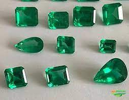
The town of Campo Formoso in Bahia is known for its caves and emerald trade.
Campo Formoso is located in the Chapada Diamantina and has many caves with different types of interior formations.
It also has the largest cave in the southern hemisphere: Toca da Boa Vista, the largest known cave in Brazil and the Southern Hemisphere, with more than 120 km of galleries mapped in 2007, it is one of the most important speleological and palaeontological sites in Brazil.

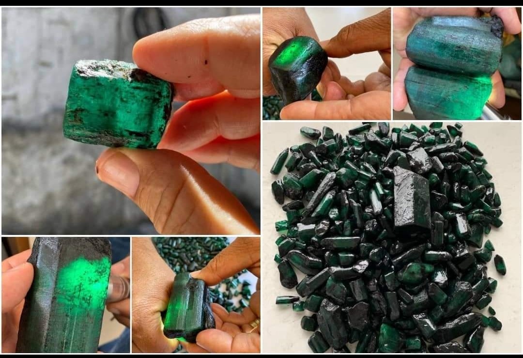
The municipality of Campo Formoso, 414 kilometres from Salvador, is famous for its emerald production and hosts the Jewels, Emeralds and Handicrafts Fairs.
Together with the neighbouring Caves, Toca da Barriguda, Toca do Calor de Cima, Toca do Pitu and Toca do Morrinho, they form a group of geological importance worldwide.
Videos about “Campo Formoso in Bahia

Grutas de Campo Formoso05:08
Campo Formoso e suas grutas06:46
Caçadores de Esmeraldas12:15
História de Campo Formoso06:44
Curiosidades sobre as esmeraldas de Campo Formoso06:45
Caves in the parish of Campo Formoso
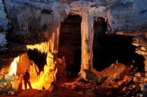
1. Boa Vista Cave
The largest cave in the Southern Hemisphere, with 102.5 km mapped and topographed by the Bambuí Group for speleological research, it ranks 11th among the largest caves in the planet. It has an atypical morphology that is extremely rich from a scientific point of view.

Numerous fossils found there have allowed us to expand our knowledge of the palaeontology of Pleistocene vertebrates. Important studies in the fields of palaeotoclimatology and karst geology will also be carried out.
The cave also contains speleothems of exotic mineralogy and rare morphology. It is a large dry labyrinth, with narrow passages leading to large halls.
The largest of these is the Salão Telécio hall, named in honour of José Telesphoro, the great leader of Campo Formoso and the pioneer who entered and saw the great potential of the Gruta da Boa Vista.
The most beautiful rooms are: the Canal of the Flying Saucers, the Other World, the New World, the Third World and the last section, called the End of the World.
The state of conservation of this cave is very good, as its visitation has so far been limited to speleologists and other scientists with experience of the cave’s ecosystem.

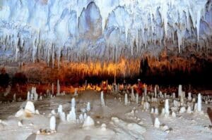
2 Barriguda Cave
Toca da Barriguda is the 2nd largest cave in Brazil. This spectacular cave is in many ways more scenic than Toca da Boa Vista, its larger neighbour.

Its magnificent halls are an enchantment to the eyes of all who enter.
It consists of large halls decorated with stalactites and stalagmites, oozes and the Canal of the Caatinga, which covers 16,400 m² and is undoubtedly the most beautiful hall in the region, both for the “forest” of stalagmites on the floor and the curious ceiling full of cupuias.
Toca da Barriguda is also of great scientific importance, with fossil bones and palaeoenvironmental evidence abundant in this cave, making it an important natural museum.
Its route is 30 kilometres long, mapped and topographed by the Bambuí Speleological Research Group.
3 Sumidouro Bridges in Campo Formoso
The complex consists of three limestone bridges that cross the Pacuí River, traces of a large cave through which the river once flowed underground. The gaps between these bridges are large drops from the ceiling of the ancient cave.

The first bridge, 85 metres long, is characterised by a large volume of collapsed blocks and rare speleothems, with waterfall shapes on the side walls and travertines in the river bed. It is interesting to note that there is a road over this natural bridge.
Bridge II, which is 305 metres long, already has a higher density of speleothems, both on the roof and on the side walls (stalactites, waterfalls, curtains and others). The floor is flat and consists of wet clay deposited during the floods of the Pacuí River.
Walking along the banks of the river for 95 kilometres you reach Bridge III. This is the largest and most beautiful bridge, 310 metres long, with a large number of carbonate deposits, such as numerous travertines, columns, pearls and others.
The floor is similar to that of Bridge II, made of clay from the floodplain of the Pacuí River, which flows between bluish rocks and coarse sands that shine in the clear caatinga sun.
4 Convent Cave
The Gruta do Convento, near the village of Abreus, is very large and stands out both for its underground beauty, framed by skylights, and for its religious value, attracting pilgrims devoted to Our Lady of Aparecida, who has been venerated there for decades.

It has been known since the 8th century, when saltpetre mines were discovered and exploited in the Abreus region. Travelling through the cave is extremely easy due to the horizontal nature of the galleries. Several skylights let in light, enhancing the beauty of the cave and providing easy access to the surface.
The cave is in good condition. This is due to the large size of the galleries and the absence of speleothems in accessible areas.
The cave has intermittent streams: the Queixo D’Anta and the Tanquinho, which rise in the Serra do São Francisco, west of the village of Abreus.
Despite having concentrations of stalactites, stalagmites and curtains on the walls, this cave resembles an immense pressure conduit where the waters of a large tributary of the Pacuí River once circulated, forming an integrated circuit of caves that are easy to visit due to their proximity.
5. Toca da Onça or Tiquara Cave
Toca da Onça or Gruta da Tiquara is located at 10º 24′ 46″ south latitude and 40º 24′ 46″ west longitude, almost on the outskirts of the village of Tiquara. Inside there are some cave paintings.

Among the paintings observed, there is a similarity to the São Francisco/geometric tradition, which is quite common in the state of Minas Gerais. According to Valentim Calderon, the São Francisco tradition is similar to the Symbolist tradition.
The paintings were badly damaged by saltpetre mining in the 1930s and are also heavily graffitied.
The Tiquara Cave is extremely important in characterising the predominant style of rock art in the region, and its traces differ from all the others found in the sites we visited.
Campo Formoso – Geographical Location
The municipality of Campo Formoso is located in the north of Bahia, to the west of the Jacobina Mountain Range. Its history dates back to the beginning of the colonisation of the interior of Colonial Brazil (17th century).
Its territory includes the Salitre Valley, whose river of the same name is a tributary of the right bank of the São Francisco River.
The city is 400 kilometres from Salvador, which can be reached by the BR-324 motorway to Senhor do Bonfim, from where it is 24 kilometres on a paved road that links the two cities. Despite its proximity to the Catinga, the city has a mild climate, with nights cooled by the trade winds that pass through the mountain range that surrounds the region.
Location: Polígono das secas, north of the state of Bahia, Vale do São Francisco region, Senhor do Bonfim micro-region.

Boundaries:
North: Juazeiro and Sobradinho.
South: Antonio Gonçalves, Mirangaba and Umburanas.
East: Senhor do Bonfim and Jaguarari.
West: Sento Sé
History of Campo Formoso
Formerly the Old Parish of Santo Antônio do Sertão da Jacobina, its baroque name recalls the 17th century. It was the first settlement to appear in the north of Bahia. In 1682, Arraial was elevated to the category of a parish by the 1st Archbishop of Bahia, D. Gaspar Barata de Mendonça.
Jacobinas was the name given to the low, thorny vegetation that made up the sertão in Bahia. It was inhabited by the Sapóias, Paiaiás, Tocós and Secaquerinhens Indians, all of whom belonged to the Quiriris group and formed the great Tapuias nation.

The first Portuguese to arrive in Jacobinas were the bandeirantes from Bahia. They included: Belchior Dias Moréia, discoverer of the legendary silver mine, and his son Robério Dias, lord of Casa da Torre; Francisco Dias D’Avilla and his brother Father Antonio Pereira, founder of the Sesmaria, which included the lands of the Freguesia Velha de Santo Antônio da Jacobina; the brothers Manoel and João Calhelha and Lourenço de Matos, discoverers of the Jacobinas, who moved to the settlement of Freguesia Velha “where they lived and died”; Bento Surrel, discoverer of the saltpetre and salt mines in the Salitre River Valley.
The first missionaries arrived in the hinterland of Jacobinas in 1655 and found more than eighty villages of different tribes: the Sapoiás, the Paiaiás, the Eveninhens, etc..
On 22 July 1722, by order of the Viceroy of the State of Brazil, the sertanista Pedro Barbosa Leal founded the village of Santo Antônio de Jacobina in Sítio do Sahay, near the mission of Nossa Senhora das Neves do Sahay.
The choice of this location was motivated by the refusal of the Vicar of the Old Parish of Santo Antônio and the Lord of Casa da Torre, who did not accept the installation of the village in the Arraial of Santo Antônio, the seat of the Old Parish of Santo Antônio.
Two years later, the village was transferred to the mission of Bom Jesus da Glória de Jacobina Nova (now the town of Jacobina).
The main engine of progress in the region of Freguesia Velha de Santo Antônio was the exploitation of saltpeter ore in Pacuí (Nossa da Encarnação workshop) and in the mines of João Martins and João Peixoto.

This ore was transported by donkey to the port of Bahia and then to Portugal. Saltpetre was used to make gunpowder for the war industry.
Then came the period of cattle breeding, with the establishment of farms and corrals run by overseers, cowboys and drovers.
In 1770, the inhabitants of Arraial da Freguesia Velha sent a large petition to King José I, asking that the town be elevated to the category of village. Despite reasonable arguments, no decision was made. And the town of Santo Antônio waited 110 years for the fulfilment of its people’s longing.
It was on July 28th of the glorious year of 1880 that Provincial Law No. 2051, signed by the Governor of the Province of Bahia, D. Antonio de Araújo Bulcão, created the town of Campo Formoso (formerly the old parish of Santo Antônio do Sertão da Jacobina), with all the boundaries of the parish. It was founded three years later, in 1883.
In 1939, its seat was elevated to city status by Decree-Law No. 11.089 of 30 November 1938.
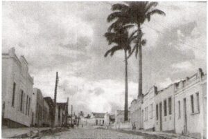
Situated on the slopes of the Serra da Jacobina, Campo Formoso is a city of slopes and hills.
The commercial centre, government offices, hotels, hospital, churches and old residences are located on the Morro dos Alecrins.
With progress, the city grew towards the surrounding hills, forming several districts: Esplanada, São Francisco, Vila Pernambucana, Vila dos Sonhos, Bosque das Mangueiras, Santa Luzia, Colina do Sol, Baixa dos Tapuias, Serra do Cruzeiro, Centro Cultural, Guabiraba and others.
Bahia.ws is the largest travel and tourism guide in Bahia and Salvador.
Tourist guide of Campo Formoso in Bahia
Publicações Relacionadas
Iraquara is also known as the "city of caves"
Waterfalls and trails in the Capão Valley: Complete Guide
Wine Tourism in the São Francisco Valley Guide
Curiosities about the Rio de Contas in Chapada Diamantina
Ecological tourism in Morro do Chapéu
Palmeiras: A Gateway to Chapada Diamantina
How to get to Fumaça Waterfall in Chapada Diamantina
Chapada Diamantina - Tourist Attractions, Itineraries and Tips
Relief, Fauna and Flora of Chapada Diamantina
Rio de Contas: Learn about the history of how the city was founded
History of grape and wine production in the São Francisco Valley
Ventura Village: A Rich History of Diamonds
Birds Found in Chapada Diamantina: A Guide
Santa Rita de Cássia: Attractions and Activities
Chapada Diamantina's architectural style and influences
Bom Jesus da Lapa Sanctuary: Faith, History and Natural Beauty in Bahia
Discover the São Francisco River Valley Region - Tourist Guide
Trekking - Route through the Chapada Diamantina in 7 days
Trekking in the Pati Valley in Chapada Diamantina
Main caves in the municipality of Iraquara in Chapada Diamantina
Tourist Attractions and Documentaries about Chapada Diamantina
History of the settlement of Chapada Diamantina
Juazeiro: Discover the Land of the Carrancas
Correntina: Discovering the Heart of Bahia
Andaraí is the second largest town in the Chapada Diamantina
Marimbus Pantanal: Adventure in Chapada Diamantina
Rio de Contas: An Unmissable Tourist Destination
Main Towns and Villages in the Chapada Diamantina Region
Waterfalls of Chapada Diamantina: A Guide for Adventurers
Barreiras: Where Carnival Meets Adventure Tourism
Enchanted fountain in Chapada Diamantina: How to get there
The History of Lençóis in the Chapada Diamantina — Origins, the Diamond Cycle and Heritage
Sempre-Viva: Symbol of Preservation in the Chapada Diamantina
Mucugê: Discover the local history and culture
Paulo Afonso's Beautiful Waterfalls and Canyons
The highest and most beautiful waterfalls in Chapada Diamantina
This post is also on:
![]() Português
Português ![]() English
English ![]() Deutsch
Deutsch ![]() Español
Español ![]() Français
Français


