Mucugê: Discover the natural and cultural beauty of Chapada Diamantina
Mucugê is located at an altitude of 900 metres, in the middle of a privileged landscape. The town is surrounded by beautiful mountains, rivers, waterfalls and caves.

History and Architecture
As you can see, Mucugê is rich in history, with old colonial houses in Portuguese style. The main backdrop to this history is mining, an activity that still takes place here, although on a much smaller scale.
Events and culture
The city has a full calendar of events that attracts tourists from many regions. It also has museums, a philharmonic orchestra and planned, tree-lined squares.
Urban beauty
The streets of Mucugê are meticulously clean, surrounded by flowerbeds, beds and gardens, and surrounded by mountains. The town has a wide range of tourist facilities to suit all tastes: hotels, hostels, inns and guesthouses.
The bars and restaurants are busy and spill out onto the streets in the evenings, with tables and chairs lining the pavements.

National Heritage
Listed as a national heritage site by the IPHAN (Instituto do Patrimônio Histórico e Artístico Nacional), Mucugê is built on the edge of the Serra do Sincorá. Surrounded by mountains, the average temperature in the city is 19˚C.
Natural highlights
The main highlight is the Mucugê Municipal Park, home to the Sempre-Viva Project, which focuses on environmental, education and conservation, and the Garimpo Living Museum.
The municipality is privileged by its location, as 52% of its territory is part of the Chapada Diamantina National Park.
The first diamond
Mucugê was considered one of the most beautiful towns in the Chapada Diamantina and had a reasonable infrastructure to receive visitors. It was here, 48 kilometres from Andaraí, that the first diamond was found.
The story goes that on June 25th 1844, Cristiano Pereira do Nascimento, godson of Colonel Cazuza do Prado, one of the region’s great ranchers, went to wash his hands in the Cumbuca stream and found a diamond.
The news spread quickly and soon the diamond rush began – everyone wanted to wash their hands in the stream!

The impact of mining
Mining attracted large landowners from other states to Mucugê, bringing their families and slaves with them.
Diamond mining also attracted many Europeans and Arabs, leading to power struggles, fights over land, slaves and the best digging sites.
Changes and new directions
When the mines ran out in 1870, the town turned to other activities, such as farming and agriculture. Mucugê serves as a base for excursions into the surrounding area, with a programme that can include visits to caves and waterfalls, walks or bike rides along the trails and canoeing on the rivers.
Flora conservation
The Sempre Viva Project, based in Mucugê, promotes the study of the local flora and tries to preserve the Sempre Viva flower, which was on the verge of extinction due to predatory exploitation for export in large quantities to Europe, where it was used to decorate hats.
Videos about Mucugê in the Chapada Diamantina

História de Mucugê na Bahia02:53

Mucugê Guia de Turismo02:13

Cemitério Bizantino em Mucugê04:49

Mucugê Documentário12:47

Andaraí e Mucugê09:42
Pontos Turísticos de Mucugê - Reportagem06:57
See also the Chapada Diamantina Tourist Attractions
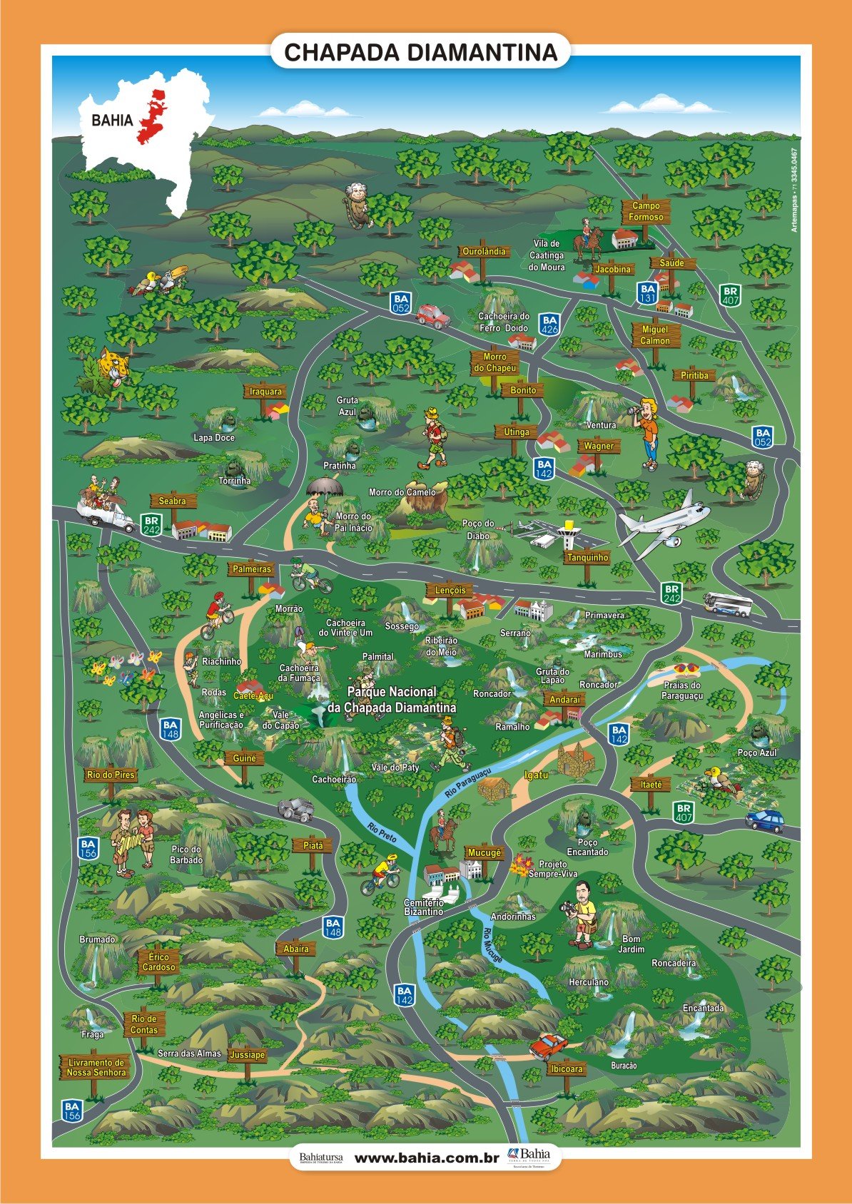
See the Chapada Diamantina map
Mucugê Tourist Attractions
- Byzantine Cemetery (CEMITÉRIO SANTA ISABEL)
- Church of St Elizabeth
- Public Archives
- Mucugê Municipal Park
- Sempre Viva Project
- Garimpo Living Museum
- Siberia Waterfall
- Funis Waterfall
- Cardoso Waterfall
- Andorinhas Waterfall
- Crystal Waterfall
- Serra do Capa Bode
The first diamonds in the Chapada Diamantina were discovered in this beautiful town in 1844.

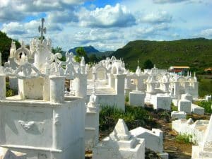
One of its most interesting attractions is the only Byzantine cemetery in Brazil, which catches the eye of anyone arriving in the city. Houses and flower-filled squares adorn the town, which has also been declared a National Heritage Site by the National Historical and Artistic Institute (Iphan), built on the edge of the Serra do Sincorá.
1. Byzantine Cemetery (CEMITÉRIO SANTA ISABEL)
Built between 1854 and 1886, the Santa Isabel Cemetery is located on the rocky slopes of Serra do Sincorá.

The site was chosen because of a cholera epidemic that led the church to ban burials in the church. It has a series of mausoleums that reproduce miniature church facades and whitewashed chapels, earning it the name “Byzantine cemetery”.
Those who died of the disease could not be buried in the church, as was customary, for fear of spreading the epidemic.
To “compensate” their dead for not being buried in the holy ground of a Christian temple, families built beautiful mausoleums in the Byzantine and Gothic styles, imitating church facades.
2. Church of Santa Isabel

This is the town’s main church, built by slaves in the 19th century.
3. Public Archives
This room contains documents, films and photographs relating to the history of the city.
4. Mucugê Municipal Park
Maintained by the City Council with the support of the State and the Catholic University of Salvador, the park houses a centre for the conservation of local flora and fauna.
Within the park are the Plabinha and Tiburtino waterfalls, freely accessible to visitors and excellent for swimming. The Tiburtino waterfall is one of the falls of the Cumbuca stream, where the first diamonds were found.
5. Sempre Viva Project

The Projeto Sempre Viva (Always Alive Project) is a quiet, easy and very enjoyable hike dedicated to the conservation of a small and charming flower, the evergreen, often used in bridal bouquets.
Once threatened with extinction due to over-exploitation, this little plant now has a safe place to show why it’s so sought after – once taken out of the ground it doesn’t change its appearance for up to 60 years!.
The evergreen flower is typical of the Chapada Diamantina and has become a symbol of conservation.
6. Garimpo Living Museum
The Garimpo Living Museum is housed in an old prospector’s cave, which has been restored and adapted to display objects related to the history of the Diamantina Cycle, which began in Mucugê.

Visitors can immerse themselves in the history of diamond mining in Bahia, discovering natural diamonds and carbonates, 19th century English cutting machines, all the tools used by prospectors and much more.
A visit to the Garimpo Museum is a real immersion in the history not only of Mucugê, but also of the Chapada Diamantina.
7. Siberia Waterfall

Those willing to brave the obstacles to reach the foot of this 5m high waterfall hidden in a canyon will be dazzled by the 200m high stone wall.
8. Funis Waterfall

Waterfall with five natural steps, considered the most beautiful in the area.
9. Cardoso Waterfall

Much of the route consists of trails flanked by beautiful rock formations and fields of evergreen trees.
10. Andorinhas Waterfall

Formed by several waterfalls. A little paradise!
11. Crystal Waterfall

This recently discovered waterfall is located at the bottom of a canyon.
The trail leads through fields where you can see many species of bromeliads and orchids.
12. Serra do Capa Bode
Flying saucers are said to have appeared here at an altitude of 1,200 metres. Astronomy courses for groups are held there.
History of Mucugê
The fascinating history of Mucugê
Mucugê has an interesting history, beginning with its foundation in the 18th century, and is considered one of the oldest in the Chapada Diamantina. It was also the place in Bahia where the first valuable diamonds were discovered by a prospector known as Cazuza do Prado in 1844.

The diamond rush
This discovery attracted thousands of people to the region in search of wealth, and a veritable race to find possible diamond deposits around the Mucugê River. By 1848, what was once a small settlement had grown to over 30,000 inhabitants, most of them prospectors and traders. That’s when the town of Mucugê do Paraguaçu was founded.
Development and opulence
During this period, the region developed in a prosperous manner. You can still see the opulent mansions that dominate the town centre, even in the cemetery. This is because in 1855, after an outbreak of cholera ravaged the country, an imperial decree aimed at curbing the high number of deaths forbade the burial of people in churches, a common practice at the time.
The cemetery and local architecture
Having nowhere to bury their dead, the authorities of Mucugê chose an interesting place to build the cemetery: at the foot of a mountain opposite the town. As this was an old mining region, very rich at the time, no resources were spared and in some cases the architects took great care in creating the ornamented tombs, imitating small churches and Catholic temples.
Economic transition
In 1870, however, diamond mining collapsed, forcing the region to find alternative economic activities. Thus, coffee growing and livestock breeding became the main sources of income for São João do Paraguaçu, the name by which the town was known in 1890, when it was elevated to the status of a parish.
Rise and fall
In 1917 the town was officially renamed Mucugê. At the same time, the region experienced a deep economic decline, with a high rate of migration, which continued throughout the first half of the 20th century.
Exploitation of evergreen flowers
Given the scale of the economic crisis they were facing, they began to exploit the fields of evergreen flowers, a plant species with more than 400 varieties in the region. The European continent became the largest exporter of the plant, which was used as a decorative item. Today, some endemic species of the plant are threatened with extinction.
Rebirth through tourism
Finally, tourism has arrived, allowing us to combine the historical, cultural and environmental preservation of the city, while also serving as a source of income for thousands of families living not only in the area, but throughout the surrounding region.
Bahia.ws is the largest tourist guide to Bahia and Salvador.
Mucugê, from historic town to tourist destination in Bahia
Publicações Relacionadas
Palmeiras: A Gateway to Chapada Diamantina
History of the settlement of Chapada Diamantina
The highest and most beautiful waterfalls in Chapada Diamantina
Chapada Diamantina - Tourist Attractions, Itineraries and Tips
Orchids of the Chapada Diamantina in Bahia
How to get to Fumaça Waterfall in Chapada Diamantina
Campo Formoso: Explore Caves and Emerald Trade
Trail to Buracão Waterfall in Chapada Diamantina
Andaraí is the second largest town in the Chapada Diamantina
Tourist Information about Chapada Diamantina
Iraquara is also known as the "city of caves"
Rio de Contas: Learn about the history of how the city was founded
The History of Lençóis in the Chapada Diamantina — Origins, the Diamond Cycle and Heritage
Enchanted fountain in Chapada Diamantina: How to get there
Piatã: The Highest Municipality in Bahia
Trekking - Route through the Chapada Diamantina in 7 days
Mining in the Chapada Diamantina History Explained
Main Towns and Villages in the Chapada Diamantina Region
Torrinha Cave: A Speleological Marvel in Brazil
Ibicoara: An Unmissable Tourist Destination
Picos das Almas, Itobira and Barbado Trekking Guide
Tourist Attractions in Rio de Contas You Must Visit
Relief, Fauna and Flora of Chapada Diamantina
Chapada Diamantina's architectural style and influences
Sempre-Viva: Symbol of Preservation in the Chapada Diamantina
Igatu: Explore the 19th-Century Stone Houses
Trekking in the Pati Valley in Chapada Diamantina
Tourist Attractions and Documentaries about Chapada Diamantina
Birds Found in Chapada Diamantina: A Guide
Things to do in Lençóis in the Chapada Diamantina — 15 attractions
Dive Sites of Chapada Diamantina: A Guide
Waterfalls and trails in the Capão Valley: Complete Guide
Waterfalls of Chapada Diamantina: A Guide for Adventurers
Ecological tourism in Morro do Chapéu
Curiosities about the Rio de Contas in Chapada Diamantina
Ventura Village: A Rich History of Diamonds
This post is also on:
![]() Português
Português ![]() English
English ![]() Deutsch
Deutsch ![]() Español
Español ![]() Français
Français


