Piatã is the highest mountain town in the entire Northeast.
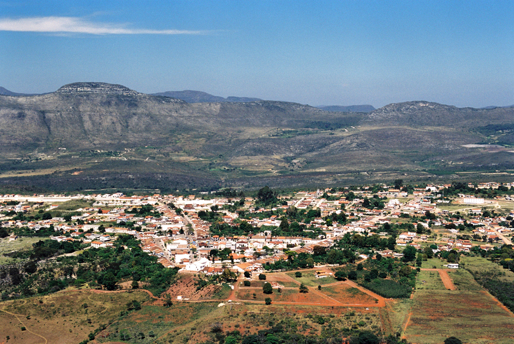
Piatã is a municipality in the state of Bahia in Brazil. It is the highest and coldest municipality in the state, as well as in the entire Northeastern Region of Brazil.
With an altitude of 1,280 metres, it surpasses other highland municipalities in Bahia such as Morro do Chapéu, Rio de Contas and Vitória da Conquista.

Geography and altitude
Piatã still has higher plateau areas on the outskirts of its urban centre, which rise to 1,500 metres. With an altitude of 1,180 metres, it is the highest mountain city in the whole of the Northeast and the oldest settlement in the Chapada Diamantina.
It is located on a plateau between the Serra da Tromba – an extension of the Serra da Mantiqueira, where the sources of the Rio de Contas and Rio Machado are – and the Serra do Santana, with its chapel of Senhor do Bonfim.
History of settlement
Settlement began in the mid-17th century with the discovery of mines in the Tromba and Santana mountains by prospectors, which attracted a large number of adventurers in search of gold and precious stones.
In the municipality of Minas do Rio de Contas (now Rio de Contas), the town of Bom Jesus dos Limões (now Piatã) was founded, which was born on the banks of the Estrada Real (Royal Road), a road opened by the explorer Pedro Barbosa Leal in 1725, connecting Rio de Contas with Jacobina.
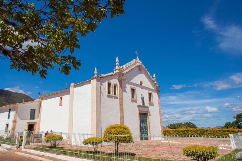
Historical heritage
The Mother Church of Bom Jesus, located in the Vicar Souza Square, and the Chapel of Our Lady of the Rosary date from this period.
Festivities
The June Festivities are the most celebrated, both in urban and rural areas, and are characterised by a bountiful table of typical seasonal products and a “chill” that can reach 3 or 4ºC. The average annual temperature never exceeds 20ºC.
On June evenings, the coldest of the year, there is always a artisanal liqueur, a “quentão” (a typical local drink) or a hot coffee, planted and harvested in the city’s backyards.
Natural attractions
The Waterfalls of Patrício, Cochó, Rio de Contas, Malhada da Areia, Encontro das Águas, Gerais do Rio de Contas, Bica do Machado, Serra do Santana, Serra do Navio, Serra da Tromba and Três Morros are among the main natural attractions of Piatã, located 568 kilometres from Salvador.

Meaning of the name
The name Piatã comes from the Tupi language and means “firm footing” or “the fortress”.
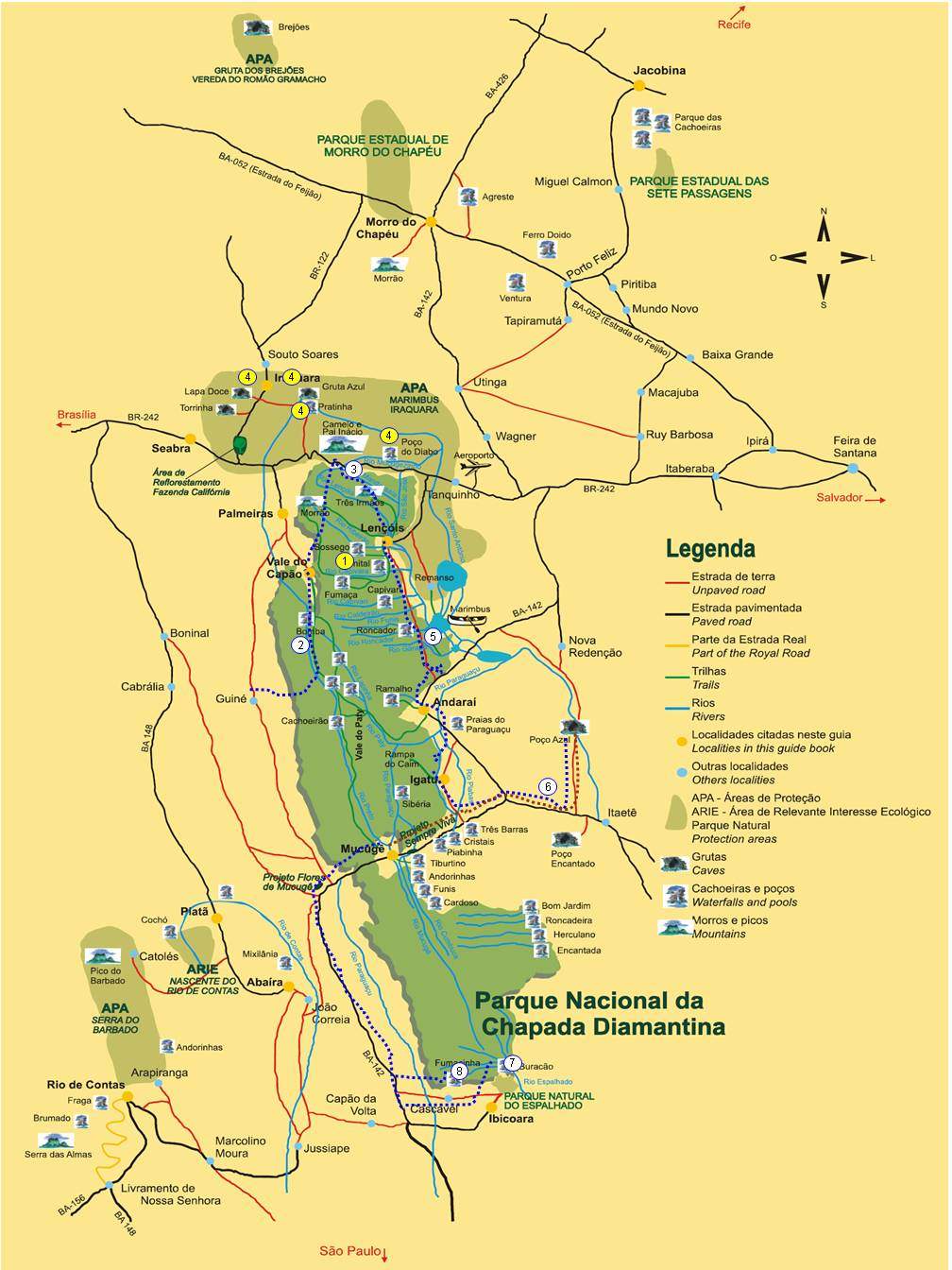
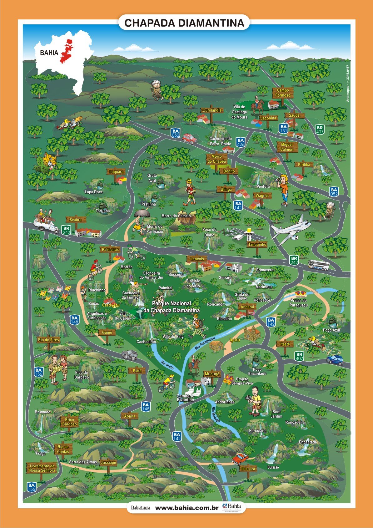
See the map of Chapada Diamantina National Park
Video of Piatã in Chapada Diamantina
Piatã na Chapada Diamantina05:54
História de Piatã na Chapada Diamantina
Piatã - Reportagem41:12

PIATÃ VISTA DO CÉU05:05
History of the city of Piatã
Historians point out that the city of Piatã, the oldest in the Chapada Diamantina, was founded in the context of the expansionist movement of the 17th century.
This process led to bandeirantes penetrating the hinterland of the Rio de Contas in search of precious stones and especially gold.
These expeditions reached the Serra de Santana and Serra da Tromba mountains, where black amocambados had been found since 1680.
At the beginning of the 17th century, with the discovery of large gold deposits in the Serra de Santana, a church with carved stone walls and portals was built.
Later, a small settlement grew up around the church, on a plateau between the valleys of two mountains, Santana and Tromba.

The bandeirantes, such as Pedro Barbosa Leal, commissioned by the viceroy, the Count of Sabugosa, played a crucial role in the exploration of the region. Leal was responsible for opening a road between Rio de Contas and Jacobina.
Another important figure was Captain Major Antônio Veloso da Silva, who, under orders from the Bahian government, fought fierce Indians and runaway blacks in the interior.
In 1732 he was ordered to travel down the Rio de Contas to transport material for the construction of a foundry and to open better roads to the mines.
In 1738, after a violent confrontation with Indians, he founded a cattle ranch in what is now the municipality of Jussiape.
The settlement, originally called Bom Jesus dos Limões, grew with the arrival of men in search of wealth. It became part of the municipality of Minas do Rio de Contas, and in 1842 the district of Bom Jesus dos Limões was created by Provincial Law No. 169.
The area underwent administrative changes over time:
- In 1878, by law 1813, the district was renamed Bom Jesus do Rio de Contas.
- In 1931, by State Decree 7479, the name was changed to Anchieta.
- In 1943, by State Decree no. 141, the seat and the municipality were renamed Piatã.
In 1962, Piatã lost part of its territory with the emancipation of the parishes of Abaíra and Boninal.
Tourist guide to Piatã in Chapada Diamantina
Publicações Relacionadas
Andaraí is the second largest town in the Chapada Diamantina
Torrinha Cave: A Speleological Marvel in Brazil
Tourist Attractions in Rio de Contas You Must Visit
Curiosities about the Rio de Contas in Chapada Diamantina
Relief, Fauna and Flora of Chapada Diamantina
Trekking in the Pati Valley in Chapada Diamantina
Trekking in the Pati Valley in Chapada Diamantina
Trekking - Route through the Chapada Diamantina in 7 days
Tourist Information about Chapada Diamantina
Ibicoara: An Unmissable Tourist Destination
Mucugê: Discover the local history and culture
Igatu: Explore the 19th-Century Stone Houses
Orchids of the Chapada Diamantina in Bahia
How to get to Fumaça Waterfall in Chapada Diamantina
Ventura Village: A Rich History of Diamonds
The History of Lençóis in the Chapada Diamantina — Origins, the Diamond Cycle and Heritage
Enchanted fountain in Chapada Diamantina: How to get there
Dive Sites of Chapada Diamantina: A Guide
Campo Formoso: Explore Caves and Emerald Trade
Waterfalls of Chapada Diamantina: A Guide for Adventurers
Picos das Almas, Itobira and Barbado Trekking Guide
Ecological tourism in Morro do Chapéu
Trekking - Popular trails in Chapada Diamantina
Sempre-Viva: Symbol of Preservation in the Chapada Diamantina
Blue Fountain in Chapada Diamantina: a complete guide
Palmeiras: A Gateway to Chapada Diamantina
Main Towns and Villages in the Chapada Diamantina Region
Waterfalls and trails in the Capão Valley: Complete Guide
Iraquara is also known as the "city of caves"
History of the settlement of Chapada Diamantina
Main caves in the municipality of Iraquara in Chapada Diamantina
Chapada Diamantina - Tourist Attractions, Itineraries and Tips
Tourist Attractions and Documentaries about Chapada Diamantina
Rio de Contas: An Unmissable Tourist Destination
Lapão Cave: The Ultimate Adventure Experience
Rio de Contas: Learn about the history of how the city was founded
This post is also on:
![]() Português
Português ![]() English
English ![]() Deutsch
Deutsch ![]() Español
Español ![]() Français
Français


