Rio de Contas, one of the oldest cities in the Chapada Diamantina region, is notable for its 17th-century Baroque architecture, which has been preserved to the present day.
In 1745, at the height of the gold rush, it was planned as Brazil’s first planned city, reflecting the prosperity of the time.
Rio de Contas is home to communities of Portuguese descendants, who maintain cultural traditions and usually marry only among themselves, living at 1500 metres above sea level.
In another area, at 1050 metres, there are two black communities made up of African descendants.
The Municipal Historical Archive of Rio de Contas holds valuable documents such as Letters of Release, Ecclesiastical Judgments and Slave Certificates, which provide a historical overview of the area.

The region’s rich flora has attracted the attention of researchers. In 1974, more than 100 English and Brazilian scientists carried out an extensive study of the local diversity, identifying more than 1100 species, more than 100 of which were previously unknown.
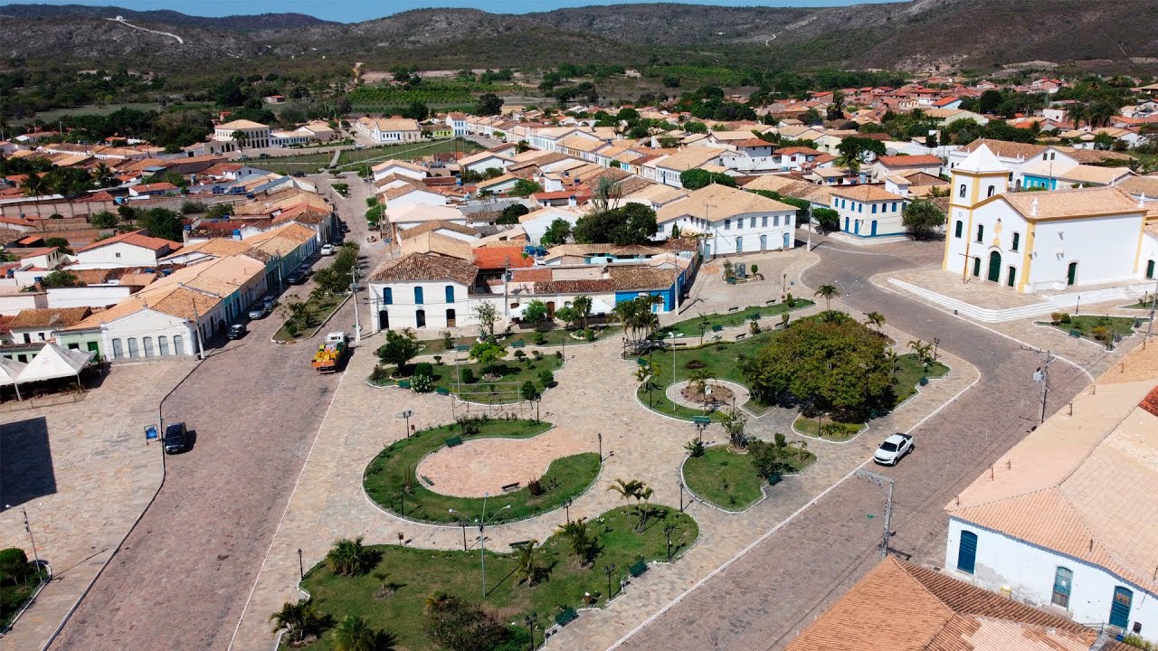
Imagens Aéreas de Rio de Contas na Bahia
History of Rio de Contas
The colonisation of the Rio de Contas region began at the end of the 17th century, when fugitive slaves settled on the left bank of the Contas Pequeno River, where the town of Brumado is today. This place soon became a stop for travellers from Minas Gerais and Goiás on their way to Salvador.
A road linking the São Francisco River Valley to the coast passed through there, encouraging the founding of the village of Creoulos, where a chapel dedicated to Nossa Senhora de Santana was built, the foundations of which were still standing at the beginning of the 20th century.
Up the Brumado River, the São Paulo bandeirante Sebastião Raposo discovered gold in the 1710s, which led to the settlement of Mato Grosso, where the Jesuits, according to tradition, built the Church of Santo Antônio.
In 1715, the same Paulistas founded a new settlement downriver, where they built the Chapel of Nossa Senhora do Livramento.
To control evasion of the quinto (gold tax) and disorder, the Count of Sabugosa commissioned the Bahian explorer Pedro Barbosa Leal to found towns in the region.
Prosperity from mining led to the creation of the Parish of Santo Antônio de Mato Grosso in 1718, the first in the Highlands of Bahia. In 1724, Viceroy Dom Vasco Fernandes commissioned Colonel Pedro Barbosa Leal to found the City of Nossa Senhora do Livramento do Rio de Contas. In 1726 it was made compulsory to set up casting houses in the region.
The discovery of gold attracted bandeirantes from São Paulo and favoured the occupation of this part of the Chapada Diamantina.
In 1745 the town was moved to a new location, called Vila Nova de Nossa Senhora do Livramento e Minas do Rio de Contas, which made it easier to control the alluvial gold mines.
The town’s stagnation began in 1800 with the decline of gold production and worsened in 1844 with the emigration to the newly discovered diamond mines in Mucugê.
The city remained active, however, with the creation of the Casa de Fundição, which led to the development of local jewellery and artisan metallurgy.
The largest collections of quinto occurred after the city was founded, and the municipality, rich in alluvial gold, expanded into the state of Minas Gerais. Despite the decline in production, Rio de Contas remained a stop on the Camino Real, an important route to the Southwest of the São Francisco River Basin and a passage for religious pilgrimages to Bom Jesus da Lapa.
In 1868, the municipality of Vila Velha was created and attached to Vila de Minas do Rio de Contas, which was promoted to town in 1885 and renamed Rio de Contas in 1931.
When the deposits were exhausted, the local economy diversified into handicrafts and coffee, sugar cane, cereals and tuber crops. New gold rushes took place in 1932 and 1939, temporarily reviving mining in the region.
Rio de Contas: Getting to know the history of the city’s formation process
The aim of this article is to analyse the process of formation of the city of Rio de Contas – BA in the 18th and 19th centuries and the regional links that led to the production of the urban network and the territory.
From a methodological point of view, the analyses are based on a bibliographical review to provide a theoretical and conceptual basis, and on documentary research carried out in the IPHAN collections and in the Rio de Contas Municipal Public Archive to gather historical data and maps on the formation of the urban centre.
With the systematised data, it was possible to attest that the city of Rio de Contas had its formation process linked to the colonial context of dependence on the Portuguese Crown, whose main economic activity was gold mining.
In its materiality, Rio de Contas proves to be an important case study for understanding the formation and development of cities in the 18th and 19th centuries in Brazil. The on-site analysis of the historic centre, listed by IPHAN, made it possible to identify the permanence and transformation of the urban form over time.
1. Introduction
The municipality of Rio de Contas, in the state of Bahia, was founded in the mid-18th century, at the height of the gold mining activity in the region, and was the first urban centre, triggering the formation of the surrounding towns. Today the municipality is part of the Chapada Diamantina identity area. Figure 1 shows the location and current boundaries of the municipality of Rio de Contas.
The gold mining and the historical and economic context of the colonisation have left their mark on the urban and rural areas of Rio de Contas. Although tourism promotion activities in the Chapada Diamantina currently focus on the natural environmental heritage, We believe that this work can contribute to the understanding of the formation and development of Rio de Contas in the 18th and 19th centuries and the role of this city in the history of urbanisation in Brazil. The first occupations of the Bahian hinterland are analysed through the advance of colonisation into the interior, with the actions of the Jesuits and Bandeirantes, and the opening of the Royal Road and other roads that increased the flow of people and goods after the discovery of the mines. This approach was essential for understanding the historical processes of the formation of this urban space.

From a methodological point of view, we first prioritised a literature review on the formation of urban centres associated with mining in the colonial period, in order to establish a conceptual theoretical basis. We then collected and analysed data provided by the local IPHAN team and the Rio de Contas Municipal Public Archive. In addition, we collected historical data on the Chapada Diamantina area as a whole and began to sort through materials that would allow us to delimit the urban network in which the city of Rio de Contas – BA is inserted, defining the spatial section of the research.
Based on the data collected, it was also possible to produce cartographic material that helped to understand the territorial evolution and the political and commercial relationships that existed in the regional context of Bahia. Primary data was also collected through fieldwork in the city of Rio de Contas, such as photographic records and on-site observations of the urban landscape. This final stage of the research enabled the permanence and transformation of urban form over time to be analysed.
(1) Municipalities that make up the Chapada Diamantina Identity Territory: Abaíra, Andaraí, Barra da Estiva, Boninal, Bonito, Ibicoara, Ibitiara, Iramaia, Iraquara, Itaetê, Jussiape, Lençóis, Marcionílio Souza, Morro do Chapéu, Mucugê, Nova Redenção, Novo Horizonte, Palmeiras, Piatã, Rio de Contas, Seabra, Souto Soares, Utinga and Wagner (Bahia, 2016).
2. Formation of settlements, parishes and towns in the territory of Rio de Contas
In 1681 there were already movements of flags in the hinterland, which today corresponds to the territory of Rio de Contas. The indigenous peoples who lived there were captured, and others eventually fled to lands unknown to the Portuguese. The bandeirantes therefore had great difficulty in enslaving the native population, and this mobility through the sertões (2) brought about important changes, as Vasconcelos describes:
From a land of Indians, the sertão was transformed into a no-man’s land and a land of the few. The policy of settlement, cattle ranching and mining gave other characteristics to the settlements, complemented by the creation of towns and parishes and the effective implementation of colonial power structures” (2015, p.47).
(2) According to Fonseca (2011), the term sertão was used to designate the regions not yet conquered and explored by the Portuguese in colonial Brazil, and was therefore the dividing line between regions populated by the colonisers and those populated by the indigenous peoples or quilombolas. From the coloniser’s point of view, the sertão represented an unknown interior that could be characterised as a wild and mythical space and, in some cases, as a region that entered the territory and was distant from the coastal zone. The search for gold and precious stones and the need for enslaved labour encouraged the bandeiras and, in some cases, led to the formation of settlements that were the fruit of clearing these hinterlands.
The Jesuits played a leading role in the process of “docilisation” and exploitation of the labour of the native peoples, who were seen by the colonisers as friendly and possessing strategic knowledge of the territory. The religious arrived peacefully in the villages and, through their faith, gained the trust of the natives and their allegiance to the colonisers’ aims. Because they knew the territory well, the indigenous people made it possible to expand the area explored by the bandeirantes.
The colonisation of the area in question began at the end of the 17th century, when fugitive slaves settled on the left bank of the Contas Pequeno River (now known as the Brumado River, a tributary of the Contas River) and founded the settlement of Creoulos (3). It soon became a stopover for travellers from Minas Gerais and Goiás on their way to Salvador along the road that passed through there. A chapel was built there under the invocation of Nossa Senhora de Santana, the ruins of which remained until the beginning of the 20th century (IPHAN, 2023).
(3) The site of the settlement of Creoulos now corresponds to the city of Brumado – BA.
Going up the Brumado River, Sebastião Raposo from São Paulo discovered gold in the 1710s and near these mines the arraial of Mato Grosso was founded, where, according to tradition, the Jesuits built the Chapel of Santo Antônio. The arraiais were initially characterised as temporary resting-places, used as camps when mines were found for exploration. In time they took the form of villages. In the 18th century, the term “arraial” took on the meaning of settlement in the mining areas of the colony, and was sometimes ephemeral in nature, as miners sought the easiest way to exploit gold, near streams and rivers (Fonseca, 2011). The village of Mato Grosso grew as a result of mining, and in 1718 the Parish of Santo Antônio de Mato Grosso was created, the first in the Highlands of Bahia.
During the colonial period, the patronage system was in force throughout the Portuguese Empire. In this way, the policy of colonisation was linked to the presence of the Catholic Church in the creation of new urban centres. The acquisition of sesmarias was linked to the donation of parts of these lands for the constitution of the patrimony of chapels. In turn, the formation of urban centres respected the regulations of the Portuguese Crown, but the construction of chapels and parish churches also had to obey the rules of the Church (Fonseca, 2011). In the mining areas, the presence of the Catholic Church also served to support the application of the laws established in the territory by the Portuguese Crown, defending the sharing of wealth through the payment of tithes in order to achieve eternal salvation. The principles defended by the Church helped to minimise the high rate of smuggling associated with the production of wealth, as the population feared not only the sanctions of the law, but also the divine punishments preached in the services.
The Paulistas also founded another settlement in 1715, 12 kilometres downstream from the town of Creoulos, where the Jesuits built a chapel dedicated to Our Lady of Livramento. The discovery of mines encouraged the colonisation of this part of the plateau, and on 31 October 1721 a Royal Charter was issued allowing the exploitation of minerals in the region. As a way of controlling disorder and preventing the evasion of mineral wealth and the taxes levied by Portugal on the gold extracted, the then Viceroy of Brazil, Vasco Fernandes César de Meneses (4), commissioned the Bahian explorer Pedro Barbosa Leal to found cities in the region. In 1724, the settlement next to the chapel was promoted to the town of Nossa Senhora do Livramento do Rio de Contas (Pereira, 1940).
(4) Vasco Fernandes César de Meneses, 1st Count of Sabugosa, was Viceroy of Brazil from 1720 to 1735. During his reign, he built forts, strengthened settlement and controlled the regions where there was gold.
In the same year, 1724, the Count of Galveas (5) settled in what is now the town of Minas do Rio de Contas. On this occasion, by order of Archbishop José Botelho de Matos, the Parish of Santo Antônio de Mato Grosso was changed to the invocation of the Blessed Sacrament of Minas do Rio das Contas, with the order to remove the chapel‘s objects and goods (Pereira, 1940, pp. 44-45).
(5) The 4th Count of Galveias, André de Melo e Castro, was a Portuguese Crown official and colonial administrator, also known for his diplomatic missions. His work was marked by important political and administrative commitments in the context of colonial Brazil. According to Mendes and Castro (2008), he was part of the elite of governors general and viceroys who worked in Brazil, who exercised significant influence on the administration and sociopolitical formation of the Portuguese Empire overseas, especially between 1647 and 1750.
Due to the need to control the alluvial gold mines more effectively and closely, the colonial administration decided to change the location of the city. Thus, in 1745, the old town was moved to the new site, called Vila do Santíssimo Sacramento do Rio das Contas. Added to this was the precariousness of Vila Velha, as it was initially populated spontaneously and was very close to the watercourses, which made the population vulnerable during periods of flooding.
The conclusion was that the claim of the miners was true, as the village was far from the town and they had difficulties travelling, especially in winter, as well as being far from the officials to deal with issues that affected them or related to the interests of the Royal Treasury (Vasconcelos, 2015, p.100).
This historical fact of the change in the location of the city makes it easier to understand the current outline of the territory and the connections between Rio de Contas and the other cities. The distance from Vila Velha to the new Vila de Minas do Rio de Contas is currently 11.9 kilometres.
Analysing these developments in Rio de Contas, it can be seen that as the urban site changed, new buildings were constructed to meet the needs of the local population, These include the Church of Nossa Senhora Sant’Ana and the Church of Santíssimo Sacramento, which is now the city parish church.
By August 1746, the new town had already built about 30 houses and a church, under the invocation of Senhora Sant’Ana – built with alms from the faithful – and a hospital, which, according to the ombudsman of the southern district […Moreover, the inhabitants had already organised the Brotherhood of Senhora Sant’Ana, and the Ombudsman asked the royal authorities to approve its statutes and to sanction the church and hospital built on the new site of the village of Nossa Senhora do Livramento das Minas do Rio de Contas (Almeida, 2012, p.36).).
In analysing the organisation of Portuguese colonial cities, it is essential to highlight the distinction between the upper city and the lower city, urban concepts applied in colonial occupations. This division refers to the theories of urban occupation of the time and the influences of Spanish Cartesian models, especially in the gold regions, which sought to establish an urban structure with a hierarchical logic.
These ideas show how Portuguese urban planning was different, adapting to the terrain and organising administrative and religious spaces at strategic points in the city. The upper city was often located in elevated areas, offering protection and wide visibility, while the lower city was developed in lower regions, favouring trade and daily interaction. This structuring reflected not only the desire for territorial control, but also the intention to consolidate the presence and authority of the Portuguese Crown in the new lands.
The urban layout reflected the organisation of the city, which was being planned(6) at the time. In the allocation of the main public buildings and the choice of the location of the parish church, priority was given to the presence of squares or open fields in order to highlight them, and, as usual, in accordance with the Constitutions of the Archbishopric of Bahia, the Catholic Temple was built on higher ground to give it visibility and to demonstrate the power of the Church in shaping the urban space and the settlement process.
(6) Contemporary theories about the Portuguese colonial urban occupation should be highlighted here – the concept of settlement. the concept of the lower city and the upper city, and the influence of the Spanish Cartesian projects in the gold mining centres (opinion piece for the Labor & Engenho Editorial Team).
The Portuguese Crown developed a strategy for the establishment of cities in, in which it ensured the existence of main streets and the separation of a square focused on administrative logistics and another focused on religious matters, with the allocation of the church. Pessotti & Ribeiro (2011), in examining this strategy in Brazilian urban foundations, conclude that:
[…The eighteenth century and the multiple Brazilian urban foundations of this period are characterised by a growing affirmation of regularity and orthogonality, by the assumption of squares as generating elements of urban networks, and by the adoption of uniform architectural programmes that would be reflected in eighteenth-century Portuguese urban planning practice and theory. […] Among the determining factors in the structuring of Portuguese cities, the geography and topography of the land, the climate, the nature of the soil and the materials available for construction played a fundamental role” (pp.151-152).
Urban Planning is directly related to the intervention of the state/government in the construction of cities. Where there is no such involvement, urban agglomerations develop without symmetry and the demand for private investment prevails (Texeira, 1999). There were two accepted ways of thinking about a city: the first and simplest was the vernacular urban layout, the highest, designed to protect the territory with a wide view. Another type of urban layout is the erudite, which is executed with a regular layout based on idealisations of straight lines and geometric components, with the presence of technicians responsible for drawing this model. Pessotti & Ribeiro (2011, p.153) address this issue: which follows the natural path of the topography, taking as an example the cities of Portuguese influence, which are located at the highest point, designed to protect the territory with a wide view. Another type of urban implantation is the erudite, executed with a regular layout based on idealisations of straight lines and geometric components, with the presence of responsible technicians in the elaboration of this model. Pessotti & Ribeiro (2011, p.153) address this issue:
The Portuguese city is always planned and built with the location, taking into account its physical and environmental characteristics. Even in cases where the plans were based on geometric principles and where the physical characteristics of the area could be considered less relevant, there has always been a concern to adapt the plan and its geometry to the pre-existing features, whether natural or man-made. The Portuguese city is characterised by the synthesis of these two components, the intelligent harmonisation of these two ways of building the city, which is the main characteristic of Portuguese urbanism.
It was most common to merge these two models because in some places it was difficult to follow the orthogonal layout due to the rugged topography. In addition, there wasn’t always enough skilled labour to organise the urban space, and technicians were often only available in the wealthier parts of the colonies (Pessotti & Ribeiro, 2011). According to Teixeira:
The cities built by the Portuguese outside Europe are the result of a variety of influences and reference models, both vernacular and erudite, from different historical moments. Each city showed a particular synthesis of traditional and erudite elements, depending on the time it was built, its development or not from other pre-existing urban complexes, and the different attitudes and political strategies that had led to its foundation. In most cases, the Portuguese urban structures built in the context of overseas expansion do not correspond to pure types of layout, and we see urban patterns of vernacular or medieval origin synthesised with Renaissance ideas” (1999, p.215-216).
In the historiography of the city under study there is evidence of the formation of a settlement which soon underwent a process of change of urban site, and this new site, the subject of this study, had in practice all the influence of a government concerned with the organisation of the city. Studying the formation of the urban layout in the 18th century, Pessotti & Ribeiro (2011, p.162) point out:
In the eighteenth century, many towns and cities were built in Brazil with absolutely regular and geometric plans, most often orthogonal, where the great themes of classical urbanism are expressed. These urban centres were planned rationally, with an overarching structure, and the square took on the role of the heart of the urban fabric. The beauty of the city was associated with the regularity of the layout and the adoption of uniform architectural models to which all buildings in a street or square, or even the entire urban centre, had to conform.
The characterisation of the urban space by the opinion of the Cultural Heritage Advisory Council: historic cities, urban and architectural ensembles, describes this area of analysis and its listed urban site well (see Figures 2, 3, 4 and 5):
The town of Minas do Rio de Contas, located on the left bank of the Brumado River, formerly the Rio de Contas Pequeno, and cut by two small streams, was created as a result of mining. It consists of only six streets, two squares, two churches, a typical 18th century town hall and prison, three or four mansions and houses with “doors and windows” (Reis Filho & Finger, 2016, p.89).

Figure 2 – Photo of Praça Senador Tanajura: Igreja Matriz do Santíssimo Sacramento: Rio de Contas, BA (s./d.). Source: IBGE online library. Accessed 14 November 2022.

Pictures 3, 4 and 5. Set of houses belonging to the listed urban site in Rio de Contas – BA, 2022. Photo: Letícia Coêlho de Oliveira. “On this scale you can see a typical colonial layout, in which the streets, blocks and plots are defined based on the marking of the main squares“(Oliveira, 2023, p.143).
In the colonial period, the construction of the Royal Roads, which were intended to link Bahia with Goiás, was decisive for the settlement and constitution of urban centres in the region under study, such as the Municipalities of Jacobina and Rio de Contas. The boundaries of the parishes of Jacobina and Rio de Contas were linked to the courses of the rivers and the royal roads along which the goods produced in the region were transported. The economic and political weight of the comarcas meant that they played an important role in the Portuguese Crown’s strategies to control and expand its territories. According to Vasconcelos, in the comarcas:
There was a specific administrative structure whose occupants had authority and power independent of the general government, including the possibility of communicating directly with the king and his representatives in the Overseas Council. This characteristic of the Mining Administration was primarily intended to guarantee the policy of taxation, an ingenious formula of the Portuguese Crown, which, in view of the migratory mining activity, delegated exploration to private individuals, along with investments in material and slave labour, benefiting from the surcharges le levied on all activities and products” (2015, p.32).
Figure 6 highlights the probable route of the royal road that ran along the Paraguaçu River and its tributaries, demonstrating the historical relationship between roads and drivers, which allowed the development of Jacobina and Rio de Contas. The road connects the Territories, now cities, which form part of the Chapada Diamantina-BA region. The red line shows the route that starts in the municipality of Jacobina, then Morro do Chapéu, then Lençóis, Andaraí (then Iguatú district of this municipality), Santa Isabel do Paraguasu, which today corresponds to Mucugê, until finally reaching Rio de Contas.


Figure 6. Province of Bahia and the course of the Paraguassú River Road, undated. Sources: MAP OF THE PROVINCE OF BAHIA showing the course of the Paraguassú road.
The roads were fundamental for the articulation of the counties in Bahia and served to connect the colonial territory. As such, the Portuguese Crown’s main routes facilitated the conquest of new areas that had not yet been explored and the settlement of the population and the first cultivation of land. Studies carried out by Vasconcelos show that:
The auriferous region of Bahia was a point of convergence and intersection of roads already opened and yet to be opened, articulated with different regions: the North (Piauí and Maranhão – the latter opened in 1698 by D. João de Lencastro); Northeast (Sergipe, then part of the Captaincy of Bahia, Pernambuco, Paraíba and Ceará); Centre-South (Minas Gerais, Goiás, Mato Grosso; Espírito Santo and Rio de Janeiro). (2015, p.79).
The development of the Comarcas of Jacobina and Rio de Contas was articulated with the rest of the territory of the interior of Bahia, which, from the beginning of the 18th century, had the function of supplying supplying Minas Gerais. Even with the discovery of gold in the region, which includes the territories of Jacobina and Rio de Contas, the Portuguese Crown administration suspended its exploitation until the mid-1720s in order to prioritise supplies to Minas Gerais, where mining was already important. The defence of the territory of Bahia was also necessary, due to the constant invasions by the Dutch. Vasconcelos ponders:
Capistrano de Abreu maintains the same justification for the ban – the real fears of foreign invasion. If the absence of gold mining in Bahia is true, it was short lived in Goiás. In the 18th century, Bahia was as agricultural and pastoral as it was mining (2015, p.73).
In the 18th and early 19th centuries, Bahia was responsible for the production of flour, tobacco, sugar cane and cattle, which directly supplied the regions of Minas Gerais, but also the foreign market(Lins & Santana, 2017). If we look at the municipality of Rio de Contas, we can see that agriculture was the pioneering activity, which later, with the discovery of gold, became even more important as it fed the large population that settled there in search of mineral wealth. Due to its strategic location, Rio de Contas served as a passageway, being the shortest route to Minas Gerais, as well as a post for inspecting and taxing the gold collected. In this urban centre, buildings were constructed to support the flow of production and the administrative work of the Portuguese Crown.
In this context, another force that was widely used was enslaved African labour. With little knowledge of the country and a mixture of people from different parts of the African continent, it was easier to enslave them. In addition, the enslaved had more technical knowledge to deal with mining (Kok, 2004). The intensive use of enslaved labour in mining created a population composed mainly of African descendants, not only in Rio de Contas but throughout the Chapada Diamantina. This reality will later justify the presence of many quilombos in this urban network, as a result of the escapes of the enslaved.
Some of the urban sites that make up this network have their origins in the quilombos, which settled there at the height of the gold cycle. The relationship between the remaining quilombola, communities and the country still exists today in the rural areas of the municipality of Rio de Contas – BA, such as the municipalities of Barra and Bananal. In the Quilombola Territories, the cultural expressions of Afro-descendants can still be observed, be it in the way they celebrate, the typical foods or even the construction techniques that are reflected in the architecture(Lins & Santana, 2017).
Examining the process of the formation of urban centres and the changes in their status, from arraiais to cities, shows the constitution of a network permeated by disputes over political and economic power. In this sense, a hierarchy will soon be established between the urban centres that make up the Chapada Diamantina network. Economic activities and political weight have given these locations varying degrees of importance over time.
In the first settlement, the centre of the Minas de Rio de Contas, known as Vila Velha, the occupation process took place spontaneously, in order to quickly satisfy the mining demand. This phase was also characterised by the presence of supply farms, so that the small urban centre functioned as a support for the surrounding residents.
An understanding of the formation process of Minas de Rio de Contas was based on an analysis of textual documents and historical cartographies from the period covering the mid 18th and early 19th centuries. In the area corresponding to the original town of Minas de Rio de Contas, a regional urban network was established with the discovery of diamonds between 1817 and 1818, reaching its peak of exploitation in 1844. As the following extract from Theodoro Sampaio‘s travel diary makes clear, the site of the discovery was the focus of attention:
It was at this place that the presence of the diamond in the auriferous gravel was probably signalled for the first time in these hinterlands, since there, at the headwaters of the Rio de Contas, the formation of the terrain is as auriferous as it is diamondiferous. However, according to tradition, the first discovery of diamonds on the plateau did not take place until 1817 or 1818, when Captain Major Felix Ribeiro de Novaes, who was exploring the Serra do Gagau, managed to collect some of these precious stones, which he presented to Colonel Joaquim Pereira de Castro, but kept secret because mining was forbidden at the time”. (Santana, 2002, p.258).
On an expedition to the Province of Bahia in mid-1879, Theodoro Sampaio produced a series of maps and drawings showing what the Chapada Diamantina area looked like at the end of the 19th century. This is fundamental material for understanding the articulation of the existing urban networks. The maps he produced show the gold and diamond mining sites and the roads used for exploration. The farms that supplied the region are also shown, as are the features of the relief and the names of the peaks.
Figure 7 shows a map drawn by Theodoro Sampaio, which shows more clearly the distance between Vila Velha and Minas do Rio de Contas. The drawing also shows the rivers and the mountainous terrain, as well as the gold exploration areas and their respective boundaries: Pico de Mato Grosso, Minas de Rio de Contas and Vila Velha. There is a mountain wall between the areas of the two municipalities, connecting Pico das Almas with Serra da Villa Velha.

Figure 7. Cartographic representation of the area in which Vila Velha and Minas de Rio de Contas are located, made by Theodoro Sampaio on an expedition to Bahia in mid-1879. Source: IGHB – BA Archive.
3. Transformations in the colonial urban space of Bahia and Minas de Rio de Contas
The development of the urban centre was marked by numerous transformations in order to accommodate the political and economic interests of the Portuguese Crown. Thus, the way in which the new urban centre was structured seems very similar to the urban morphology of other 18th-century Portuguese-Brazilian cities, if one looks at characteristics such as the division of plots, the layout of the streets and the arrangement of the town centre, with the presence of the parish church and public buildings strategically placed there. Pessotti and Ribeiro (2011, p. 76), in their study of colonial cities in Bahia, reveal how this procedure was carried out and the agents who made this urban organisation possible:
The ombudsman summoned the inhabitants of the town and the neighbouring villages by public notice to stand in front of the houses of their retirement on the exact day, from seven to eight o’clock in the morning, to accompany him in the act. Everyone went to the cleaned and measured place, the square with the streets already laid out and prepared with arches and festive decorations, where the ombudsman raised the pillory and acclaimed the city.
This strategy of urban occupation confirms the Portuguese Crown’s desire to organise them according to its interests, seeking an urban quality that is still reflected today in the peculiarities of these historic urban centres.
The layout of squares, streets and lanes and their measures were “well explained, individually with their names” in the book of provimentos da correição. Needle makers and Rope makers, as well as Bush pickers, all of whom lived in the area, were appointed to take the measurements. They had to present their measurements, needle and rope for the minister to check that they were correct and within the standard (Pessotti & Ribeiro, 2011, p. 76).
This type of change had a direct impact on the urban layout that can still be seen today in the urban sites of colonial Brazil, and Rio de Contas is no different. The decisions made at the general level of the colony had an impact on the new spaces built, as did the move of the capital from Salvador to Rio de Janeiro. The Marquis of Pombal (7) was an important agent in shaping the urban space of colonial Brazil, since his actions had a general impact on the territory. According to Pombal’s vision for Brazil, the royal authority was to be extended by increasing the number of cities in the interior of the colony and integrating them into a programme designed to take advantage of the potential of the territories (Delson, 1997, p. 49).
(7) With the death of Dom João V in 1750, Dom José I ascended the Portuguese throne, preferring to leave control of politics in the hands of his prime minister, Sebastião José de Carvalho e Melo, the Marquis of Pombal, who de facto ruled the nation and its overseas empire until 1777. The Marquis undertook his administrative duties with the reformist zeal characteristic of the eighteenth-century proponents of the Enlightenment (Delson, 1997, p.49).
[…] Within the framework of these actions of the Pombaline Project, urban centres, more precisely villages, were created in order to bind the inhabitants to the land. The creation of these cities was therefore part of a broad political programme. It was not an isolated event, nor was it directed solely at Brazil” (Pessotti & Ribeiro, 2011, pp. 69-70).
Pombal’s objectives for Brazil were to consolidate the occupation of the territory and unify it, coinciding with the period in which the gold mines began to decline. It was therefore necessary to look for other ways to gain wealth. During the Pombal period, in addition to the founding of new towns, the Portuguese administrators were urged to civilise the localities. The recommendations for transforming the existing urban centres included the adoption of a regular urban layout according to the customary model so that the place would take on “the characteristics of a well-established village” (Delson, 1997, p. 53).
The movement of the capital from Salvador to Rio de Janeiro and the events that took place during the period of the Pombaline interventions had their positive and negative points for the territory of Bahia, more specifically, for Rio de Contas, which at the time was classified as a village. A positive aspect was the unification of the captaincies with the centralisation of orders and demands by the Captaincy of Bahia.
Within this Portuguese project, the Captaincy of Bahia stands out. Although it lost its position as the capital of the Viceroyalty, the former captaincies of Ilhéus and Porto Seguro were incorporated into its territory. It also included part of the Northern Espírito Santo Captaincy and the whole of Sergipe. Comarca and Ombudsman Positions were created, and Bahia now had, in addition to the Comarca of the South, or Jacobina, and that of the North or Sergipe, those of Ilhéus, Porto Seguro and Bahia proper, some of which were created at that time (Pessotti & Ribeiro, 2011, p. 72).
The lack of labour for the Bahian mines would create the danger of attracting people from Minas Gerais, depleting this captaincy and driving the Bahians away from exploration. The migration of labour was a disorder that was difficult to contain and meant that extraction could not be concentrated in the two captaincies.
The economic and political events that took place in Brazil during the colonial period had a direct impact on the dynamics of activities in the Minas de Rio de Contas, with repercussions on the circulation of people and goods, as well as on external relations. The mining of gold generated an intense flow of people and attracted a large population, which meant that the urban fabric had to be modified to meet the demand, with significant changes to the urban layout. However, with the reorganisation of mining production due to the discovery of other gold regions and new relationships with the Portuguese Crown, a contingent of administrators moved to the new capital and many workers went to Minas Gerais and Goiás, attracted by the work in the gold mines. In this way, the expansion and retraction of mining activities brought about changes not only in the urban centre of Minas de Rio de Contas, but also in the relationships established with other urban centres.
4. The formation of the urban network of Vila de Minas de Rio de Contas
As well as being the seat of administrative power and the control of the mineral wealth, its links with the farms and surrounding regions made Minas de Rio de Contas a regionally influential urban centre. In 1843, at the height of the diamond mining boom, the town of Minas do Rio de Contas had a vast area, comprising several arraiais and settlements connected by roads. Over time, these urban centres, included in the Minas do Rio de Contas settlement, developed and broke up, giving rise to other municipalities in Bahia.
The map in Figure 8 shows the life of the town of Minas de Rio de Contas and the vast territory under its control and power. It is clear that the settlement process mainly followed the course of the Rio de Contas and the other tributaries of its hydrographic basin, from the coast to the interior of Bahia.

Figure 8. Map of the town of Minas de Rio de Contas, 1843. Source: Almeida (2012, p.34).
The territory was so vast that 81 municipalities known today belonged to the Vila de Minas de Rio de Contas in the 19th century. The territory was so vast that it included the centre and south-west of Bahia, as far as a coastal area in the town now known as Itacaré. Over the years, the territory was divided between 1724 and 1962.
The importance of Villa de Minas de Rio de Contas was fundamental to the formation of the urban network in this area, based on mining and agricultural production. From a broader perspective, the region was connected to the Royal Road, which was fundamental in supporting regional development: “Minas do Rio de Contas was therefore the axis of the progressive and cultural development of the various settlements that formed around the town, and of the progress of gold mining” (Pereira, 1940, p.26).
Figure 9 shows the territorial connections made possible by the opening of the Royal Road.

Caption:
- Paraguassú River
- Santa Isabel
- Mucugê
- Serra do Sincorá
- Geraes (quartzite)
- Lapa da Maxambomba
- Gavião Peak
- New World
Figure 9. Royal Road. From S. Isabel to the Royal Road of Geguy, 1879. Source: Map drawn by Theodoro Sampaio on his Expedition to Bahia in 1879. Archive of the IGHB – BA.
Figure 10 shows the connection between Jacobina and the territory of Rio de Contas, which was due to the flow of taxes, the transport of gold and food produced in the region, linking the exploration area of Minas Gerais with the captaincy of Bahia. In addition to the roads that were opened near the riverbeds, the area was assigned the royal road, which today corresponds to thirteen municipalities that connect Rio de Contas and Jacobina. Arraes (2017, p. 23) describes how information was obtained and the process of forming the network was planned during the colonial period:
‘Gathered at the seat of the captaincy’s government, Captain General Antônio de Albuquerque Coelho de Carvalho listened attentively to the news from Bahia and the areas the magistrate travelled along the road that would later be named the Royal Cattle Trail.’ The ease of communication and the shortened journey appear in the ombudsman’s narrative. […The records of passages, missions, chapels, parishes, towns and cities formed the structuring “nodes” of the route, but their existence required the emergence of other routes and new human settlements, transforming this land line into one of the threads of a warp and woof.
It was with the opening of these royal passageways that the Rio de Contas region developed, becoming not only a place of access but also a region that received inspection mechanisms from the Portuguese Crown and established trade relations with other regions.
Figure 10 shows the composition of the landscape, in which the natural scenery mixes with the constructed buildings, allowing us to visualise the urban centre of Villa Velha from the angle of the south side, and how it was laid out in 1879. This landscape has changed over time, but there are permanent features, such as the striking presence of the Brumado Waterfall and its Mountain Range. Today, the BA-148 Ecological Road connects the municipalities of Rio de Contas – BA and Livramento de Nossa Senhora, which was the former village of Vila Velha, offering views of the Cachoeira do Brumado.

Figure 10. Vila Velha seen from the south, Cachoeira do Brumado drawing by Theodoro Sampaio, 1879 on the Bahia Expedition. Source: IGHB – BA Archive.
Some of the buildings that made up Vila Velha are very similar to those of Vila da Minas de Rio de Contas. It can be said that the Portuguese Crown developed architectural types that guided the construction of buildings associated with the administration. The City Hall and Prison stand out in this image, in the centre of the sketch, as does the Waterfall of the River Brumado, which still stands out in the urban landscape and is known as the Véu de Noiva Waterfall.
Figure 11 shows the Map of the Diamantino District of S. Isabel do Paraguassú, also drawn by Theodoro Sampaio. The diamond mines were located in this area and the plan shows the paths followed to reach these villages. Sampaio demarcates the paths by marking the waterfalls and bridges built over the rivers of the area, which cross the tributaries of the Rio Negro and the Rio Preto do Sincorá.
Access to the mines was precarious, in most cases built with ephemeral materials, such as wooden bridges, which were usually located on routes that passed the waterfalls. Thus, over the centuries, this evidence of the connection between the mines and the villages was lost, which explains the few traces of access passages to the mining areas (Vasconcelos, 2015).
The farms were important points of passage or access to the mines. Many of them are listed, such as Fazenda das Laranjeiras and Fazenda Gameleira. The set of sketches and maps by Theodoro Sampaio provides important clues to understanding the process of the formation of the urban network of Villa de Minas de Rio de Contas by delineating the territorial elements that made it possible to establish connections between places, such as roads, farms, mining areas, crossing points, among others.

Figure 11. Plan of the Diamantino district of S. Isabel do Paraguassú. Drawn by Theodoro Sampaio on his expedition to Bahia in 1879. Minas da Siberia. Source: IGHB – BA Archive.
5. Concluding considerations
The urban reorganisation that followed the relocation of the urban core was the result of the application of the technical knowledge available at the time, as well as the intentions and objectives of the Portuguese Crown. Socio-economic interests played a crucial role in this process of (re)structuring the regional urban space. It was essential to create favourable conditions for the extraction of precious metals, the smelting of ingots and the transport of these goods, as well as ensuring the supervision of production, with the aim of accumulating wealth for both the local elite and the colonisers.
During the colonial period, this urban area was articulated with the other localities in its urban network as a strategy to make the demands of the gold economy viable, but over the years its regional influence was reduced as the economic dynamics changed due to the mining crisis, and as a result it lost political control of the territory.
Due to the decline in gold production and then the food crisis, it was the migration to the cities that contradictorily contributed to the preservation of the community’s historical heritage, since there was no immediate economic development project requiring the replacement of previous structures. What’s more, with the listing of the urban area in the 1980s, the development of awareness of architectural heritage conservation, the public maintenance of some buildings and the constant monitoring of the listed urban heritage, buildings were not de-characterised or destroyed.
Nowadays, the connection between the municipalities that developed in the former term of Vila de Minas de Rio de Contas is through tourism, agricultural production links and the sharing of road infrastructure for the flow of products and people, and, of course, the sharing of some manifestations of popular culture.
6. References
-
- Almeida, K. L. N. (2012). Alforrias em Rio de Contas-Bahia: século XIX. Salvador: Edufba.
- Arraes, D. E. A. (2017). Echoes of a supposed silence: landscape and urbanisation in the hinterlands of the North, c. 1666-1820. Doctoral thesis. University of São Paulo.
- Bahia (2016). Territorial Plan for Sustainable Rural Development and Solidarity in the Chapada Diamantina Territory. Salvador.
- Conceição, Hélida Santos (2020). The trajectory of Pedro Barbosa Leal and the networks of conquest in the hinterland of the Captaincy of Bahia, 1690-1730. Rio de Janeiro: Maracanan, n. 25, pp. 74-102.
- Delson, R. M. (1997). New cities for colonial Brazil. Spatial and social planning in the 18th century. Brasília: Ed. ALVA-CIORD.
- Fonseca, C. D. (2011). Arraiais e vilas d’El Rei – space and power in 18th century Minas. Belo Horizonte: UFMG Publishing House.
- IBGE (2021). Occupied population. IBGE, Central Business Register. 01 July 2021. IBGE.
- IPHAN (2023). History of Rio de Contas, material heritage, listed urban complexes. 21 Aug. 2023. IPHAN.
- Kok, G. (2004). O sertão itinerante: expedições da capitania de São Paulo no século XVIII. São Paulo: Hucitec.
- Lins, E., & Santana, M. (2017). Masters and artisans-Bahia: Notebook of Memories. Salvador: Halley.
- Mendes, C. G., & Castro, J. H. F. de (2008). Brazil in the Portuguese overseas empire and the study of the socio-political trajectories of the governors general and viceroys of Brazil between 1647-1750. In: Proceedings of the 2nd LAHES Colloquium: Microhistory and the paths of social history.
- Oliveira, L. C. (2023). Urban networks and a view of the city of Rio das Contas – BA in the 18th and 19th centuries. Master’s thesis. Pontifical Catholic University of Campinas, Postgraduate Course in Architecture and Urbanism, Campinas, SP, Brazil.
- Pereira, G. de A. (1940). Minas do Rio das Contas. Bahia: s./e.
- Pessotti, L., & Ribeiro, N. P. (2011). The construction of the Portuguese city in America. Rio de Janeiro: PoD.
- Reis, N. G., & Finger, A. E. (2016). Opinions of the Cultural Heritage Advisory Board: historic cities, urban and architectural ensembles. Brasília: Iphan.
- Santana, J. C. B. (2002). The São Francisco River and the Chapada Diamantina (Teodoro Sampaio). São Paulo: Companhia das Letras.
- Teixeira, M. C. (2012). The form of the city of Portuguese origin. São Paulo: Editora Unesp.
- Vasconcelos, A. L. (2015). As Vilas do Ouro: society and labour in the slave mining economy (Bahia, 18th century). Vitória da Conquista: Edições UESB.
Publicações Relacionadas
The highest and most beautiful waterfalls in Chapada Diamantina
Piatã: The Highest Municipality in Bahia
Campo Formoso: Explore Caves and Emerald Trade
Trekking in the Pati Valley in Chapada Diamantina
Mucugê: Discover the local history and culture
Main caves in the municipality of Iraquara in Chapada Diamantina
Sempre-Viva: Symbol of Preservation in the Chapada Diamantina
Tourist Attractions and Documentaries about Chapada Diamantina
Ventura Village: A Rich History of Diamonds
Ecological tourism in Morro do Chapéu
Trekking - Popular trails in Chapada Diamantina
Main Towns and Villages in the Chapada Diamantina Region
History of the settlement of Chapada Diamantina
Dive Sites of Chapada Diamantina: A Guide
Tourist Attractions in Rio de Contas You Must Visit
Trail to Buracão Waterfall in Chapada Diamantina
Marimbus Pantanal: Adventure in Chapada Diamantina
Tourist Information about Chapada Diamantina
Picos das Almas, Itobira and Barbado Trekking Guide
Palmeiras: A Gateway to Chapada Diamantina
Ibicoara: An Unmissable Tourist Destination
Things to do in Lençóis in the Chapada Diamantina — 15 attractions
Trekking in the Pati Valley in Chapada Diamantina
Rio de Contas: An Unmissable Tourist Destination
Chapada Diamantina - Tourist Attractions, Itineraries and Tips
How to get to Fumaça Waterfall in Chapada Diamantina
Enchanted fountain in Chapada Diamantina: How to get there
Waterfalls of Chapada Diamantina: A Guide for Adventurers
Birds Found in Chapada Diamantina: A Guide
Andaraí is the second largest town in the Chapada Diamantina
Mining in the Chapada Diamantina History Explained
Curiosities about the Rio de Contas in Chapada Diamantina
Relief, Fauna and Flora of Chapada Diamantina
Lapão Cave: The Ultimate Adventure Experience
Blue Fountain in Chapada Diamantina: a complete guide
Chapada Diamantina's architectural style and influences
This post is also on:
![]() Português
Português ![]() English
English ![]() Deutsch
Deutsch ![]() Español
Español ![]() Français
Français


