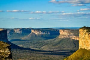
The Chapada Diamantina is a mountainous region in the centre of the state of Bahia, where almost all the rivers of the Paraguaçu, Jacuípe and Rio de Contas basins originate.
These watercourses spring from the peaks, flow down the slopes in beautiful streams, plunge into bubbling waterfalls and form transparent natural pools.

National Park and Biodiversity
The Chapada Diamantina National Park is managed by the Chico Mendes Institute for Biodiversity Conservation (ICMBio). The region is rich in lush vegetation, composed of species from the semi-arid caatinga and mountain flora, with highlights including
- Bromeliads,
- Orchids,
- Everlasting flowers.
Main attractions
The Chapada offers a variety of attractions that will make you amazed and ecstatic, such as
- Fumaça Waterfall: With a 380-metre free fall, it is the highest waterfall in Bahia.
- Poço Encantado: One of the most stunning sights in the region.
Other activities include:
- Visiting caves;
- Swim in waterfalls;
- Trekking on old gold mining trails;
- Ride a horse;
- Practice adventure sports.
Communities and highlights
The Chapada Diamantina is home to esoteric and alternative communities, such as in Vale do Capão. The two highest points in Bahia are located in the region:
- Pico do Barbado: At 2,033 metres, this is the highest point in the northeast.
- Pico das Almas: At 1,958 metres.
A unique experience for tourists
Walking, breathing fresh air and admiring the landscape are the main activities for tourists visiting the Chapada. The green places hide surprises such as
- Crystal clear water;
- Coloured sand;
- Beautiful hills, flowers and vegetables that enchant with their beauty and vitality.
Igatu and its ruins
At Igatu, visitors are fascinated by the ruins of the ghost town, built with stones that form the walls of small caves.
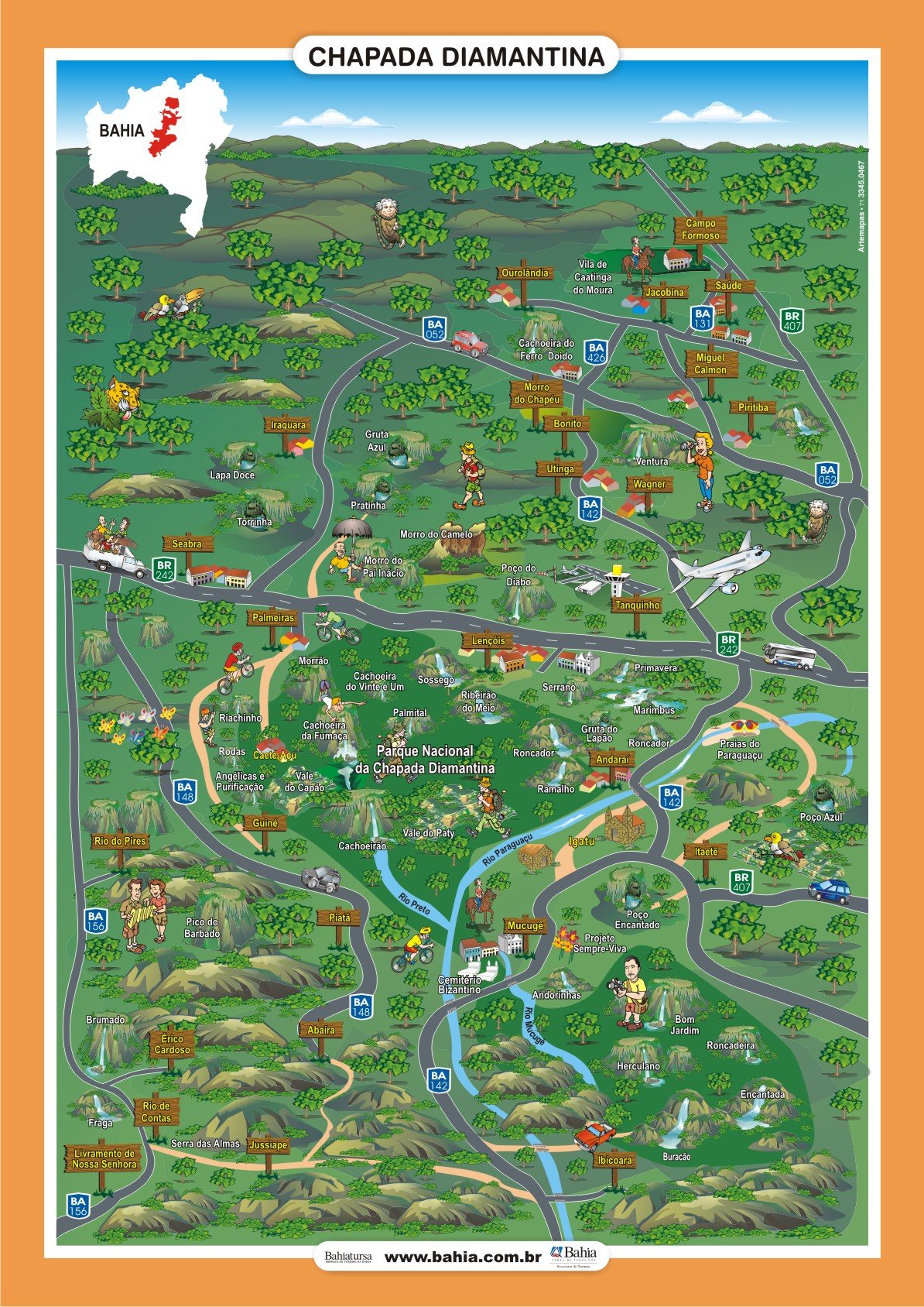
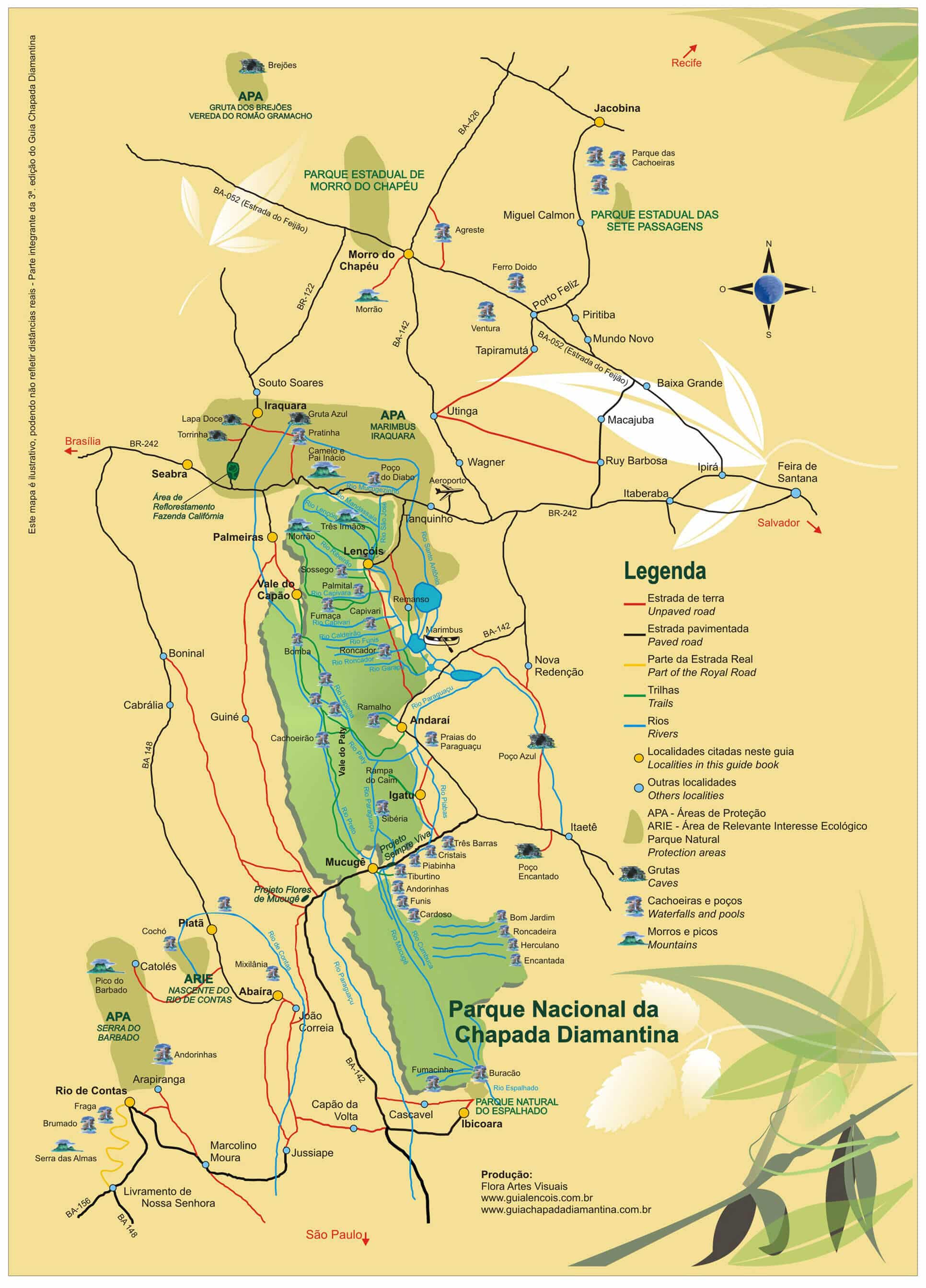
See the map of Chapada Diamantina
Map of trails and points of interest in Chapada Diamantina
See also Geography and Climate Regions of the Northeast
Videos about Chapada Diamantina relief, flora and fauna

Resumo sobre a Chapada Diamantina09:48

Geografia da Chapada Diamantina03:31

Flor Sempre-Viva04:52
Paisagens da Chapada Diamantina05:32
The origin of Chapada Diamantina
The Chapada Diamantina was not always an imposing mountain range.
Formation of the Espinhaço Sedimentary Basin
About 1.7 billion years ago, the formation of the Espinhaço Sedimentary Basin began, from a series of large depressions filled with material erupted by volcanoes, sand blown by the wind and gravel detached from the edges.
Sediments accumulated in these depressions, forming a basin-shaped region influenced by the action of rivers, winds and seas.
The phenomenon of the Soerguimento
This was followed by a phenomenon known as uplift, in which epirogenic forces lifted the sedimentary layers above sea level. This process caused a slow and gradual rise over millions of years.
The numerous layers of sandstone, conglomerate and limestone currently exposed in the Chapada Diamantina represent primitive sedimentary deposits. The present landscape is the result of the action of agents such as wind, water and tectonic forces over geological time.
On the roads and pavements of the region’s towns and cities, the undulating slabs reveal the marks left by the winds and waters that shaped the ancient sand dunes.
Geography of Chapada Diamantina

About 1.8 billion years ago, where the hinterland is today, the region was bathed by the waters of the sea. The Chapada Diamantina remained covered by the ocean until a collision between tectonic plates created the deep fissures and depressions that shape its current geology.
Thus began the formation of sedimentary mountains through the action of winds, rivers and seas, which brought together particles of different rocks and shaped the local landscapes. This gave rise to the Espinhaço Basin, characterised by elevations of different shapes.
The region is geographically divided between several mountain ranges, such as the Serra de Rio de Contas, Bastião, Mangabeira, Almas and Sincorá. These mountain ranges act as watersheds between the basins of the São Francisco, Rio de Contas and Paraguaçu rivers, which flow into the Atlantic Ocean.
1. Location and ecological importance
The Chapada Diamantina is located in the Serra do Espinhaço, a mountain range of the Atlantic Plateau that extends across the states of Bahia and Minas Gerais. Its terrain dates back to the Proterozoic era and contains rich deposits of iron, manganese, bauxite, diamonds and gold.
The name Serra do Espinhaço was given by the German geologist Ludwig von Eschwege in the 19th century. This mountain range divides the drainage networks of the São Francisco River and the rivers that flow directly into the Atlantic Ocean.
Recognised as a World Biosphere Reserve by UNESCO, the region is one of the richest in biological diversity on the planet.
The Espinhaço mountain range is considered the only mountain range in Brazil due to its uniqueness. In constant movement for over a billion years, it is a long, narrow mountain range marked by peaks and valleys. About 1,000 kilometres long, it stretches from the Quadrilátero Ferrífero in northern Minas Gerais to southern Bahia, with a width varying between 50 and 100 kilometres.
On 27 June 2005, UNESCO declared the Serra do Espinhaço as Brazil’s seventh biosphere reserve, highlighting its ecological importance and need for protection. More than half of the endangered animal and plant species in Minas Gerais are found in this region, especially in the Serra do Cipó, which is home to the largest number of endemic species of Brazilian flora.
2. Culture and ecotourism
In the Espinhaço, African, European and indigenous roots blend together, leaving their mark on the customs and cultural expressions of the local communities. The natural beauty and culture of the region create ideal conditions for the development of ecotourism.
Among the municipalities crossed by the Espinhaço Mountains are Porteirinha, Mato Verde, Espinosa and Olhos-d’Água, in Minas Gerais, and Lençóis, Mucugê, Andaraí, Iraquara, Bonito, Ibicoara, Rio de Contas and Igatu, in Bahia.
3. Location, boundaries, explanation of boundaries and size of the Chapada Diamantina
Located in the south-central part of the Caatinga biome, the region is elongated in a north-south direction and is shaped like a Y, following the alignment of the Chapada Diamantina watershed.
It is entirely surrounded by the Southern Sertaneja Depression ecoregion, with boundaries defined mainly by changes in relief, altitude and soil type. This area represents the highest part of the Caatinga biome, which is characterised by its unique features.
Size: 50,610 km2.
4. ZANE geographical units
The following geographical units are present in this ecoregion:
- Massifs and high mountains (S2)
- Reworked areas (E4, E5, E8)
- Chapada Diamantina (C1, C3, C6, C8)
- Karst surfaces (J4)
What are ZANE geo-environmental units?
ZANE (Ecosystem Core Buffer Zone) geo-environmental units are areas defined on the basis of specific geographical, environmental and ecological characteristics. These units are used to plan and implement measures for the conservation and sustainable management of natural resources.
Characteristics of geo-environmental units
- Geology and Soil: The composition and structure of the soil and the geological characteristics of the area.
- Climate: The prevailing climatic conditions that influence vegetation and fauna.
- Vegetation: The types of vegetation found in the area, which may include forests, savannahs, fields, etc.
- Hydrography: The presence of water bodies, such as rivers, lakes and aquifers, and how they interact with local ecosystems.
- Land use: The way land is used, including agriculture, urbanisation and protected areas.
These units are fundamental to the development of conservation strategies, the promotion of biodiversity protection and the sustainable use of natural resources.
5. Soil types, geomorphology, relief and altitude variation
The Chapada Diamantina is the highest ecoregion in the Caatinga, with altitudes mostly above 500 metres.
5.1. Relief and altitude
The relief has striking features:
- Remaining massifs
- Rocky peaks
- Steep slopes
- Narrow, deep valleys
- Large flat areas at high altitudes
- High mountains, narrow and elongated
Altitudes range from 200 metres to 1,800 metres, with the Pico do Barbado being the highest point in the region at 2,033 metres.
5.2. Solos by area
5.2.1. In high mountains and uplands
- Lithified soils: Shallow, stony, low fertility and extensive rock outcrops.
5.2.2. On flat tops
- Latossolos: Deep, well drained, acidic soils with low fertility.
5.3. Reworking and eastern soils
To the east of the Chapada Diamantina, the relief has undergone intense reworking, resulting in
- a rugged relief with deep valleys.
- Altitudes ranging from 200 metres to 800 metres.
The main soil types in these areas are
- Podzolic: Moderately deep, well drained, clayey texture and medium fertility.
- Latossolos
Hydrographical importance
The Chapada Diamantina is an extremely important region as it contains the headwaters of several rivers that flow into the southern Sertaneja depression, playing an essential role in water supply and regional biodiversity.
6. Climate
6.1. Western part
Climate: Hot to tropical.
Rainfall:
- In the lower areas: annual average of 500 mm.
- In the highest areas: average height greater than 1,000 mm.
Rainy season: October to April.
6.2. Lower part
- Climate: Tropical to semi-arid.
- Rainfall: Annual average of 678 mm to 866 mm.
- Rainy season: November to May.
6.3. Major characteristic processes or influences
Altitudinal gradients
- They include the highest points in the northeast, such as Pico do Barbado (2,033 m).
- They form “islands” of rocky fields, characterised by specific areas of vegetation separated by lower valleys dominated by caatinga.
- This process of altitudinal isolation favours speciation, i.e. the emergence of new species adapted to the unique conditions of these environments.
7. Temperature gradient (shows lowest temperatures in the semi-arid region)
Strong influence of long dry periods, contrasting with annual rainfall of over 1,000 mm (reaching 2,000 mm in some years, the highest rainfall in the semi-arid region) and the formation of fog throughout the year.
It is home to the headwaters of most of the perennial rivers of the southern Sertaneja depression and is the major watershed of this ecoregion.
The Espinhaço mountain range influences elements of the flora, and the presence of caves is very important for the fauna.
8. Types of vegetation
A mosaic of vegetation that includes caatinga with great diversity (below 1,000 m altitude), cerrado, rock fields and different types of forest (from the driest to the wettest).
Above 1,000 m altitude
- Where there are more rock outcrops, rock fields (associated with quartzites) predominate.
- Where the soil is more sandy, cerrado (associated with podzolic soils) predominates.
The forests, which predominate on the slopes, are more closely associated with granite and gneiss, and become wetter with increasing altitude.
The caatinga forests are of the deciduous seasonal forest type, characterised by many thorn trees, especially of the genera Acacia and Mimosa, and an abundance of Cactaceae and Bromeliaceae.
Some notable species include
- Umbuzeiro (Spondias tuberosa Rue)
- Juazeiro (Zizyphus joazeiro Mart.)
The flora is very diverse, with many genera and endemic species.
The caatinga occupies much of the ecoregion at altitudes of up to 1,000 m, where it overlaps with upland savannas.
The caatinga also predominates in the north, in the valleys of the Furnas, Contas and Paraguaçu rivers, and in the westernmost part of the mountains, where the altitude forms a barrier that prevents the passage of rain.
9. Examples of typical taxonomic groups
9.1. Flora
The caatingas of the Chapada have endemic species belonging to the families Leguminosae, Cactaceae, Sterculiaceae, Scrophulariaceae, Martyniaceae and Compositae.
The Rock Fields have a flora completely different from that of the Catinga, but also contain many Species endemic to the Chapada.
Endemic genera:
- Rayleya (Sterculiaceae) – Genus with one species, found only in Andaraí.
- Mysanthus (Leguminosae) – Genus with one species, restricted to the southern part of the Chapada.
- Heteranthia (Scrophulariaceae) – Genus with one species, found in marshy areas of the eastern Chapada.
- Holoregmia () – Genus with one species, distributed from Rio de Contas to Anajé.
Endemic species:
- Mimosa irrigua Barneby (Leguminosae).
- Chamaecrista eitenorum var. regana I. & B. (Leguminosae).
- Portulaca werdermanii Poelln. (Portulacaceae) – Found in Morro do Chapéu and Mucugê.
- Melocactus glaucescens Buin. & Bred. (Cactaceae) – Restricted to Morro do Chapéu.
- Arrojadoa bahiensis (U. Brawn & Esteves, M. P. Taylor & Eggli) – Belongs to the family Cactaceae.
- Pilocarpus trachylophus Holmes (Rutaceae) – Found in Minas Gerais (MG), Bahia (BA) and Ceará (CE).
9.2. Estimated state of conservation
The area, which is very fragile, is threatened by
- coffee cultivation in flat areas.
- Livestock farming, which affects local ecosystems.
- Mining of various types of ore and quarry, causing significant degradation.
Other concerns include:
- The increasing pressure of tourism in various forms.
- The extraction of ornamental species such as orchids, evergreens and bromeliads, which affects the biodiversity of the region.
9.3. The Paraguaçu River in the Chapada Diamantina
The Paraguaçu River, the largest river in Bahia, rises in the Chapada Diamantina.
Its springs are diamond-bearing, its banks fertile, very fishing-rich throughout its length and navigable from the towns to its mouth.
It was once the main route for transport and communication throughout the region.
Origin of the name
The name “Paraguaçu” is of Tupi origin and means “big sea”, derived from the terms pará (“sea”) and gûasu.
In colonial Brazil it was recorded with different spellings: Paraguaçu, Paraoçu, Paraossu, Peroguaçu, Perasu, Peoassu and Peruassu.
The history
- As early as 1504, the French were trading with the natives along the Paraguaçu River.
- The official discovery is attributed to Cristóvão Jacques, commander of the first Coast Guard expedition in 1526, who fought against the smuggling of Brazilwood along the coast.
- Frei Vicente do Salvador, the first Brazilian historian, reports that Jacques encountered and sank two French ships trading with indigenous peoples in the lower reaches of the river.
Course of the Paraguaçu
- Source: In Morro do Ouro, Serra do Cocal, parish of Barra da Estiva, in the Chapada Diamantina.
- Route: Passes through the townships of Ibicoara, Mucugê, Andaraí, receiving the Santo Antônio River.
- Directions: Head west and then east, passing through municipalities such as Itaeté, Itaberaba, Cruz das Almas, São Félix and Cachoeira, until it reaches Baía de Todos os Santos, between Maragogipe and Saubara.
The river has a length of 600 km and is navigable in its lower course, from its mouth to the towns of Cachoeira and São Félix, passing through Maragogipe (46 km).
Tributaries and natural resources
- Main tributaries: Santo Antônio, Tupim, Capivari (São Félix) and Peixe.
- Waterfalls: The highlight is the one at Bananeiras.
Aquatic fauna:
- Along the river: Tucunarés, Traíras and Piaus.
- On the lower course: prawn, seabass and mullet.
Current use and importance
With the construction of the Pedra do Cavalo Dam, the river became important for
- Flood control;
- Water supply to the Recôncavo, Feira de Santana and Greater Salvador.
The Chapada Diamantina and the Paraguaçu River
To experience the exuberance of Chapada Diamantina, we suggest itineraries that include
- The main attractions of the National Park and its surroundings: Waterfalls, Caves, Canyons, Mountains and Historic towns.
- Adventure tourism: Activities for beginners and experts, with short and long trails.
The towns of Lençóis, Mucugê, Igatu and Andaraí, listed by Iphan, preserve the colonial houses of the late 19th century. Lençóis stands out as the gateway to the Chapada, offering rich cultural diversity and unique charm.
Bahia.ws is the largest tourist guide for Bahia and Salvador.
Chapada Diamantina Tourist Guide
Publicações Relacionadas
Birds Found in Chapada Diamantina: A Guide
Tourist Attractions and Documentaries about Chapada Diamantina
Ventura Village: A Rich History of Diamonds
How to get to Fumaça Waterfall in Chapada Diamantina
Palmeiras: A Gateway to Chapada Diamantina
Main caves in the municipality of Iraquara in Chapada Diamantina
Chapada Diamantina's architectural style and influences
Enchanted fountain in Chapada Diamantina: How to get there
Tourist Information about Chapada Diamantina
The highest and most beautiful waterfalls in Chapada Diamantina
Picos das Almas, Itobira and Barbado Trekking Guide
Trekking - Popular trails in Chapada Diamantina
Trekking in the Pati Valley in Chapada Diamantina
Campo Formoso: Explore Caves and Emerald Trade
Torrinha Cave: A Speleological Marvel in Brazil
Dive Sites of Chapada Diamantina: A Guide
Igatu: Explore the 19th-Century Stone Houses
Ibicoara: An Unmissable Tourist Destination
Tourist Attractions in Rio de Contas You Must Visit
Trekking in the Pati Valley in Chapada Diamantina
Curiosities about the Rio de Contas in Chapada Diamantina
Andaraí is the second largest town in the Chapada Diamantina
The History of Lençóis in the Chapada Diamantina — Origins, the Diamond Cycle and Heritage
Sempre-Viva: Symbol of Preservation in the Chapada Diamantina
Chapada Diamantina - Tourist Attractions, Itineraries and Tips
Ecological tourism in Morro do Chapéu
Waterfalls of Chapada Diamantina: A Guide for Adventurers
Orchids of the Chapada Diamantina in Bahia
Trail to Buracão Waterfall in Chapada Diamantina
Lapão Cave: The Ultimate Adventure Experience
Things to do in Lençóis in the Chapada Diamantina — 15 attractions
Blue Fountain in Chapada Diamantina: a complete guide
Mucugê: Discover the local history and culture
Mining in the Chapada Diamantina History Explained
Piatã: The Highest Municipality in Bahia
Iraquara is also known as the "city of caves"
This post is also on:
![]() Português
Português ![]() English
English ![]() Deutsch
Deutsch ![]() Español
Español ![]() Français
Français


