
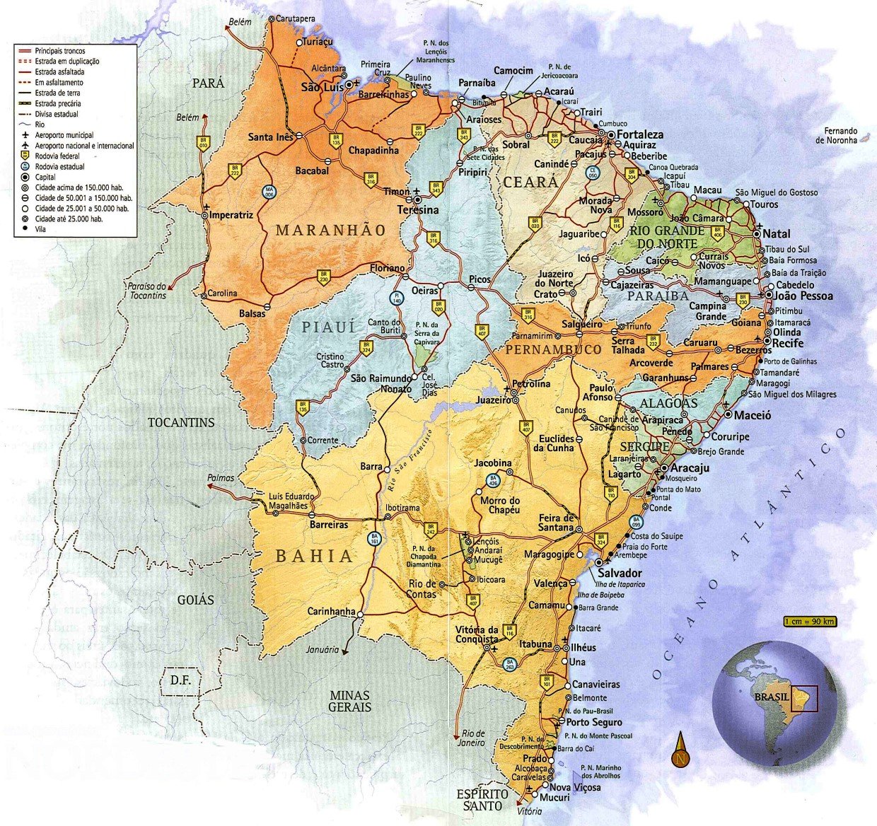
The Northeast is the third largest region in Brazil and the largest in number of states, with nine: Alagoas, Bahia, Ceará, Maranhão, Paraíba, Pernambuco, Piauí, Rio Grande do Norte and Sergipe.
Its total area is 1,561,177 km², similar to the area of Mongolia.
The region has 3,338 km of beaches, with Bahia having the longest coastline, at 938 km, and Piauí having the shortest, at 60 km.
Due to its different physical characteristics, the region has been divided by the IBGE into four sub-regions: Meio Norte, Caatinga, Agreste and Zona da Mata.
See the map of the Northeast region of Brazil
Videos about the 4 climate sub-regions of the Northeast

Região climática Zona da Mata02:43
Sub-região climática Agreste
Sub-região climática Sertão
Sub-região climática Meio-Norte02:54
Caatinga o coração do sertão nordestino24:41

Caracteristica da caatinga03:02

Caatinga parte 103:25

Caatinga parte 203:12

Caracteristicas dos estados nordestinos07:58
Climate regions and ecotourism in the Northeast

The climatic regions of the Northeast alternate in their landscapes and biomes:
- Forests
- mountains
- mountains
- cliffs
- inland
- Three thousand kilometres of coastline, with some of the country’s most beautiful beaches
Any school geography textbook will tell you that the northeast region of Brazil is made up of nine states: Bahia, Sergipe, Alagoas, Pernambuco, Paraíba and Rio Grande do Norte.
Moving west, along the western bend of the Brazilian coast, they are followed by Ceará, Piauí and Maranhão.
Together, these states cover some 1.5 million square kilometres – about 18% of the country’s territory.
This is no mean feat: the Northeast is larger than Portugal, Spain, France and Germany put together. That’s enough space to guarantee a diversity of terrain, climate, fauna, flora and – what the textbooks don’t tell you – plenty of alternatives for fun.
The geographical uniqueness of the North East is made up of contrasting landscapes. There are green forests and vast stretches of beaches and dunes; there are cliffs and lagoons with clear waters; there is the arid environment of the sertão and mountains with a mild climate.
It is a vast coastline with beaches of calm or rough waters, urbanised or wild.
The north-east has 4 climatic sub-regions
- Zona da Mata
- Agreste
- Sertão (Caatinga vegetation)
- Middle-North
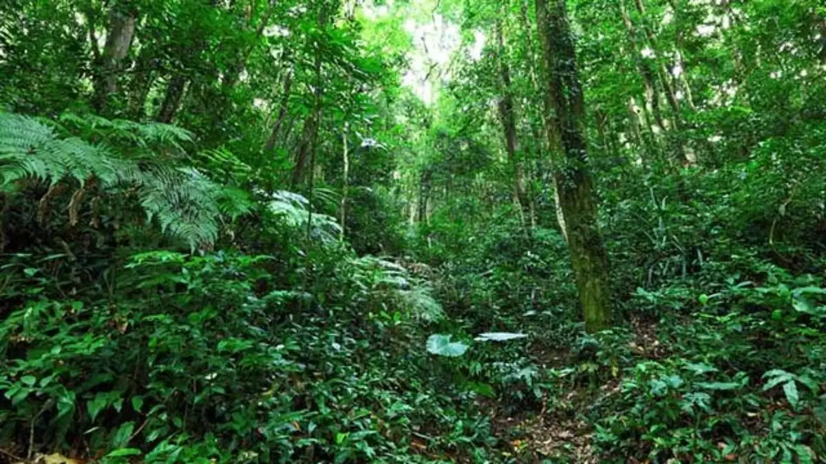
1. THE FOREST ZONE
This variety of landscapes is explained by the four climatic sub-regions that exist in the Northeast. One begins at the edge of the coast and stretches from Rio Grande do Norte to the south of Bahia.
, a strip of tropical climate, abundant rainfall and fertile soil, up to 200 kilometres wide in places.
It is still covered by Atlantic rainforest, although it has been violently deforested in a practice that dates back to colonial times: first for the exploitation of Brazilwood, then for the cultivation of sugar cane and cocoa, and later for the pulp industry and uncontrolled urbanisation.
The remaining patches of green are home to many endangered species, such as the micoleão, the muriqui monkey, the otter, the canastra armadillo and the jaguar.
This sub-region has the highest population concentration, is more urbanised and has better infrastructure, especially in terms of telecommunications and transport.
The Zona da Mata sub-region has the highest concentration of administrative institutions in the northeast, where the largest capitals are concentrated; the highest concentration of per capita income; commerce and services are the main activities. In addition to these aspects, the following can be mentioned:
– The climate is humid tropical and the soil is fertile due to the regularity of rainfall (intertropical region);
– The natural vegetation is the Atlantic rainforest, which is suffering great destruction;
– Agricultural activity is diversified, but in large estates consisting of monocultures such as sugar cane, cocoa, coffee, tobacco, etc. Although the region is not known for intensive agriculture, extensive production cannot be ruled out;
– Tourism is widespread in the region, with lush beaches and a warm climate for much of the year due to its proximity to the equator;
– Greater flows of people (especially tourism), goods, information, knowledge, finance and trade;
– Strong property speculation;
– Higher concentration of favelas;
– Higher concentration of educational institutions;
– Region with great opportunities for the application of sustainable energy such as wind power (due to coastal and trade winds);
– Largest concentration of urban problems such as air pollution, traffic, violence, heat islands, waste emissions, destruction of flora and fauna;
– Very accelerated occupation, linked to the historical process on the coast. It should be noted that Salvador was once the capital of Brazil.
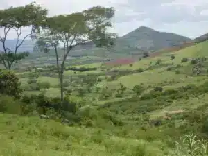
2. AGRESTE
Entering the area from the Zona da Mata, one reaches the Agreste.
A transitional area with no defined boundaries, this sub-region is characterised by land that is sometimes wet and full of marshes, and sometimes dry for long stretches.

In areas where it rains regularly, families grow crops to support themselves. In the drier areas, there is extensive livestock farming. The largest goat herd in the country is concentrated in the Agreste.
The Agreste is the part of the country that corresponds to the transition zone between the semi-arid Sertão (with predominantly caatinga vegetation) and the Zona da Mata (made up of Atlantic forest).
Some of its main characteristics are
– Rugged terrain, especially in the region known as the Borborema Plateau;
– Land tenure structure consisting of small and medium sized holdings engaged in polyculture (multiple crops) and extensive livestock rearing (particularly in search of land for expansion into the interior);
– Some areas may suffer from seasonal droughts and dry spells; the rainfall regime is irregular and rivers are temporary;
– Settlement is relatively slow compared to the Zona da Mata.
– The most prominent monocultures in this region are cotton and coffee;
– Large-scale food production;
– Sisal cultivation (extraction of fibres for the production of carpets, bags, ropes, etc.)
– Tourist attractions through events linked to local festivals.
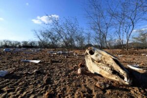
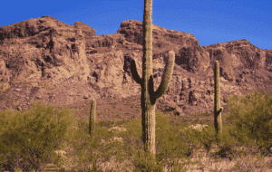
3. SERTÃO
The Sertão is the area with the greatest economic difficulties in the Northeast. Much of this sub-region lies within the so-called “drought polygon” in the centre of the Northeast region.

Some of the main characteristics are
– Low demographic index and high demographic dispersion (spatially dispersed population);
– Region with a transition zone between the Cerrado and the Caatinga, with a very low and irregular rainfall regime, characterised by intense (seasonal) droughts;
– Predominantly Caatinga vegetation.
– This region is dependent on water from the São Francisco River basin, considered the only perennial (constant) river in the region, whether for agriculture, human consumption, livestock or energy production.
– The largest population concentrations in the region are found close to the river, in this case in valleys such as the Cariri and São Francisco.
– Livestock farming is extensive, mainly beef (cattle suffer greatly from lack of water).
– Agricultural activity is concentrated near the water resources, which makes it possible to grow irrigated crops in the region, whether fruit, flowers, sugar cane, maize, beans, cotton, etc.
– Characteristic vegetation (caatinga), with shrubs (especially aroeira, angico and juazeiro); with bromeliads and cacti (especially mandacaru and xique-xique do Sertão).
The aridity of part of the Agreste foreshadows the caatinga vegetation, which stretches across eight states – only Sergipe is excluded.
It is the only exclusively Brazilian biome and is characterised by two seasons, the rainy season and the dry season.

What is caatinga?
The word caatinga means ‘white forest’ in Tupi and aptly describes the landscape of the Sertão during the dry season, when the leaves and trunks of trees and shrubs turn grey and disappear.
The dry caatinga soil cracks. The green colour returns with the rainy season.
The Caatinga hides a wealth of biodiversity
Beneath its apparent barrenness, the Caatinga hides a rich biodiversity. The flora includes cacti such as mandacaru, xiquexique and palm, shrubs and trees such as castor bean, hazelnut and piaçaba, and species of fine wood such as baraúna and cumaru; the juazeiro is a typical tree of the Sertão, the only evergreen species.
As for fauna, there are manuferos such as the mocó, the agouti, the preá, the gambá, the deer and the sagüi-do-nordeste, as well as lizards, snakes and birds – the suiá, picuí, carca rá and asa-branca.
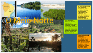
Halfway through the state of Piauí, the scenery changes. All the way to Maranhão you can see palm forests, the so-called coconut forests. This is the Mid-North, another transition zone, this time between the Sertão and the equatorial Amazon.
The local palm trees, which become more lush the closer you get to the Amazon, are a sign that the climate is getting wetter again.
Rich in buriti, oiticica, carnauba and babassu, they provide oil and wax for industry, especially cosmetics, and are home to an important bird fauna, with inhambus, saracuras, vultures, hawks, macaws, as well as marsupials, bats and bush rats, reptiles and predatory mammals.
4. MIDNORTH
Mid-North is a sub-region of Northeast that is related to the political-administrative region of North.

The Mid-North covers most of Maranhão and a large part of Piauí (west of the territory).
Some of its main characteristics are
– Transitional zone between the Amazon rainforest and the Cerrado. It is also a transition zone between the Cerrado and the Caatinga. As such, it is a transition zone between the Amazon and the semi-arid hinterland of the north-east;
– Its vegetation is characterised by coconut, carnauba and babassu forests.
– This region is home to the social movement of the coconut pickers (who are fighting against the large landowners who monopolise the land and production and exploit the labour force).
– Relatively high rainfall, especially in the west. This is due to the movement of the Atlantic Equatorial Mass (AEM);
– The region supports plant extraction, which keeps a large part of the workforce in the countryside. This takes place in coconut plantations, especially babassu, as well as cotton, sugar cane (decreasing, but still using “cold floats”) and rice (rice farming);
– Livestock farming is extensive (rudimentary);
– Destruction of vegetation due to intensive use of pastures;
– Wax can be extracted from the carnauba tree, which is used in many industries, including lubricants, plastics, adhesives and perfumes.
5. RIVERS AND SEA
The major rivers of the Northeast are the São Francisco and the Parnaíba.
The others play a less important role in the life of the population and are often intermittent, drying up during droughts.
5.1 The São Francisco River
The São Francisco River – affectionately called Velho Chico by the local population – rises in Minas Gerais and flows through Bahia, Pernambuco, Alagoas and Sergipe. It crosses the driest areas of the Northeast.
Discussions about the possibility of diverting some of its water to drier regions are old (the idea was first mooted in the Empire) and recurrent; since 2000 the project has been revived by the federal government, amid intense controversy.
The important hydroelectric potential of the Velho Chico is exploited mainly by the Sobradinho, Xingó and Paulo Afonso dams.
5.2 The Parnaíba River
The Parnaíba River flows through the states of Ceará, Piauí and Maranhão. Its mouth, on the border of the latter two states, forms the Parnaíba Delta – the largest open sea in the Americas – 70% of which is in Maranhão.
It is an important area of environmental conservation, where ecotourism has developed.
The Northeast is bordered by 3,500 kilometres of beaches, representing a third of the Brazilian coastline.
This long line crystallises the classic image of the region, the one that attracts most visitors and illustrates tourist brochures.
5.3 Dunes, cliffs, reefs, lagoons, natural pools, sandbanks and mangroves
The dunes, cliffs, reefs, lagoons, natural pools, sandbanks and mangroves all serve as habitats for various animal species – turtles, dugongs, whales and jellyfish.
They are home to many different species – from turtles to manatees and humpback whales, from crayfish to lobsters, as well as an abundance of fish that support entire communities.
The possibilities offered by this mosaic of landscapes and cultures are many – to travel the Northeast is to explore them, in a succession of surprises and discoveries.
North East Geography – The North East has four climatic sub-regions
Publicações Relacionadas
History of Northeast Brazil - Chronology and Summary
Cultural Aspects of Northeast Brazil Explained
História e Evolução do Trio Elétrico no Carnaval
Brazil’s Northeast: Must-See Tourist Destinations
The influence of Arab architecture on the buildings of Pernambuco
Northeastern architecture with typical colonial features
Jorge Amado's Life and Literary Contributions
Tropical flowers are grown on a large scale in northeastern Brazil
Rapadura: A Sweet Treat from Northeastern Brazil
Influences and main dishes of northeastern cuisine
Plastic Arts of the Northeast: A Cultural Journey
History of the introduction of Portuguese tiles in Brazil
Northeastern Literature: A Rich Cultural Tapestry
José Américo de Almeida: A Brazilian Literary Icon
Música, Ritmos e Danças do Nordeste do Brasil
Historic Towns in the Northeast: Explore the Past
Maranhão's handicrafts have more than 400 years of tradition
Tracunhaém and Its Rich Clay Handicraft Tradition
São Jorge dos Erasmos Sugar Mill: A Landmark in Brazil
History of Carnival in Brazil: Origins and Traditions
Casa Grande & Senzala: The Work of Gilberto Freyre
This post is also on:
![]() Português
Português ![]() English
English ![]() Deutsch
Deutsch ![]() Español
Español ![]() Français
Français


