Natural and Historical Attractions of The city of Camamu
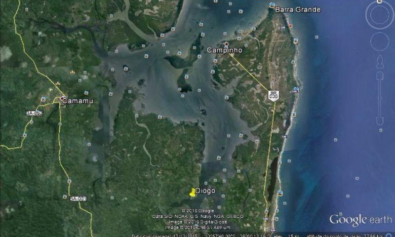
The city of Camamu is located on the banks of the Acaraí River, in the middle of a vast mangrove area.
The city preserves several architectural remains of its rich past.
It is the main port of embarkation for exploring the islands and beaches of Camamu Bay.

The third largest bay in Brazil by volume of water, after Baía de Todos os Santos and Baía de Guanabara, Camamu Bay is home to a variety of islands of different sizes, as well as beaches, forests and mangroves, all of which are still well preserved.

With constant winds, deep and calm waters, Camamu Bay offers ideal conditions for sailing, as well as many safe anchoring points.

Video about the city of Camamu and the islands of Camamu Bay
Baía de Camamu e Península de Maraú03:47

Cidade de Camamu na Bahia - Drone06:59

Pontos turísticos da Baía de Camamu BA10:15

Ilhas da Baía de Camamu - Parte 107:06

Ilhas da Baía de Camamu - Parte 203:27

Ilhas da Baía de Camamu - Parte 307:03

Ilha da Pedra Furada na Baía de Camamu04:56

Ilha do Goió03:14
History of the city of Camamu
Camamu is one of Brazil’s oldest cities and, like Salvador, was built on two levels.
In the upper town are the old churches and colonial houses; in the lower town are the port and shops. The region was originally inhabited by the Macamamus Indians.
The town’s origins date back to 1560, when the Jesuits built the Hermitage of Our Lady of the Assumption in Macamamu, giving the town its name.

During the colonial period, the village stood out as the largest producer of cassava flour in Brazil and became a target for pirates and invaders.
Between 1624 and 1627, the village suffered several attacks from the Dutch. To protect themselves from further invasions, the villagers blocked the passage to the harbour with huge rocks, which remain to this day, forcing boats to zigzag through the channel to reach the harbour.
In 1693 the village was elevated to town status and renamed Camamu.

In 1782, by order of the Portuguese Crown, the Bandeirante João Gonçalves da Costa opened the first road linking Camamu to the Bahian hinterland. Due to its importance for the economy of the province, it became known as the “Road of Nations”.
Camamu was promoted to city status in 1891.
In 1961, part of its territory was divided to form the municipality of Ibirapitanga.
Today the municipality has more than 32,000 inhabitants and covers an area of 885.20 km².

Tours around the islands of Camamu Bay
A dip in nature! Boat trips around Camamu Bay take visitors to unspoilt islands surrounded by native forest and small villages that keep the region’s traditional culture alive.

The ecosystem of Camamu Bay remains largely intact, with little pollution and little commercial exploitation. The local people live sustainably, relying on the sea for both food and transport, using handmade canoes carved from tree trunks.
The best way to explore the biodiversity of the bay is by speedboat, which allows you to navigate the maze of rivers, canals and islands, especially in the southern part of the region. The scenery offers a unique sense of tranquillity and awe-inspiring natural beauty.
Camamu Bay is home to one of the largest areas of preserved mangroves in Brazil. Unlike other coastal regions, where shrimp farming has devastated these ecosystems, Camamu Bay has remained protected because it is difficult to access. Fortunately, a large part of the area has been declared an Environmental Protection Area, guaranteeing its conservation.
Besides the islands, Camamu is also the embarkation port for the Barra Grande beaches and the Maraú peninsula, two of the most popular destinations on the Bahian coast.
1. Pedra Furada Island

Small but of great natural beauty, Pedra Furada Island enchants with its crystal clear waters and an imposing perforated rock that gives the place its name. It’s a great spot for photography and snorkelling.
2. Ilha Grande
The largest island in the bay, at about 4 km², it is also the most populated, with about 1,500 inhabitants. The island has beaches with calm, clean waters, a small harbour and several inns.
At the northern tip of the island, Prainha is a paradise. There are no cars and the roads are paths, ideal for walking.
3. Campinho Island

With calm, transparent waters, Campinho Island is perfect for snorkelling and is rich in marine life.
4. Sapinho Island
Sapinho Island is known for its preserved mangroves and its gastronomy. Bars and restaurants serve fried fish, crab, shrimp, lobster and moquecas, prepared with palm oil and chilli.
It’s a must for those taking a schooner trip around the bay. Separated by a small arm of the sea is the Island of Goió, famous for its private and paradisiacal beaches.
5. Goió Island

Goió Island impresses with its fine white sand and crystal clear sea. Its natural scenery is breathtaking and it is one of the most beautiful spots in the bay.
6. Other islands in Camamu Bay
In addition to the most visited islands, Ilha do Ámbar (formerly Quilombo), Ilha das Flores, Ilha do Contrato and Ilha da Coroa Vermelha complete the natural spectacle of Camamu Bay.
Tourist guide to the city of Camamu and the islands of Camamu Bay
Publicações Relacionadas
Maraú Peninsula: Explore Its Stunning Beaches
Taipu de Fora: Discovering Natural Pools
Camamu Bay — A Hidden Paradise in Bahia
Tinharé Archipelago: Discover Hidden Island Gems
Vila de Barra Grande na Bahia: Guia Completo para Turistas
Valença: The Gateway to Morro de São Paulo
Costa do Dendê: A Tropical Paradise in Bahia
Maraú Peninsula: A Coastal Paradise in Bahia
Morro de São Paulo: Experience the Unique Attractions
Garcez Beach: Discover Paradise in Jaguaripe
What to do on Boipeba Island - Tourist Guide - videos
Morro de São Paulo: Explore the Beaches and Nightlife
Cairu Archipelago: A Guide to Its Enchantment
This post is also on:
![]() Português
Português ![]() English
English ![]() Deutsch
Deutsch ![]() Español
Español ![]() Français
Français


