Discover the Tinharé Archipelago: A paradise of islands and beaches in Brazil
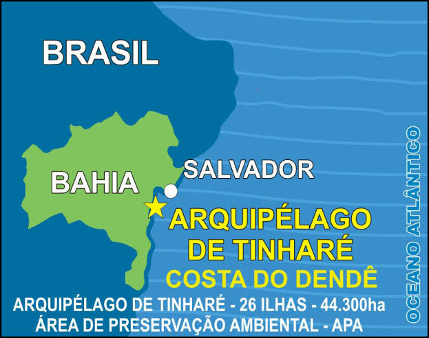
The Tinharé Archipelago, also known as the Cairu Archipelago, consists of 26 islands and is home to some of the most sought-after destinations for holidaymakers, such as the Beaches of Morro de São Paulo, Boipeba, Garapuá and Moreré.
Accessibility
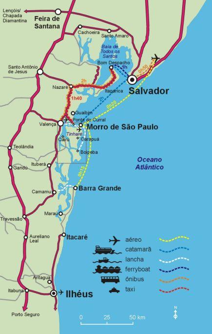
Ideal for those looking for sun and beach, these islands are only 173 kilometres from Salvador by road and 60 kilometres by boat.
The Tinharé Archipelago is also known as the Cairu Archipelago because it belongs to the Municipality of Cairu, which is the administrative centre of the region. Cairu was one of the first cities in colonial Brazil and is of great historical importance.
As the archipelago lies entirely within the boundaries of this municipality, it is also named after it. This reinforces the identity of the region and the connection between the islands and the city centre.

Special programmes
The islands have special programmes on public holidays and weekends, especially during the high season.
Preparing for the summer
As summer approaches, the archipelago, which belongs to the municipality of Cairu, is preparing to welcome tourists from Bahia, various parts of Brazil and abroad. The municipality has more than 400 square kilometres of natural beauty.
Popular destinations
The archipelago consists of 26 islands and is home to some of the most popular beaches in the southern lowlands: Morro de São Paulo, Boipeba, Garapuá and Moreré are destinations frequented by tourists and locals alike, whether for short or long stays.
Map of access to Morro de São Paulo
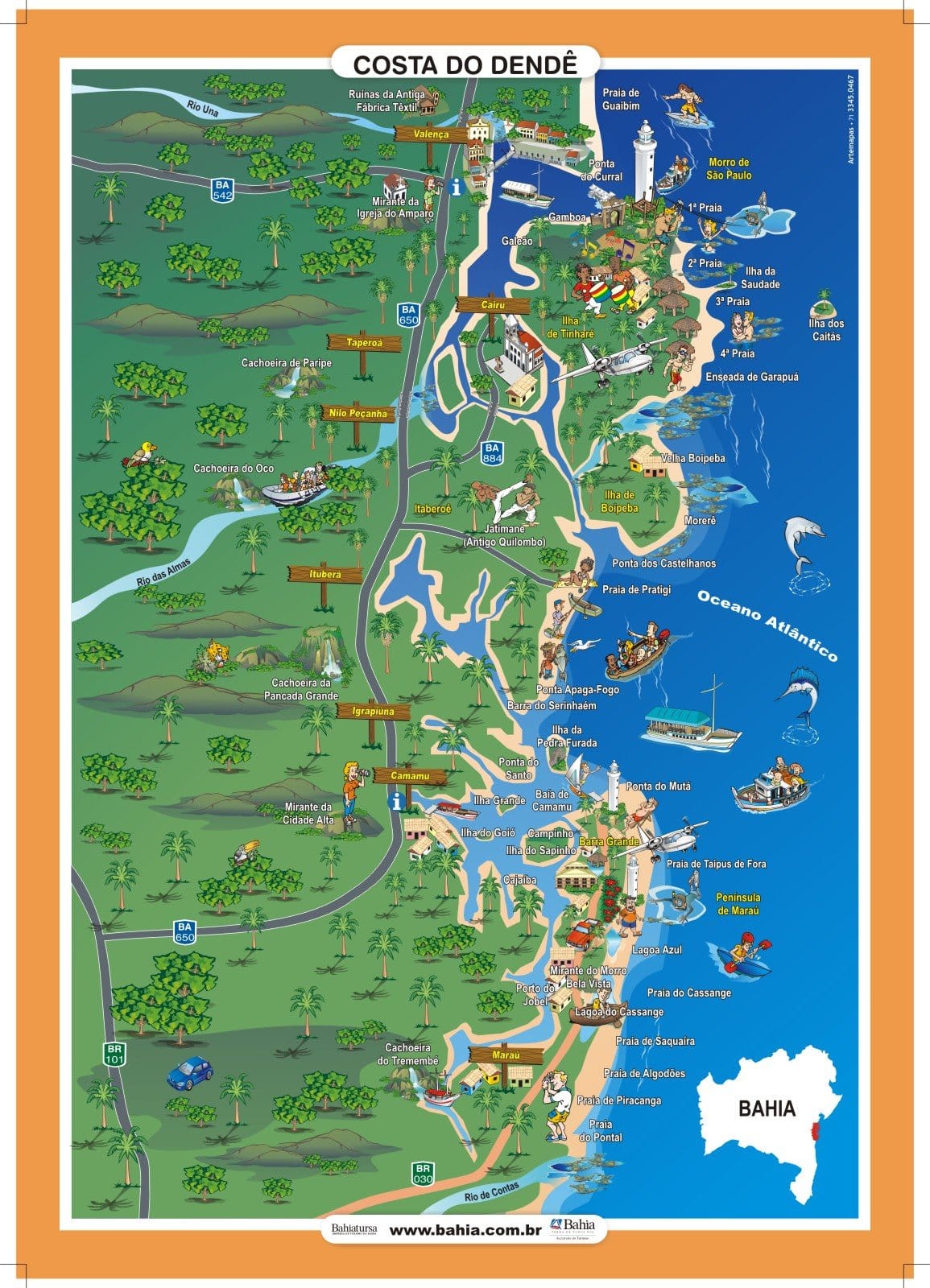
See the map of the Dendê Coast
Video of the Tinharé Archipelago in Bahia
Arquipélago de Tinharé - Morro de São Paulo, Boipeba, Gamboa e outras ilhas01:42
Arquipélago de Cairu - Pontos Turísticos02:15
See the complete guide to the Cairu Archipelago, also known as the Tinharé Archipelago!
Tinharé Archipelago in Bahia
1. Main tourist attractions
- Morro de São Paulo: Famous for its paradisiacal beaches, vibrant nightlife and breathtaking scenery.
- Cueira Beach (Boipeba): Known for its crystal clear waters and tranquillity.
- Moreré Natural Pools: Ideal for snorkelling and observing marine life.
- Garapuá Beach: A fishing village with beaches of calm waters and coconut trees.
- Morro de São Paulo Fortress: One of the most important historical monuments of the archipelago.
- Church and Convent of Santo Antônio de Cairu: Historical heritage dating from the 17th century.
- Morro de São Paulo Lighthouse: Offers spectacular panoramic views.
- Ponta dos Castelhanos: One of the best spots for snorkelling and boat trips.

")


The Tinharé Archipelago is also one of the few archipelago municipalities in Brazil, with Cairu as its administrative centre.
2. Geography and access
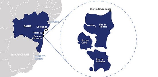
Morro de São Paulo is located at the northern end of the island of Tinharé, which together with Boipeba, Cairu and 23 other small islands make up the archipelago.
It is located about 60 kilometres south of Salvador, near the city of Valença.
The islands are separated from each other and the mainland by large mangrove channels, making access difficult. Many places remain uninhabited and are rarely visited as navigation depends on the tides and access by land is almost impractical.
The east coast of the archipelago, where the beaches are, is the most accessible region. The waters are deeper, but most of the beaches are protected by reefs that only allow access at certain points.
The channel to the north of Tinharé Island is also deep, although it has sandbanks. Through this channel you can reach Ponta do Curral and the city of Valença, both on the mainland.
The other channels are shallow and treacherous and can only be navigated by those who know the area well and at the right tide.
The archipelago covers about 451 square kilometres, with Tinharé being the largest island, occupying 54% of the total area. Boipeba and Cairu have a similar area, about 20 per cent each, while the other 23 islands account for less than 7 per cent of the total.
The highest elevations are in the north of the island of Tinharé, where there is a lighthouse, and in the north-west, at the town of Galeão. The rest of the island is practically flat, only a few metres above sea level. The islands of Boipeba and Cairu, on the other hand, have more undulating terrain, but their elevations do not exceed 80 metres.
There are almost no roads, only paths travelled on foot, on horseback or, in some cases, by tractor. Goods are mostly transported by wooden boats called sloops.
The villages are located along the sea and navigable canals. On the island of Tinharé, the following stand out: Morro de São Paulo, Gamboa, Galeão, Zimbo, Garapuá and Canavieira.
On the island of Boipeba, the main villages are Velha Boipeba, Moreré, Monte Alegre and São Sebastião (Cova da Onça). In Cairu, in addition to the town centre, there is the village of Torrinhas.
The archipelago has a total population of 11,410, fairly evenly distributed between the three main inhabited islands. The local economy depends mainly on activities linked to the sea, such as fishing and, more recently, tourism.
The population is a mixture of blacks and Europeans, mainly Portuguese, Dutch and indigenous. The people are known for being quiet, modest and welcoming to visitors.
3. Ecosystem and conservation
Most of the islands were originally covered by Atlantic rainforest, but today coconut groves predominate. There are still large areas of virgin forest and extensive restinga regions. However, the most important ecosystem in the archipelago is the mangrove swamp, which acts as a nursery for marine life and provides support for the population.
Since 1992, the islands of Tinharé and Boipeba have been part of an Environmental Protection Area (APA). However, challenges remain, such as waste management, although significant progress has been made, such as improvements in wastewater treatment.
Several NGOs are active in the archipelago, trying to implement sustainable economic alternatives for the local population. The future of the region depends on cooperation between residents, business people, authorities and tourists to ensure a balance between development and environmental conservation.
Tourist guide to the Tinharé Archipelago in Bahia
Publicações Relacionadas
Maraú Peninsula: A Coastal Paradise in Bahia
Costa do Dendê: A Tropical Paradise in Bahia
Morro de São Paulo: Experience the Unique Attractions
Camamu Bay — A Hidden Paradise in Bahia
Vila de Barra Grande na Bahia: Guia Completo para Turistas
Cairu Archipelago: A Guide to Its Enchantment
Taipu de Fora: Discovering Natural Pools
What to do on Boipeba Island - Tourist Guide - videos
Morro de São Paulo: Explore the Beaches and Nightlife
Maraú Peninsula: Explore Its Stunning Beaches
City of Camamu: Rich History by the Bay
Valença: The Gateway to Morro de São Paulo
Garcez Beach: Discover Paradise in Jaguaripe
This post is also on:
![]() Português
Português ![]() English
English ![]() Deutsch
Deutsch ![]() Español
Español ![]() Français
Français


