Discover Morro de São Paulo: A hidden paradise on the Dendê Coast
Morro de São Paulo, located on the Dendê Coast, is one of the most beautiful and popular destinations on the Bahian coast.
It belongs to the municipality of Cairu, in the Southern Bahia Lowlands, and is located in the Tinharé Archipelago.
Because it is an island, there is no circulation of tourist cars; only 4×4 vehicles, agency motorcycles, quads and wheelbarrows are allowed.

Tourist transformation
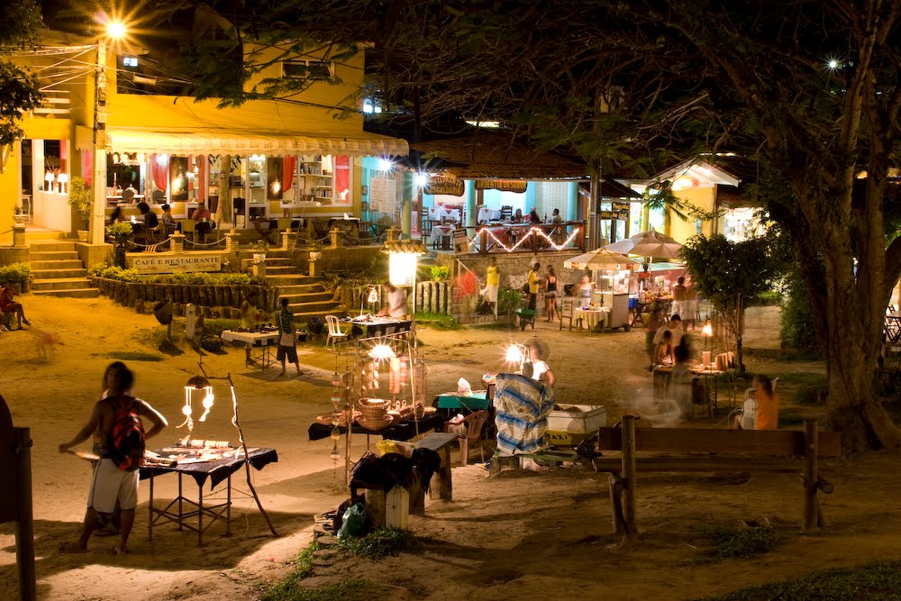
The quiet village of two decades ago has been transformed by the growth of tourism, giving way to a bustling Morro de São Paulo, full of pubs, restaurants, shops and a vibrant nightlife.
The famous Caminho da Praia Street concentrates most of these attractions.
Charm and tradition
In Aureliano Lima Square, in the centre of the village, the cobblestones give the place its charm. At the Second Beach, a wooden footbridge provides easy access to the Third Beach.
Despite the modernisation, one feature remains intact: the natural beauty and quiet – especially from the Third Beach towards the south of Tinharé Island.

Main Points of Interest
The main attractions in Morro de São Paulo are Rua Caminho da Praia and Segunda Praia.
The Fifth Beach, also called Praia do Encanto, is closest to the village and is actually a southern extension of the Fourth Beach.
Boipeba Island
The Island of Boipeba is home to four true jewels of the Brazilian coast: Cueira, Moreré, Bainema and Ponta de Castelhanos.
Known for its unspoilt beaches and rich ecosystems, Boipeba is an essential destination for nature and ecotourism lovers.
Unique experience
Despite the short distance of 50 minutes, when you arrive you will feel as if you are in another world due to the tranquillity and serenity of the place.
This unique experience makes Boipeba the perfect refuge for those seeking contact with nature and an escape from the hustle and bustle.
The island also offers a wide range of activities, such as water sports, boat trips and hiking, to make your visit even more enjoyable.

See the map of the Dendê Coast
Videos about Morro de São Paulo

Morro de São Paulo na Bahia04:39

Morro de São Paulo - Dicas06:59

Morro de São Paulo e Tinharé09:41
Morro de São Paulo a noite02:37
Morro de São Paulo - Reportagem Completa33:46
Noite em Morro de São Paulo o que fazer?12:31
O que não te contaram sobre Morro de São Paulo08:08
Morro de São Paulo in Bahia

Main beaches
The main beaches are located in the south of the island and are numbered:
- First beach
- Second beach
- Third beach
- Fourth beach
- Fifth Beach (Praia do Encanto)
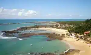
With warm, crystal clear waters, these beaches offer a real swim in the sea and a unique connection with nature.
While Second Beach is the most popular, Fourth Beach and Fifth Beach are virtually deserted, true oases of tranquillity.
To the north of the village, there are also beaches less explored by tourists:
- Porto de Cima beach
- Ponta da Pedra beach
- Gamboa beach
1. First beach
The closest to the village and the first to receive holiday homes. Very frequented by locals, it offers some stands with typical Bahian cuisine.

A highlight is the longest zip line in Brazil, where tourists descend to enjoy the breathtaking views.
2. Second beach
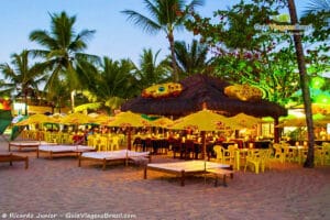
The busiest and most popular on the island, with a large concentration of bars and restaurants.

At night, there are craft stalls, typical drinks such as caipirutas and the famous luau, with live music and lots of axé.
3. Third beach
This is the starting point for boat trips to explore the area. It has a large number of guesthouses and restaurants to suit all budgets.

The strip of sand narrows at high tide, but the infrastructure makes up for it.
4. Fourth Beach
Known for its calm, crystal clear waters, full of coconut palms and over four kilometres of pure peace and beauty.

Perfect for long walks by the sea.
5. Fifth Beach (Praia do Encanto)
Located six kilometres from the village, this is the most unspoilt beach on the island.
It has fine white sand, warm waters and mangroves, as well as a barrier reef that forms incredible natural pools for snorkelling.
6. Gamboa beach
Located in the north of the island, on the way to Porto de Cima Beach and Ponta da Pedra Beach.

Gamboa do Morro is a fishing village that is still little visited by tourists.
It has huts by the sea where typical Bahian cuisine is served, prepared by the fishermen’s families, known for their hospitality and authentic gastronomy.

How to get around
Only tractors, gardeners and vehicles belonging to inns and tourist agencies are allowed.
From the pier you can walk to the Third Beach and from the Fourth Beach you can hire a horse-drawn carriage.
On arrival, porters can carry your luggage in wheelbarrows.
When to go
The climate is stable all year round, ideal for the beach at any time of year. For more excitement, choose summer (December to February), when there are frequent parties and the sea is perfect for swimming.
How to get there

1. Semi-terrestrial route
Take the ferry from Salvador to Bom Despacho(Itaparica Island).
From there take a car, bus or transfer to Valença.
Park in Valença and take a boat or speedboat to Morro de São Paulo.
The crossing from Valença takes about 30 minutes.
2. Overland route to Valença
Take the BR-101 from Salvador to Santo Antônio de Jesus.
Continue on the BA-046 to Nazaré das Farinhas and on the BA-001 to Valença.
Distance by road: approximately 3h30 (270 km).
3. By Catamaran
Direct option from Salvador Maritime Terminal to Morro.
Duration: about 2 hours.
May cause seasickness due to the instability of the sea.
4. Air Taxi
Direct air transfer to Morro de São Paulo.
Landing at the Regional Airport of Cairu, on the Island of Tinharé.
Faster and more exclusive option, but also more expensive.
History of Morro de São Paulo
Morro de São Paulo is not only known for its natural beauty and rich culture.
The island is also steeped in history. It was discovered in 1531 by the Portuguese navigator Martim Afonso de Sousa.
It had a great influence on the colonial period and was the target of piracy and smuggling throughout its history.
It even witnessed the Second World War when the Nazis torpedoed and sank the ships Arará and Itagiba off the First Beach of Morro de São Paulo.
This led Brazil into the Second World War.
Before the Portuguese arrived in Morro de São Paulo, these lands were inhabited by the Aimorés and Gueréns Indians.
It wasn’t until 1534 that the then King of Portugal, João III, divided the coast of Bahia into three captaincies, one of which was the Captaincy of Ilhéus, which included the archipelago of Tinharé, where Morro de São Paulo is located.
So on Saint Paul’s Day (29 July), Lieutenant Francisco Romero chose Morro de São Paulo as the seat of the captaincy.
The seat didn’t last long and was moved. However, colonisation continued and never stopped, and its function as a strategic location also remained.
In 1630, construction began on the Tapirandú Fortress to defend the capital from Dutch attacks and theft of goods. The construction of the Church of Nossa Senhora da Luz – named after its patron saint – began in 1628 and was not completed until 1845.
The houses and the population grew, and in 1746 work began on the Fonte Grande to provide water for the population and the troops.
Former residents say that until recently they used to bathe together because of the lack of mains water.
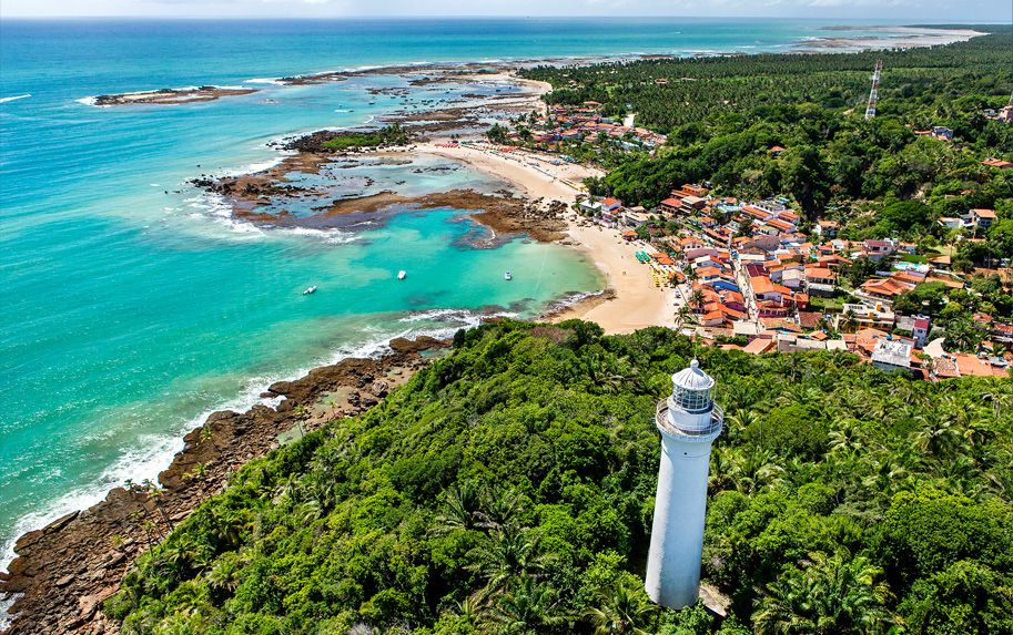
In 1848, construction began on the Morro de São Paulo lighthouse to facilitate access to the city of Valença.

Morro de São Paulo is today one of the most popular tropical destinations for tourists from all over the world. From the 1970s, the city underwent a transformation, driven by the arrival of the first holidaymakers, backpackers and hippies, who spread the fame of the place.
Chronology
The Morro de São Paulo protected the so-called False Bar of All Saints’ Bay, the strategic entrance to the Itaparica Canal as far as the Santo Antônio Fort (now the Barra Lighthouse); and the Tinharé Canal was essential for transporting produce from the main centres to supply the capital, Salvador.
The island’s geographical importance during the colonial period justifies its wealth of historical monuments, now protected by the National Historical Heritage.
1531
Martim Afonso de Sousa lands on the island of Tinharé, which becomes part of the Captaincy of São Jorge dos Ilhéus. King João III donates the land to Jorge de Figueiredo Correa, who begins the process of colonisation.
1535
Francisco Romero and the local population found the village of Morro de São Paulo at the northern end of the island.
1624
Commander Johan Van Dortt and his squadron land on the island en route to Salvador.
1628
Dutch admiral Pieter Pieterzoon Hiyn leads the attack and plundering of the village.
1630
Governor General Diogo Luiz de Oliveira begins construction of the Morro de São Paulo fortress.
1728
Completion of the construction of the Ponta Fort and the ramparts along the island. Defeat of the French admiral Villegaignon by Lusitanian troops.
1746
Construction of Fonte Grande, the largest water supply system in colonial Bahia.
1845
Work is completed on St Anthony’s Church and Convent, the Chapel of Our Lady of Light.
1855
Eng Carson completes construction of the lighthouse.
1859
Visit of the Royal Family and D. Pedro II.
Tourist guide to Morro de São Paulo in Bahia
Publicações Relacionadas
Maraú Peninsula: A Coastal Paradise in Bahia
Taipu de Fora: Discovering Natural Pools
Maraú Peninsula: Explore Its Stunning Beaches
What to do on Boipeba Island - Tourist Guide - videos
Camamu Bay — A Hidden Paradise in Bahia
Garcez Beach: Discover Paradise in Jaguaripe
Costa do Dendê: A Tropical Paradise in Bahia
Valença: The Gateway to Morro de São Paulo
Vila de Barra Grande na Bahia: Guia Completo para Turistas
Cairu Archipelago: A Guide to Its Enchantment
Morro de São Paulo: Explore the Beaches and Nightlife
City of Camamu: Rich History by the Bay
Tinharé Archipelago: Discover Hidden Island Gems
This post is also on:
![]() Português
Português ![]() English
English ![]() Deutsch
Deutsch ![]() Español
Español ![]() Français
Français


