Tourist Attractions, Architecture and History of Icó in Ceará
Icó is a Brazilian municipality in the state of Ceará and a living testament to the colonial architecture of the north-eastern sertão. The town was the third settlement to be established in Ceará, after Aquiraz and Fortaleza, and boasts an architectural ensemble dating from the 18th century.

Between the 18th and 19th centuries, Icó was the most important cattle trading centre in Ceará.
Situated in the Cariri region, its colonisation by the Portuguese met with fierce resistance from the Cariri Indians, the traditional rulers of the region.
Granted town status in 1738, a significant part of Icó’s town centre is now listed by the Federal Historical Heritage Institute (IPHAN). Among the highlights are the Teatro da Ribeira and the Town Hall and Prison, both built in 1860, as well as the Church of Nossa Senhora da Conceição do Monte, which has been restored and listed by the National Historical Heritage Institute.
Magnificent townhouses adorned with Portuguese tiles dominate the cityscape — a reflection of a town that grew out of the urban layout planned by the Portuguese Crown in the first half of the 18th century, with well-defined, straight streets delineating relatively uniform blocks, spacious squares and public buildings. The historic centre is situated between the present-day Rua 7 de Setembro, Rua Ilídio Sampaio and Rua Benjamin Constant, bordered on the east by the main square.
Tourist Attractions in Icó

Icó - Pontos Turisticos00:30

Icó - Vídeo da Cidade01:54

Icó - Guia de Turismo e História19:56

Arquitetura e História de Icó no Ceará07:58
Icós Riverside Theatre
Dating from 1860, it is the work of the architect Henrique Théberge, son of the doctor and historian Pedro Théberge, who financed this Neoclassical building.

It is the oldest theatre in the state of Ceará. It comprises two storeys: on the ground floor there are three galleries; on the first floor, there are upper boxes.
Town Hall and Prison
Dating from the second half of the 18th century, it was one of the most secure prisons of its time. Its gates are veritable fortresses.

The cells feature one of the most sophisticated security systems of their time, with walls one and a half metres thick; the keys are unique and weigh approximately half a kilo each.
Inside is the prison chapel, which houses an image of Saint Dominic, the patron saint of prisoners.
The building comprises two storeys: the Town Hall was housed on the upper floor, whilst the ground floor housed the Public Prison. It is currently out of use and is undergoing restoration work.
Church of Our Lady of Expectation

This Baroque-style church, situated in Largo do Théberge, is the town’s parish church. Next to the church on the hill, just before the turn-off for Orós, lies the century-old cemetery.
The History of Icó in Ceará
The word Icó is of indigenous origin and means ‘water or river of the countryside’. It is also the name of a Tapuia tribe belonging to the Cariri-Icós Nation, settled on the banks of the Salgado River (CE) and the Rio do Peixe (PB), and of a tree of the Caparidaceae family, known as the icozeiro.
Before it came to be known by this name, the area had many other names: Ribeira dos Icós, Arraial Velho, Arraial Novo, Arraial de Nossa Senhora do Ó, Sítio de Nossa Senhora do Ó dos Icós, Povoação do Salgado, Icó dos Fonsecas, Icó dos Montes and, finally, Icó.

Despite resistance from the local population and the controversies surrounding the origin of the name over the years, Icó is also known as the ‘land of the laurel’.
In the early 18th century, the indigenous tribes inhabiting the region put up fierce resistance to the colonisers. Between the Pereiro mountain ranges and the vast hinterlands of Cedro, Captain-General Gabriel da Silva Lago ordered the construction of a palisade to defend and protect the settlers along the banks of the River Salgado against attacks by the indigenous peoples.
It was there that a settlement sprang up — the present-day Icó. Following bloody conflicts between land-grabbing settlers, colonisers and indigenous peoples, Father João de Matos Serra, Vicar General of the Missions, brought about peace. With the end of the conflicts, the settlement of Ribeira dos Icós flourished and developed around the Chapel of Nossa Senhora da Expectação, the land for which was donated by Francisco Montes Silva in 1709.
The settlement and development of the region were led by the Monte and Feitosa families, who enjoyed great prestige and controlled vast swathes of the territory. The settlement grew into the town of Icó, situated at a strategic junction of two important colonial trade routes: the Estrada Geral do Jaguaribe, which linked Ceará to Pernambuco (Porto de Aracati–Icó–Cariri), and the Estrada das Boiadas or dos Inhamuns, which linked Ceará to Piauí and Paraíba. The ‘Estrada Nova das Boiadas’ also converged on Icó; this route set off from Sobral and crossed the central hinterland of Ceará.
In the mid-18th century, the Chapel of Nossa Senhora do Ó, patron saint of the village, was built by Francisco Monte — a period during which the village experienced significant economic development, driven by cattle farming across the North-East. The complex of two-storey houses built in the historic centre is a testament to this prosperity.
From village to town: the correct dates
By royal decree of 20 October 1736, the settlement of Ribeira dos Icós was elevated to the status of a town. The official establishment, however, did not take place until 1738 — a date now regarded by the municipality as that of its foundation. Icó thus became the third town in Ceará, after Aquiraz and Fortaleza. Its elevation from a town to a city, however, did not occur until 1842, by which time Icó was already ranked amongst the province’s most important commercial and cultural centres.
1824 — Icó and the Confederation of Ecuador
The Confederation of Ecuador was a revolutionary movement of 1824, led in Ceará by Tristão Gonçalves de Alencar Araripe, which played a prominent role in Icó. Dissatisfied with the abuses of power by Emperor Dom Pedro I, the provinces of Pernambuco, Paraíba, Rio Grande do Norte and Ceará joined together to form a confederation, but were harshly suppressed.
The movement, which was separatist and republican in nature, began in Pernambuco and found widespread support amongst the people of Ceará. Its main leader, Joaquim do Amor Divino Rabelo — known as Frei Caneca — was shot in Recife. In Icó, the participants were also severely punished: a provisional municipal government was established and a commission appointed by the Imperial Government was tasked with punishing those involved.
The Architectural and Urban Complex of Icó
The Architectural and Urban Complex of Icó brings together the city’s most significant heritage sites and the urban layout imposed by the Portuguese Crown in the 18th century. Listed by IPHAN in 1998, it is regarded as one of the finest examples of traditional architecture in Ceará, including in the vernacular style — and Icó was the first town in Ceará to be granted this type of listing for an urban ensemble.

This heritage is concentrated along the city’s main streets, where the most significant buildings are located and where the urban layout was dictated by the regulations of the Portuguese Crown in the 18th century. The area designated for protection comprises approximately 320 properties.

Comprising mainly Portuguese and French influences, the architecture of Icó has inherited elements of the Baroque style, combined with features characteristic of the North-East, as well as aspects of French Neoclassicism. During the gold rush and the production of beef jerky in the 18th and 19th centuries, Icó flourished as an important trading post in the interior of the province of Ceará — a period which left behind countless buildings, true testaments to the settlement of the north-eastern hinterland by the cattle industry. Even in the oldest churches, there are no complex woodcarvings or stone carvings: like all traditional architecture in Ceará, that of Icó is characterised by simplicity and austerity.

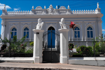
The only building in the town with a more refined architectural style is the Ribeira dos Icós Theatre, with its neoclassical features. Some townhouses on Rua Ilídio Sampaio, in the oldest part of the town, feature façades with more elaborate decorative elements, such as balustrades, mouldings and Portuguese tile cladding. Also worthy of note is the architectural work on buildings constructed or refurbished between the late 19th and early 20th centuries.

It is worth noting this architecture’s ability to adapt the basic repertoire of Brazilian colonial architecture to the rugged environment and scarcity of the sertão. Situated at the crossroads of cattle trails, Icó became the most important trading post in the interior of the province of Ceará — the construction of churches, the prison, the market and the townhouses with Portuguese tiles dates from this period.
The town’s development began to decline with the fall in exports of livestock products, as a result of successive droughts and competition from cattle reared on the pastures of southern and south-eastern Brazil.

Paradoxically, the city’s political and economic decline contributed to the preservation of much of its architectural and urban heritage. The new area of urban expansion emerged to the east of the River Salgado, sparing the historic centre from major changes.
One of the most striking features of Icó’s colonial urban planning is the fact that the town is situated with its ‘back’ to the River Salgado, a tributary of the River Jaguaribe. Its valuable architectural heritage remains largely intact, serving as a living testament to the settlement of the north-eastern sertão.
How to get to Icó
Icó is situated about 365 km from Fortaleza, in the south-central region of Ceará, on the banks of the River Salgado. The most common route is via the BR-116 and state roads linking the town to the Cariri region and the Jaguaribe Valley; the journey usually takes between 4 hours 30 minutes and 5 hours by car.
Frequently Asked Questions about Icó
Was Icó really the third town in Ceará?
Yes. After Aquiraz and Fortaleza, Icó was the third settlement to be elevated to the status of a town in the state, by royal decree of 1736, with the official establishment taking place in 1738.
When did Icó become a town?
The village was granted town status in 1842, by which time it had already established itself as one of the most important commercial and cultural centres in the interior of Ceará.
What has been listed by IPHAN in Icó?
The Architectural and Urban Complex of Icó, listed in 1998, comprises around 320 buildings in the town’s historic centre, as well as individual monuments such as the Ribeira Theatre and the Church of Nossa Senhora da Expectação.
What are the main tourist attractions in Icó?
The Ribeira dos Icós Theatre (the oldest in Ceará), the Town Hall and Prison, the Church of Nossa Senhora da Expectação and the cluster of colonial townhouses with Portuguese tiles in the historic centre.
Where does the name ‘Icó’ come from?
‘Icó’ has Tapuia indigenous origins and means ‘water or river of the farm’. It is also the name of a tribe that lived on the banks of the River Salgado and of a tree native to the caatinga, the icozeiro.
See also
- Cariri in Ceará: A Destination for Ecotourism and Cultural Tourism
- Salgado River Canyon in Lavras da Mangabeira, Ceará
- Tourism in the Cariri region of Ceará: A complete 3-day itinerary through the Araripe Geopark
- Juazeiro do Norte and its Religious Roots
- Fortim: Attractions at Pontal de Maceió Beach and the Jaguaribe River
- Ceará: Must-See Tourist Destinations in Brazil
Tourist Guide to Icó in Ceará and the North-East

Publicações Relacionadas
Tourism in the Cariri region of Ceará: A complete 3-day itinerary through the Araripe Geopark
Quixadá, Ceará: Monoliths, the Cedro Dam and the Sertão
Kitesurfing in Tatajuba — Spots, Access and Season
Cariri in Ceará: A Comprehensive Guide to Tourism and Culture
The Costa dos Ventos Route, Ceará: A Complete Guide to 9 Towns
Ceará: Brazil’s Must-See Tourist Destinations
The Baturité Massif: A Complete Guide to Tourism in Ceará
The Cliffs Route in Ceará: A Complete Travel Guide
Tatajuba, Ceará: things to do, how to get there and top attractions
Ceará: The Best of Ecotourism and Extreme Sports in Brazil
Religious Tourism in Cariri (CE): Padre Cícero and Pilgrimages
What to Do in Fortaleza in 3 Days: A Complete Itinerary
Where to Stay in Fortaleza: Neighbourhoods and Beaches (2026)
Salgado River Canyon in Lavras da Mangabeira, Ceará
Fortaleza: A Guide to Ceará's Vibrant Capital
Canoa Quebrada, Ceará: A Guide to Cliffs and Beaches
Ubajara National Park: A Complete Visitor’s Guide
Things to Do in Paracuru, Ceará: Beaches and Sports
Beaches on the West Coast of Ceará: A Complete Guide
Aracati, CE: A Complete Guide to Canoa Quebrada and the Surrounding Area
The East Coast of Ceará: A Complete Guide to Beaches and Cliffs
Aquiraz, Ceará: Guide to Porto das Dunas and Beach Park
Route of Emotions: An Adventure through North-East Brazil
Caetanos de Cima is one of the most beautiful beaches in Ceará
The Best Beaches in Fortaleza and Ceará: A Complete Guide with 22 Options
Cumbuco Beach (Ceará): The Definitive Guide to Kitesurfing and Leisure
Juazeiro do Norte: Things to Do and a Guide to Religious Tourism
The Mountains of Ceará: A Guide to Mountain Towns for Tourists
Guaramiranga: The Complete Guide to the ‘Switzerland of Ceará’ (Itineraries and Tips)
Icapuí, Ceará: The perfect destination for those seeking the ‘Land of the Lobster’
Jericoacoara, Ceará: Complete Guide and 5-Day Itinerary
Serra da Ibiapaba: A Complete Guide to Attractions and Tips
Fortim and the Jaguaribe River, Ceará: A Complete Travel Guide
Beach Park – Complete guide: attractions, tickets and tips for Porto das Duna
This post is also on:
 Português
 English
 Deutsch
 Español
 Français