Discover the beauty of Lençóis Maranhenses National Park
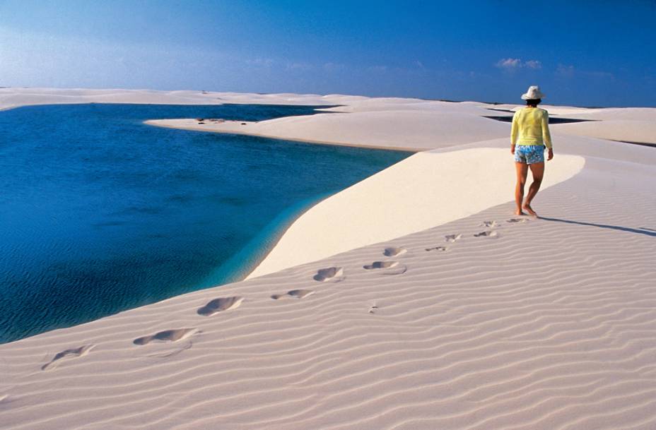
The dunes of the Lençóis Maranhenses National Park look like gigantic sheets of sand.
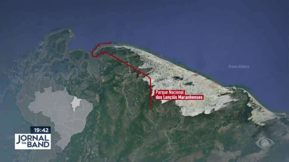
Location
The Lençóis Maranhenses National Park includes the municipalities of Paulino Neves, Tutóia, Barreirinhas, Santo Amaro, Primeira Cruz and Humberto de Campos.
Territory and ecosystem
Lençóis maranhenses têm beleza inigualável

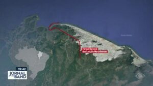
Parque Nacional dos Lençóis Maranhenses

Lençóis Maranhenses - Drone

Barreirinhas - Lençóis Maranhenses02:55

Lençóis Maranhenses Guia38:46

Lençóis Maranhenses Reportagem02:47

Rota das Emoções Nordeste06:00

Tutóia - Lençóis Maranhenses05:12
Lençóis Maranhenses - Reportagem Completa13:09
Barreirinhas - Lençóis Maranhenses05:14
Caburé é um vilarejo de pescadores no Maranhão13:04
Passeio pelo Rio Preguiças
Santo Amaro do Maranhão10:00
The Lençóis Maranhenses National Park covers 155,000 hectares of dunes, rivers, lagoons and mangroves.
There are two types of scenery, depending on the time of year: during the drought, the park becomes a veritable desert, bathed by the ocean; during the rains, the classic landscape of the place is formed, an incredible sequence of dunes and lagoons.

A unique experience
Exploring this vast expanse of sand is a unique and gruelling experience. In the 1970s, a Petrobras team flew over Morrarias and named it Lençóis Maranhenses.
It’s impressive; anyone who sees the sand, the dunes, has the feeling of looking at gigantic sheets, swaying in the wind under the sun.
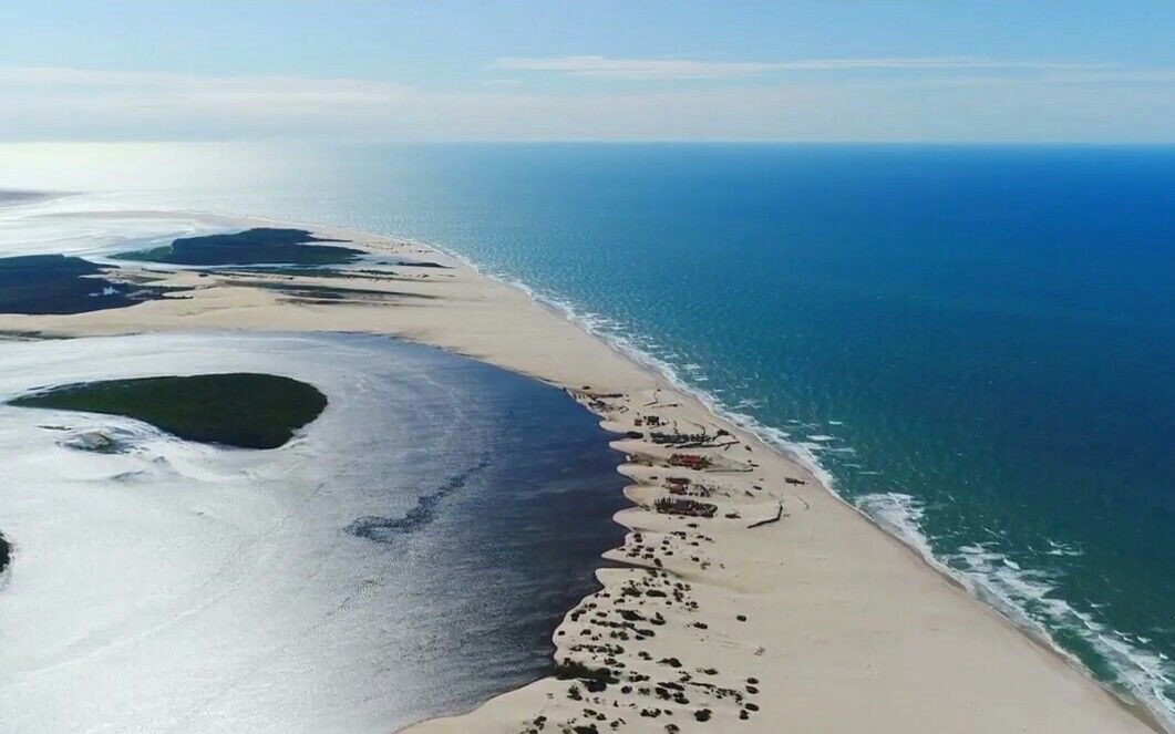
It is the wind that creates the nearly 50 metre high dunes that stretch for 100 kilometres along the coast and 50 kilometres inland.
On the coast, the beaches are wide and long. Inland, “marraria”, or dunes, predominate, interspersed with lagoons formed by rainwater.
Distribution of the dunes
The dunes are spread over two deserts: the Large Lençóis Maranhenses, to the west of the Preguiças River, and the Little Lençóis, to the east.
Inaugurated in 1981, the Lençóis Maranhenses National Park covers an area of 155,000 hectares, with a 270 km perimeter, where the municipalities of Paulino Neves, Tutóia, Barreirinhas, Santo Amaro, Primeira Cruz and Humberto de Campos are located.

Tourist Attractions of Lençóis Maranhenses National Park
- Barreirinhas
- Santo Amaro do Maranhão
- Little Lençois
- Caburé
- Preguiças River Cruise
- Lagoons
- Flight over the park
- Atins
- Queimada dos Britos
1. Barreirinhas
Barreirinhas - Lençóis Maranhenses
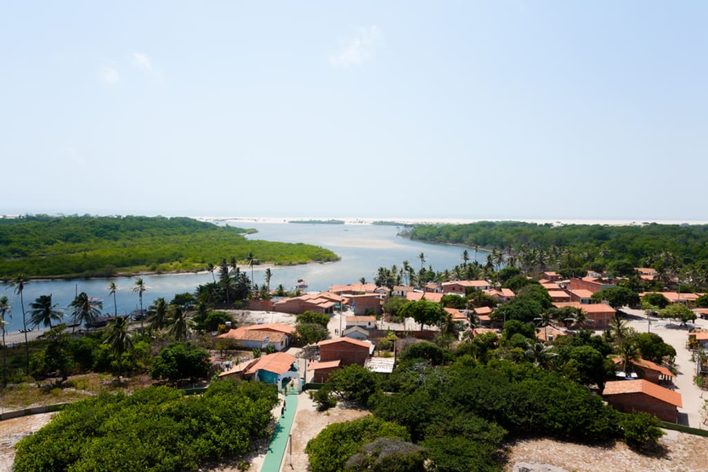
Barreirinhas is the most structured city in the Lençóis Maranhenses Natural Park, located 260 kilometres from São Luís.
It is the headquarters of the Park and the main starting point for trips along the Preguiças River, as well as being on the tourist route that includes the Parnaíba Delta in Piauí and Jericoacoara in Ceará.
History and development
Founded in 1871 on the banks of the Preguiças River, the town has always played a vital role in the region.
Originally a trading post for fishermen and farmers, it now lives mainly from tourism, with a concentration of hotels, restaurants, restaurants and visitor services.
Conservation and Education
Barreirinhas is home to the headquarters of the Chico Mendes Institute for Biodiversity Conservation, where lectures are given on the park’s ecosystems and the rules for conserving them.
Natural attractions
The city’s main attraction is the Preguiças River, which winds its way through the city. Its dark waters remain clean, despite the haphazard growth of development around it.

Tourist Activities
To explore the region it is necessary to hire guides. There are more than ten agencies to choose from:
- Tropical Adventure, which offers personalised tours in vehicles with traction and air conditioning;
- Eco-Dunas, which offers adventure sports and trips to lesser known places in the park;
- Rota das Trilhas, which offers more traditional walks.
The Tourist Office at the entrance to the town also provides information and advice.
Access

Barreirinhas can be reached from São Luís via the MA-402, the Translitorânea, a 265 kilometre journey that takes about three hours.
2. Santo Amaro do Maranhão
With 10,000 inhabitants, this city, bathed by the yellowish waters of the Alegre River, is an alternative gateway for those wishing to explore the Lençóis Maranhenses National Park.
After Barreirinhas, the most popular location is Santo Amaro do Maranhão, the setting for the 2005 film Casa de Areia, directed by Andrucha Waddington.
The town, located 232 kilometres from São Luís, is still not very popular.
Santo Amaro do Maranhão
Tourist Attractions
- Lake Santo Amaro: Known for its crystal clear waters and stunning scenery, it is one of the region’s main tourist attractions.
- Lençóis Maranhenses National Park: The town is the gateway to the park’s dunes and lagoons, where visitors can hike, take jeep tours and swim in the lagoons.
- Lagoa da Esperança: Another famous lagoon, ideal for swimming and relaxing, surrounded by dunes.
- Dunes: The large white sand dunes are an attraction in themselves, offering incredible views and sandboarding opportunities.
- Walks and Trails: There are several trails leading to various lagoons and points of interest around Santo Amaro, allowing visitors to explore the local flora and fauna.
- Local Community and Culture: The town has a strong cultural aspect, with local handicrafts and traditional festivals that reflect the culture of Maranhão.
- Nearby Beaches: Although not within the park, beaches in the region, such as Tutoia and Barra do Corda, are accessible and offer beautiful scenery.
Access and structure
One of the reasons for this is the difficulty of access. Of the 96 kilometres that separate it from Barreirinhas, 35 are on sandy roads; During the winter, with the heavy rains that fall in the region, it is necessary to use four wheel drive vehicles, which even then run the risk of getting stuck.

Origin of the name
The origin of the name “Santo Amaro do Maranhão” comes from the Catholic tradition. “Santo Amaro” refers to São Amaro, a Christian saint whose feast day is celebrated on 15 January.
The name is common in many places in Brazil, reflecting local devotion to the saint.
The addition “do Maranhão” indicates the city’s geographical location within the state.
Maranhão, in turn, comes from the indigenous term “Maranhâ”, which means “place of many fish”. The name “Santo Amaro do Maranhão” thus combines religious devotion with a reference to the place, emphasising its cultural and historical identity.
3. The Little Lençois
The Pequenos Lençóis, which form a group of dunes outside the National Park, also offer beautiful scenery and fresh water lagoons for delicious swimming.
Situated on the banks of the Preguiças River, they are also popular for their diverse landscape.
The name “Pequenos Lençóis” comes from the similarity of the dunes in this region to the Lençóis Maranhenses, a famous national park in Maranhão, Brazil.
The word “lençóis” refers to an expanse of sand that, when seen from a distance, can resemble white sheets spread out.
What to see on the tour
During the tour you will be able to see mangroves, beaches and closed vegetation in the middle of the sand.
Recommended activities
To make the Little Lençóis even more interesting, try a speedboat trip, stopping at the villages of Mandacaru and Vassouras, and also at Caburé Beach. It’s also worth doing a quad bike tour between the dunes and the beach, starting from Barreirinha and ending at the sea.
4. Caburé
Caburé is a fishing village and its beach, located in the municipality of Barreirinhas, in the state of Maranhão, Brazil.
Caburé é um vilarejo de pescadores no Maranhão
It’s a common stop on tourist excursions to the Lençóis Maranhenses National Park.
Caburé beach, located between the Preguiças river and the sea, is in the Lençóis Maranhenses National Park.

One of the most peculiar sensations is to get out of the sea, walk less than five minutes and wash the salt water off your body with a river bath.
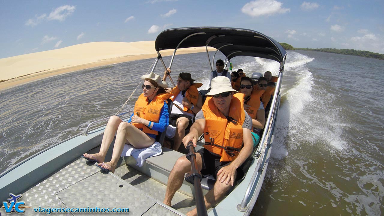
5. Preguiças River Trip
You can cross the Preguiças River in the Lençóis Maranhenses National Park by speedboat or voadeira – a fast boat with a motor at the stern, interspersed with attractions.
Caburé é um vilarejo de pescadores no Maranhão
The first are the 40 metre high dunes that rise at Vassouras, a fishing village reached after a 45 minute sail.
Here you can choose between a dip in the river or a walk along the Pequenos Lençóis beach. The next stops are Espadarte, Morro do Boi and Moitas.
Next stop is the village of Mandacaru, where you’ll find the Preguiças lighthouse, with 160 steps. It’s well worth the effort, as the top offers one of the best views of the region.

Then there’s a lunch break in Caburé, near the mouth of the Preguiças River, an unattractive town only visited for its restaurants.
6. Lagoons
After crossing the Preguiças River, you will board a jeep and head for the lagoons of the Lençóis Maranhenses National Park.
Once off the ferry, the car follows a winding road between lakes and streams, some of which are flooded.

In 40 minutes you reach a point where you have to walk.
Another five minutes and you reach the Preguiça Lagoon, with its turquoise waters.
Another ten minutes’ walk takes you to the beautiful Blue Lagoon, which lives up to its name.
One of the most popular spots in the park, it is often crowded – if you want to relax, you can walk another ten minutes to the Peixe Lagoon, which is one of the only lagoons that does not dry up in summer (the Azul Lagoon simply disappears at the end of the year).

Surrounded by vegetation and dark green waters, it precedes the famous Bonita Lagoon, surrounded by dunes up to 40 metres high. To reach it, take another winding road for about an hour.
7. Flight over the Park
For 30 minutes, a twin-engine plane flies over the Lençóis Maranhenses National Park.
After taking off from Barreirinhas, the flight takes in a panoramic view of the region and reaches the mouth of the Preguiças River at Atins. The aerial view of the vast expanses of dunes and lagoons is unforgettable.
8. Atins
The village of Atins, in the Lençóis Maranhenses National Park, is where the Preguiças River ends and flows into the sea.

Atins, which can be reached with guides from agencies in Barreirinhas, marks the beginning of the so-called Great Lençois Beach, a region that ends 100 kilometres away, in Travosa, at the other end of the Lençóis Maranhenses National Park.
Village life
The small fishing village got electricity a few years ago and still lives from fishing. There are no cars on the sandy streets, and a single public telephone keeps the world connected.
Magical atmosphere
For all these reasons, Atins retains a magical atmosphere, enhanced by its special geographical location: Situated between the River and the Sea, next to the Dunes of the Park and with a Beach that, depending on the Tides, is adorned with natural saltwater pools.
Natural attractions
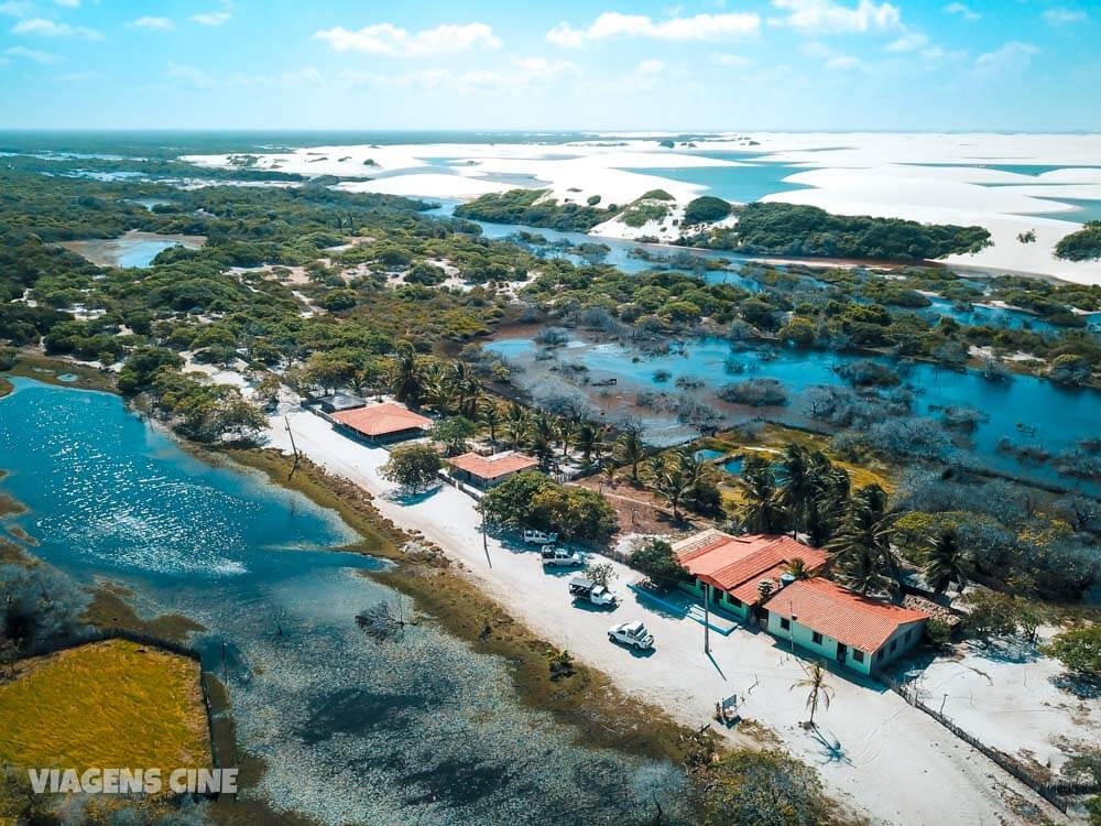
The village is home to attractions such as the Pedras Fountain, which emerges from a vast expanse of sand in a unique shade of turquoise blue, and the Mário Lagoon, in whose dark waters float white water flowers. At the edge of the lagoon, Mrs Luzia serves incomparable prawns from her stall.
9. Queimada dos Britos
One hundred inhabitants, 5,000 goats – goat rearing is one of the main economic activities in the area – beautiful dunes and lagoons.
This is Queimada dos Britos, a village within the Lençóis Maranhenses National Park.

A green area embedded in the sand, it resembles an oasis, with very simple thatched houses and still no electricity.
The village can be reached in two hours by jeep or eight hours on a difficult hike through the sand.
Near Queimada dos Britos is Baixa Grande, another lush green area in the middle of the sand.
This area benefits from the presence of the Negro River, which cuts through the entire National Park from north to south. Its source is the Esperança Lagoon, another of the park’s beautiful attractions.
Best time to visit
The best times to visit Lençóis Maranhenses National Park are
- May to September: This is considered the ideal time to visit the park. During these months it rains and the lagoons fill up, creating the characteristic landscape of freshwater lagoons between the dunes. Temperatures are pleasant and vegetation is lush and green.
- June and July: These months are particularly popular with tourists as the lagoons are at their highest, providing an incredible visual spectacle. The weather is also milder, making outdoor activities more enjoyable.
- October to April: Although it is possible to visit the park during these months, it is the dry season and the lagoons tend to be shallower or even dry, especially towards the end of the period. However, the dunes are still impressive and the weather is warm and sunny.

In short, the best time to visit the Lençóis Maranhenses National Park is from May to September, when the lagoons are full and the scenery is at its most breathtaking.
Publicações Relacionadas
Santo Amaro do Maranhão: The Paradise of the Lagoons
Exploring Caburé: The Enchanting Peninsula of Maranhão
Access to the Lençóis Maranhenses National Park
Atins: A Hidden Gem on the Maranhão Coast
Kitesurfing in Atins: Your Ultimate Guide
Best Time to Visit Lençóis Maranhenses for Water Fun
Barreirinhas: the gateway to Lençóis Maranhenses
This post is also on:
![]() Português
Português ![]() English
English ![]() Deutsch
Deutsch ![]() Español
Español ![]() Français
Français


