


Overview
Salinas da Margarida is a coastal municipality in the Recôncavo Baiano, situated on the shores of Baía de Todos os Santos.
Traditionally associated with salt production (which began in 1881 at Porto da Margarida), its economy today combines fishing, shrimp farming, tourism and local crafts.
- Population: IBGE estimate for 2025 — 15,629 inhabitants (IBGE)
- Area: 148.33 km² (municipal); approximate land area: 65 km² (source: municipal council)
- Districts and villages: Dendê (Porto da Telha), Encarnação, Conceição de Salinas, Cairu and Barra do Paraguaçu
")
")
")
Main attractions

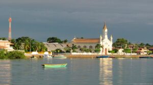
Cidade de Salinas da Margarida na Bahia

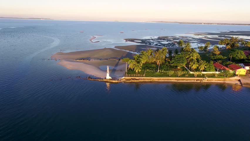
Barra do Paraguaçu na Bahia
Barra do Paraguaçu - Salinas da Margarida03:42
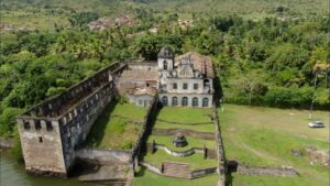
Ruínas do Convento e Igreja de Santo Antônio do Paraguaçu
Tourism in Salinas da Margarida centres on beaches, boat trips and seafood cuisine.
Jetty at Ponte Beach
A central spot with a promenade, kiosks and views of the bay — perfect for sunsets and meals by the sea.
Recommended beaches
There are at least 10 beaches suitable for swimming. The most popular ones are:
- Barra do Paraguaçu Beach — warm, calm sea; activities: swimming, kayaking, angling; near the Cavalo Russo stream (freshwater).
- Ponta da Telha
- Ponta do Dourado
- Cairu
- Conceição de Salinas
- Encarnação — mangroves, white sand; crab fishing with a gereré net and collecting small crabs.
- Pedra Mole, Camborui, Tubarão and Praia do Amor
Crafts and culture
Cuisine
The cuisine features shellfish and crustaceans. Typical dishes include moqueca, pirão, black-eyed peas, farofa and chilli — all of which are widely available at the stalls along the promenade.
Barra do Paraguaçu
A village located in the municipality, on the banks of the Paraguaçu River, ideal for those seeking nature and history.

")
- Ruins of the Convent of São Francisco do Paraguaçu: a 17th-century historic site frequently visited on tours of the Paraguaçu basin; please note — the most frequently mentioned ruins are located along the river in areas linked to the municipality of Cachoeira/São Francisco do Paraguaçu, and are often included in itineraries that pass through Barra do Paraguaçu (Salinas). Consult local guides when planning your visit.
- Boat trips on the Paraguaçu River — birdwatching, mangroves and riverside scenery.
Tours of the Bay
The Salinas jetty accommodates private boats and sightseeing tours of Todos os Santos Bay; excursions depart from Salvador and are operated by private boats during specific seasons.
How to get there
- By car (overland route): approximately 250–270 km from Salvador, travelling around the bay (depending on the route).
- By ferry (Itaparica) + road journey: reduces the distance travelled by road (varies depending on the boarding point — check timetables and terminals).
- By boat: tours and transfers around Todos os Santos Bay with private operators.
Publicações Relacionadas
Madre de Deus: a paradise in the Recôncavo Baiano
Discover the beauty and diversity of the Bay of All Saints
City of Cachoeira: Bahia's Hidden Historical Treasure
Maré Island (Bay of Todos os Santos) — beaches, culture and how to get there
Candeias: History of the Feast of Our Lady
Bay of Todos os Santos: nature, history and cultur
Tourism in São Francisco do Conde (BA) — Tips and Attractions
Itaparica Island — Complete Guide: History, Beaches and Tips
Todos os Santos Bay: Nature, History, Culture and Tourism
Island of Fear: Mysteries and Hauntings
Santo Amaro in the Recôncavo Baiano and its history
Todos-os-Santos Bay (Bahia) — History, geography and conservation
History and Heritage of Itaparica Island — Bay of Todos os Santos
Tourist information about Bom Jesus dos Passos Island
Tourist Guide to the Pantanal in Bahia — Jaguaripe (BA) | Mangroves, Fishing and Excursions
Main islands of Todos os Santos Bay
Ilha dos Frades — History, beaches and tourist attractions
This post is also on:
![]() Português
Português ![]() English
English ![]() Deutsch
Deutsch ![]() Español
Español ![]() Français
Français


