Island of Fear (Baía de Todos os Santos) — History, Legends and Environmental Protection
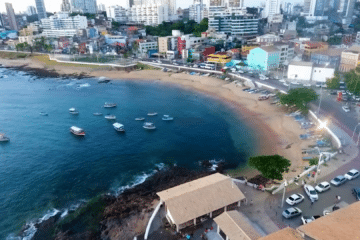
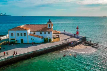
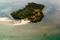
Island of Fear is a small island situated in Baía de Todos os Santos, in the state of Bahia. Known for its mysterious name, the island combines history, ancient ruins and nature reserves — attracting researchers, nature lovers and those interested in local legends.


Administrative location and significance
Ilha do Medo belongs to the municipality of Itaparica and is situated to the north of Itaparica Island. It forms part of the archipelago in Baía de Todos os Santos and lies within areas protected by environmental legislation.
Video about the Island of Fear
Ilha do Medo na Baía de Todos os Santos
See the map of Todos os Santos Bay
Environmental protection
The island and its surrounding area were designated as an Ecological Station in 1991, and were recognised as the first ecological station in Baía de Todos os Santos. The area also forms part of the Baía de Todos os Santos Environmental Protection Area (APA), which restricts land use and visitor access in order to preserve biodiversity.
Dimensions and the natural environment
It is a small, uninhabited island, covering an area of around 12,000 m², covered in dense vegetation, with patches of mangrove forest and well-preserved coastal formations. The environment supports species typical of the region and helps to protect both marine and terrestrial flora and fauna.
History and ruins
In the past, the island was used for military purposes and was home to facilities where patients with leprosy were confined (a colony or leprosarium). Ruins remain that bear witness to this period and provide material for both historical studies and folk legends.
Origin of the name and legends
The name ‘Ilha do Medo’ is linked to local tales: accounts of hauntings attributed to former patients, stories of fishermen who heard noises and voices at night, and tales involving shipwrecks or invaders. These tales form part of the region’s folklore.
Access and recommendations
The island is usually accessed by private boat from Itaparica or Salvador. As the island forms part of a conservation area and the APA, visits may be restricted or limited to research and conservation purposes — please check with local authorities before planning your trip and use authorised operators.
What to see on the Island of Fear
- Historic ruins (military installations and structures linked to the former leprosarium).
- Stretches of mangrove and native coastal vegetation.
- Birdwatching and observing the marine wildlife typical of Todos os Santos Bay.

Frequently Asked Questions (FAQ)
1. Can I visit Ilha do Medo?
It depends: the island is situated within a protected area, and visitor numbers may be restricted. Please check with Itaparica Town Hall, local environmental authorities or authorised tour operators before planning your visit.
2. Why is the island called ‘Island of Fear’?
The name stems from local folklore and historical accounts of the confinement of the sick, hauntings and past events. There is no single, established official explanation.
3. Is the island inhabited?
No. Fear Island is uninhabited and has no permanent source of fresh water, which has contributed to its sparse population.
4. Is there a risk in visiting because of the ‘hauntings’?
Ghost stories are part of folklore; there is no scientific evidence of supernatural phenomena. Always prioritise safety, comply with environmental regulations and follow official guidance.
Final recommendations
- Check with Itaparica Town Hall and the relevant environmental authorities for any restrictions before you go.
- Hire a qualified and locally recommended boat operator.
- Please observe the signs, do not collect artefacts or archaeological material, and do not disturb the wildlife.
- Take water and sun cream with you, and take your rubbish away — practise responsible tourism.
For maps and further information, please refer to local guidebooks and reference works on Todos os Santos Bay and the heritage of Itaparica.

Publicações Relacionadas
Monte Pascoal National Park: Pataxó culture and Brazilian history
Praia do Forte, Bahia: The Complete Travel Guide
Santa Cruz Cabrália in Bahia — beaches, history and things to do
Torrinha Cave: A Speleological Marvel in Brazil
Serra Grande: Your Guide to Bahia's Paradise
Tourism in São Francisco do Conde (BA) — Tips and Attractions
Rafting in Taboquinhas: The Ultimate Adventure Guide
How to get to Fumaça Waterfall in Chapada Diamantina
Find out how to celebrate Carnival in Salvador, Bahia
Valença: The Gateway to Morro de São Paulo
Barra do Cahy: Brazil's first beach - history and nature
Maraú Peninsula: Explore Its Stunning Beaches
Churches of Salvador: Architectural and Historical Treasures
Maré Island (Bay of Todos os Santos) — beaches, culture and how to get there
Canavieiras: A Hidden Gem in Bahia's Coastline
Things to Do in Nova Viçosa (Bahia): Beaches, Islands and Abrolhos
Lauro de Freitas — A comprehensive guide to beaches, culture and leisure
Chapada Diamantina: A Complete Guide to Attractions and Itineraries
Cumuruxatiba (Prado, BA) — Guide to beaches, excursions and whale watching
Cocoa farms attract tourists to Bahia - Chocolate Road
Tourist Guide to the Pantanal in Bahia — Jaguaripe (BA) | Mangroves, Fishing and Excursions
Coast of Discovery: Bahia's Historical Treasures
Todos os Santos Bay — Nature, History and Water-based Tourism
Camamu Bay — A Hidden Paradise in Bahia
Tourist Areas in Bahia - Tourist Guide
Rio de Contas: Learn about the history of how the city was founded
Massarandupió Naturist Beach in Bahia
Bahia Art Museum (MAB): Learn about its history and collection
Rio Vermelho is Salvador’s trendiest and most bohemian neighbourhood
São Sebastião Cathedral (Ilhéus) — History, architecture and tourism
Lacerda Elevator — history, construction and visits
A History of the Forts and Lighthouses of Salvador (Bahia)
São Jorge Parish Church in Ilhéus — history, architecture and religious art
Arembepe: beaches (Piruí, Praia do Canto), Hippie Village and the Tamar Project
Sempre-Viva: Symbol of Preservation in the Chapada Diamantina
Santo Amaro da Purificação — History, Culture and Tourism in the Recôncavo Baiano
This post is also on:
 Português
  English
  Deutsch
  Español
  Français