The São Pedro e São Paulo Archipelago is a group of small rocky islands in the central part of the equatorial Atlantic Ocean, 627 kilometres from the Fernando de Noronha Archipelago, 986 kilometres from the nearest mainland point and 1010 kilometres from Natal, in the state of Rio Grande do Norte.
It has been declared as part of the Brazilian territory, according to the IBGE, belonging to the state of Pernambuco, although it is closer to the state of Rio Grande do Norte.

The São Pedro and São Paulo Archipelago Programme (Proarquipélago), managed by the Secretariat of the Interministerial Commission for Marine Resources (SECIRM), began in 1998 with the inauguration of the scientific station on Belmonte Island.
The permanent presence of scientists at the scientific station is necessary to prove the habitability of the archipelago, which is essential for its international recognition as Brazilian territory.
Finally, expeditionary radio amateurs, supported by the Armed Forces, establish international contacts via HF radio and satellite, reinforcing Brazil’s presence in the region.
Arquipélago de São Pedro e São Paulo12:47

Arquipélago de São Pedro e São Paulo - Reportagem

Arquipélago de São Pedro e São Paulo - Documentário32:41
Formerly popularly known as “Penedo de São Pedro e São Paulo” or “Rochedo de São Pedro e São Paulo”, it is now officially called “Arquipélago de São Pedro e São Paulo”.
The exposed rock is peridotite and serpentinised peridotite, probably from a tectonised megamullion, and is the only exposure of the abyssal mantle above sea level in the world.
The archipelago is actively uplifted at a rate of 0.7 mm per year.

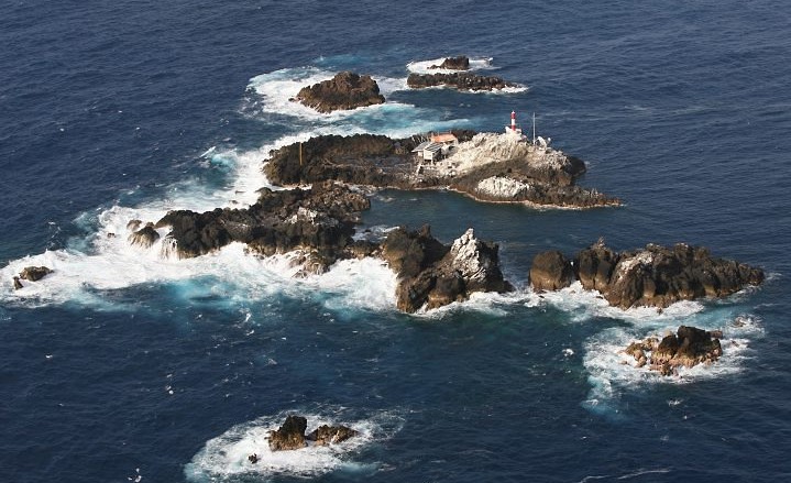
Location of the São Pedro and São Paulo Archipelago

The São Pedro and São Paulo Archipelago is located in the equatorial region of the Atlantic Ocean, N00º55.1′, W29º20.7′, about 1010 kilometres ENE of the city of Natal, in the state of Rio Grande do Norte (RN).

The total underwater area is about 13,000 square metres, with a maximum depth of 18 metres. It is made up of five larger islands and numerous rocks, making it one of the most inhospitable places in the country.
The 5 largest islands of the São Pedro and São Paulo Archipelago are
- Belmonte Island (Southwest): 5,380 m²
- Challenger Island (southeast of São Paulo): 3,000 m²
- Northeast Island (São Pedro, Northeast): 1,440 sq.m.
- Cabral Island (Northwest) 1,170 m²
- South Island: 943 sq km
None of the islands have potable water. Only the largest island has sparse vegetation.

The cliffs are home to several species of seabirds (such as Anous minutus, Anous stolidus and Sula leucogaster), which cover them with their droppings, forming guano, a type of natural organic fertiliser.
Other species that may be related are crabs (such as Grapsus grapsus) and various species of insects and spiders.
History of the São Pedro and São Paulo Archipelagos
Darwin’s trail, the archipelago in the centre.

The rocks were discovered by chance by Portuguese navigators when the Armada of 20 April 1511, made up of six caravels under the command of Captain Major Garcia de Noronha, on its way to India, recorded its first shipwreck there (according to the Book of the Armadas, only two of its ships reached their destination).
Sailing in the open sea during a closed night, a sudden roar of waves was heard and before any action could be taken, the “São Pedro”, under the command of Captain Manuel de Castro Alcoforado, found itself stranded on a rock with its bottom open.
The crew was rescued by another caravel from the same squadron, the “São Paulo”, and the episode gave the rocks their name.
They first appeared on a Spanish map in 1513 by the navigator Juan da Nova Castello, and later on another in 1529 by the Portuguese navigator Diego Ribero.
The first recorded landing on the rocks was that of the Frenchman Bouvet du Losier (1738), followed by the American Amasa Delano, in command of the “Perseverance” (1803), and the British George Criton, aboard the “HMS Rhin”.

Its most famous visitor, however, was Charles Darwin, who landed there on the morning of 16 February 1832, on the first leg of his circumnavigation of the globe aboard the HMS Beagle.
The first photographs of the cliffs were taken by the crew of the “Scotia” on a trip to Antarctica in 1902. A little later, in 1911, the crew of the “Deutschland” began to study them. The Irishman Ernest Henry Shackleton (1874-1922) also passed through in 1921 aboard the Quest (Shackleton-Rowett Expedition 1921-1922).
Other famous visitors were Gago Coutinho and Sacadura Cabral, who docked there in 1922 with the Lusitânia to refuel the Portuguese Navy cruiser República.
In 1930, the Brazilian Navy ship “Belmonte” installed the first lighthouse, a task that took a year to complete. An earthquake partially destroyed this lighthouse in 1933, and the current lighthouse was inaugurated in 1995.
The area was visited by American ships during the Second World War and by foreign scientists in the 1960s. It was not until 1996 that Brazil began to occupy the cliffs permanently.
On the night of 31 May to 1 June 2009, Air France flight 447 from Rio de Janeiro to Paris crashed near the archipelago, killing 228 people on board.
Brazilian Navy in the São Pedro e São Paulo Archipelago
Although inhospitable to human life, recent interest in the archipelago has been stimulated by Brazil’s signature of the United Nations Convention on the Law of the Sea (UNCLOS), which states in Article 121, paragraph 3, that “rocks which are not in themselves suitable for human habitation or economic life shall have neither an exclusive economic zone (EEZ) nor a continental shelf”.
Although the archipelago has always been the subject of research to determine its fishery resources, the physical, chemical and biological parameters of its waters and to collect meteorological data, in 1995 the Brazilian Navy began building a new lighthouse there with the aim of reducing the number of shipwrecks in these waters due to the poor visibility of the rocks, which have a maximum height of 18 metres and are constantly battered by the waves.
The original lighthouse was built on the islet of Belmonte in 1930 by the crew of the Belmonte, under the command of Commander Álvaro Nogueira da Gama.
The work was interrupted by the outbreak of the revolution in 1930 and was not completed until 1931, only to be destroyed and abandoned in 1933, probably by a tectonic tremor.
The present lighthouse stands on the south-western rock. It is automatic, made of fibreglass, with a circular section one metre in diameter and six metres high.
At the same time, work began on the construction of a building that would serve as a base for a group of researchers to carry out oceanographic and environmental research on the rocks, known as the Archipelago Programme.
With the support of the Navy, four voyages were made to the archipelago to study physical and environmental aspects, topography, bird behaviour and more, leading to the creation of the São Pedro and São Paulo Archipelago Scientific Station (ECASPSP), inaugurated in 1998.
Here, in a 45 square metre wooden building, teams of four scientists and researchers rotate every two weeks with the support of the Brazilian Navy.
Facilities include a kitchen, dining room, communication centre, bedroom for four, bathroom and balcony. There are photovoltaic panels on the roof to generate electricity.
A short distance away is a shelter for the generators and batteries, seawater desalination equipment and another shelter for oxygen and gas cylinders. A walkway connects the base to the embarkation point, which is served by a davit. The base’s scientific equipment includes a tide gauge.
On 5 and 6 June 2006, the station was partially destroyed by a violent storm. However, the station was immediately rebuilt according to the new structure.
History and geography of the São Pedro and São Paulo archipelagos
Publicações Relacionadas
Itamaracá Island: Best Attractions and Activities
Jararaca-ilhoa: Endemic Species of Queimada Grande
Alcatrazes Archipelago: Secrets of Evolution Revealed
Ilhabela: A Tropical Paradise Awaiting You
Anchieta Island: History, Beaches, and Nature
Ponta do Boi Lighthouse: History and Significance
Trindade and Martim Vaz: Discovering the Archipelago
Atol das Rocas - Origin, biology, climate and shipwrecks
Florianópolis: A Blend of Urban and Natural Beauty
History of the island of Itaparica in the Bay of All Saints
Ilha Grande: The Ultimate Tropical Paradise
Marajó Archipelago: A Unique Ecological Paradise
Brazil has oceanic and continental islands
This post is also on:
![]() Português
Português ![]() English
English ![]() Deutsch
Deutsch ![]() Español
Español ![]() Français
Français