Map of Brazil from 1850 The maps in The Illustrated Atlas were first published in serial form for an audience isolated by the cost and difficulty of travel. All this changed as the 19th century brought rapid and dramatic changes in public awareness of distant places. Tallis’s maps undoubtedly played […]
Posts — Travel Guides and Tips for the North-East and Brazil | Bahia.ws
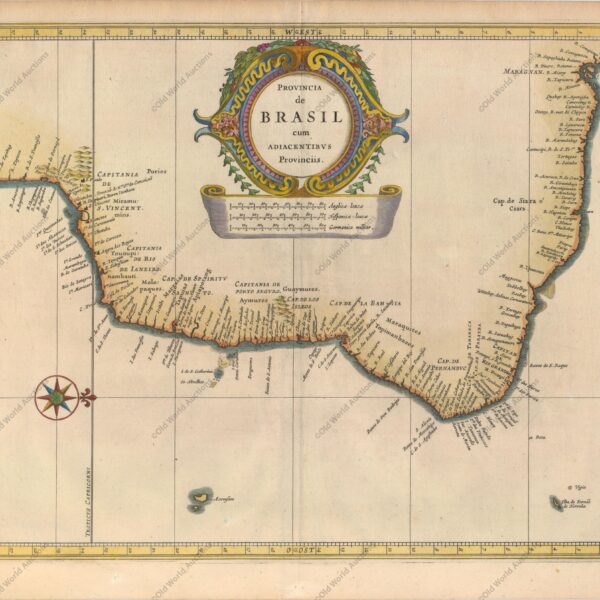
Map of the East Coast of Brazil, 1647 – Historical Maps
Map of the East Coast of Brazil from 1647 This beautiful map of the Brazilian coast is decorated at the top with a huge garland of native fruits and a jaguar, tapir and capybara. With north to the right, the map covers the coastal region from São Francisco south to […]
Map of Brazil 1554 – Historical Maps of Brazil
Map of Brazil from 1554 This fascinating pictorial map is one of the first regional maps of Brazil available. Illustrated with north to the right, the map is filled with vignettes depicting native life rather than focusing on geographical information. Indians are shown with bows and arrows, axes, llamas and […]
Map of Brazil 1747 – Historical Maps of Brazil
Map of Brazil from 1747 Copper engraved map with good detail along the coast with dozens of place names. The map covers the region between northern Paraguay and north to the mouth of the Amazon. A large inset of St Catherine’s Island fills the empty ocean. In a long note […]
Discover Pedro II: the enchanted Switzerland of Piauí
Discover the City of Pedro II: Nature, Culture and History in Piauí The city of Pedro II, known as the Switzerland of Piauí, is a charming city located in the north of Piauí, about 200 kilometres from Teresina, the capital of Piauí. The city is famous for its mild climate, […]
Opal: Meaning, Properties and Characteristics
The opal is one of the world’s most admired gemstones, and Brazil has its own source of precious opal in Pedro II, in Piauí. In this guide, you’ll find out about the meaning of opal, its properties and characteristics, the different types and colours, the opal from Pedro II (Piauí), […]
Map of Cabo Santo Agostinho from 1645 – Historical Map of Brazil
Map of Cape St. Augustin from 1645 This beautiful copper engraved map shows the harbour and fortifications of Cabo Santo Agostinho. Fort Nazaré is shown on a hill to the right. Decorated with a compass pointing north at the top right of the map and a title cartouche in stripes. […]
1671 engraving of Fort Orange on the island of Itamaraca
Orange fort on the island of Itamaraca, 1671 “I. Tamaraca”, Montanus, Arnoldus Montanus’ work was perhaps the largest illustrated book on the New World produced in the 17th century. It contained more than one hundred beautifully engraved plates, views and maps of North and South America. The plates vividly depicted […]
Engraving of the Fort of the Three Kings in Natal, 1671
Engraving of the Fort of the Three Kings in Natal, 1671 Montanus’s work was perhaps the largest illustrated book on the New World produced in the 17th century. It contained more than one hundred beautifully engraved plates, views and maps of North and South America. The plates vividly depicted forts, […]
Reis Magos Fort Engraving from 1690 – Engravings Stories
Engraving of the Fort Reis Magos from 1690 – Natal An aerial view of the fort (now Natal) at the mouth of the River Potengi, showing the Dutch invasion and capture of the Portuguese fort in 1633. The harbour is full of ships and armies are shown rushing to defend […]
Engraving of the Bay of Todos os Santos from 1690 – Historical Engraving
Engraving of the Bay of Todos os Santos from 1690 A beautiful copper engraving depicting the Dutch fleet capturing the fort at the entrance to Todos os Santos Bay, in north-eastern Brazil. The scene is very lively, with billowing cannons and small figures rushing into the fray. A close-up of […]
Map of Cabo de Santo Agostinho from 1690
Map of Cape St. Augustin from 1690 This beautiful panoramic view shows the Dutch fleet and the fortifications of Cape St Augustine. The strapwork title cartouche contains a numbered key identifying four locations. – “Afbeeldinge vande Cabo St. Augustin met Haer Forten”, Leti, Gregorio Map of Cabo de Santo Agostinho […]
Map of Paraíba of 1690 – Historical Maps of Brazil
Map of Paraíba from 1690 This panoramic map shows the region of Paraíba and the Portuguese fortifications at the mouth of the Paraíba River. The scene of the Dutch attack on the region is illustrated with the Dutch fleet and the defence of the Portuguese armies. “Afbeeldinghe van Pariba ende […]
Map of Brazil from 1630: Cartography’s Legacy
Map of Brazil from 1630 This beautiful map was a collaboration between Hessel Gerritsz, official cartographer of the Dutch East India Company, and Johannes de Laet, director of the newly formed Dutch West India Company. His maps of South America laid the foundations for many other cartographers. The detail is […]
Map of Brazil from 1652: A Historical Perspective
Map of Brazil from 1652 Beautiful depiction of Brazil with north oriented to the right by a beautiful compass rose. The map shows two regions of Dutch interest in the area, Baía de Todos os Santos and Pernambuco. The interior is devoid of geographical information, except for largely imaginary rivers […]
Igarassu: Discover the historic city of Pernambuco
Igarassu is a historic city in the state of Pernambuco, Brazil. It is one of the oldest cities in the country, founded in 1535. The city is known for its rich cultural heritage and colonial architecture, especially its historic churches. The city of Igarassu is located in the state of […]
Engenhos de Pernambuco: História do Início ao Fim
Engenhos de Pernambuco em resumo Início: a produção de açúcar começou com a capitania de Pernambuco, entregue a Duarte Coelho em 1534, e Pernambuco tornou-se a capitania mais próspera do Brasil. Onde ficavam: sobretudo na Zona da Mata, perto do porto do Recife, de rios e de matas para lenha. […]
Engraving of Salvador from 1671: A Historical Insight
Engraving of Salvador from 1671 Montanus’s work was perhaps the greatest illustrated book on the New World produced in the 17th century. It contained over a hundred beautifully engraved plates, views and maps of North and South America. The plates vividly depicted forts, festivals, occupations, Dutch fleets, battles, religious rites […]
Engraving of Todos os Santos Bay from 1671 Explained
Engraving of Todos os Santos Bay from 1671, Brazil Montanus’s work was perhaps the greatest illustrated book on the New World produced in the 17th century. It contained over a hundred beautifully engraved plates, views and maps of North and South America. The plates vividly depicted forts, festivals, occupations, Dutch […]
Map of Brasil from 1757: Historic Coastal Views
Map of Brazil from 1757 – L’Histoire Generale des Voyages… “[Lot of 2] Suite du Bresil Depuis la Baye de Tous les Saints Jusqu’a St. Paul [and] Suite du Bresil pour Servir a l’Histoire Generale des Voyages”, Bellin, Jacques Nicolas This pair of copper engraved maps covers the coastline of Brazil […]