Map of the Western Hemisphere, 1659 This is a very rare derivative of the important Hondius map of 1618. The engraver is unknown, although it is closely copied from Picart’s version of 1644, which in turn was derived from Jansson’s map of 1623. North America retains the peninsula of California, […]
Posts — Travel Guides and Tips for the North-East and Brazil | Bahia.ws
1581 Map of the Western Hemisphere – Historical Map
Map of the Western Hemisphere of 1581 This is one of the most famous maps of the Americas, and one that had an enormous influence on future cartography of the New World. The map is largely based on Gerard Mercator’s large multi-sheet world map of 1569. The most recognisable features […]
Tourmaline: Varieties, Properties and Characteristics
Tourmaline is one of the gemstones most commonly used by jewellery designers, as it comes in almost every colour – and often features more than one colour within a single stone. In this guide, you’ll find out what tourmaline is, its gemmological properties and characteristics, the main varieties (Paraíba, indicolite, […]
Identifying a Precious Stone or Gemstone: A Comprehensive Guide
Knowing how to identify a precious stone or gemstone is becoming increasingly important, as imitations and lab-grown gemstones are getting better and better. In this guide, you’ll learn the difference between natural, synthetic, artificial and imitation gemstones, discover the main Brazilian gemstones (beryls and tourmalines) and learn how to use […]
1659 Map of the Western Hemisphere – Historical Map
Map of the Western Hemisphere, 1659 This is a very rare derivative of the important Hondius map of 1618. The engraver is unknown, although it is a close copy of Picart’s version of 1644, which in turn was derived from Jansson’s map of 1623. North America retains the peninsula of […]
Map of the Brazilian Coast from 1678 – Historical Map of Brazil
Map of the Coast of Brazil from 1678 This splendid map of Brazil is mainly a nautical chart with details limited to the coastline. Oriented with north to the left by two fine points of the compass, it covers the Brazilian coast from the mouth of the Amazon to the […]
Map of eastern Brazil 1664 – Historical Map of Brazil
Map of Eastern Brazil 1664 This beautiful map of the Brazilian coast is richly decorated with a scene of natives with a watchtower and a huge fleet of ships. With north to the right, the map covers the coastal region from São Francisco to Recife. It was based on real […]
Map of South America from 1750 – Historical Maps of Brazil
Map of South America from 1750 Beautifully engraved Italian edition of Delisle’s map of South America, extending from Nicaragua to Tierra del Fuego. The place names of South America are mainly concentrated on the coasts and along the Amazon and Paraná rivers. There are also two mythical lakes: Lake Cassipa […]
Map of Brazil 1698 – Historical Maps of Brazil
Map of Brazil from 1698 This magnificent map of Brazil, including parts of neighbouring countries, was one of 23 maps in this rare account of the Portuguese-Dutch colonial war. Written by João José de Santa Teresa, known to bibliophiles as Saint Teresa, it is considered one of the most sumptuous […]
Map of Brazil from 1750 – Historical Map of Brazil
Map of Brazil from 1750 This is a beautiful Italian map of Brazil based on Delisle’s cartography. There is very good detail along the coast and a good amount of information about the interior with numerous annotations and locations of indigenous tribes. The map is decorated with a large pictorial […]
1639 Map of Paraíba – Historical Map of Brazil
Map of Paraíba from 1639 A splendid map of the Paraíba region and the defensive forts at the mouth of the Paraíba River. The map illustrates the Dutch invasion of Portuguese territory, showing the Dutch fleet filling the river and the defending armies marching along the roads. A large and […]
Map of Brazil divided into fourteen hereditary captainships from 1657 onwards
Map of Brazil divided into fourteen hereditary captaincies from 1657 onwards “Le Bresil, dont la Coste est Possedee par les Portugais, et Divisee en Quatorze Capitaineries…”, Sanson, Nicolas Map of Brazil divided into fourteen hereditary captaincies, 1657 – This is a reduced version of Sanson’s important map showing the Portuguese […]
Map of the Captaincy of Paraíba and Rio Grande, 1720
Map of the Captaincy of Paraíba and Rio Grande from 1720 Excellent map of the Brazilian coast, including the captaincies of Paraíba and Rio Grande. The map was drawn after real research by Georg Markgraf, Elias Herckmanns and others and was one of the first maps of Brazil based on […]
Map of All Saints Bay 1769 – Historical Maps
Map of the Bay of All Saints, 1769 This map is a boldly engraved graphic of the Bay of Salvador (Bahia) with an inset plan of the fortified city of Salvador. Navigational soundings and shoals are shown in the bay. Numerous plantations and sugar mills are marked with symbols along […]
All Saints Bay Map of 1644 – Historical Map
Map of the Bay of All Saints, 1644 This rare map of Salvador and the Bay of All Saints shows the Dutch attack and capture of the city of Salvador in May 1624. Salvador, then the capital of Brazil, was a strategic port under Portuguese control. The Dutch, determined to […]
Engraving of Cabo Santo Agostinho from 1645 – Historical Engravings
Engraving of Cape St. Augustin from 1645 This beautiful panoramic view shows the Dutch fleet and the fortifications of Cape St. Augustin. Published by Gregorio Letie, this scene was copied from an earlier publication dating from around 1640. It’s interesting to note that the image was inverted during the engraving […]
Engraving of Sirinhaém from 1671
Engraving of Sirinhaém, 1671 Montanus’ work was perhaps the largest illustrated book on the New World produced in the 17th century. It contained more than one hundred beautifully engraved plates, views and maps of North and South America. The plates vividly depicted forts, festivals, occupations, Dutch fleets, battles, religious rites […]
Engraving of Salvador de Bahia from 1770 – Historical Maps
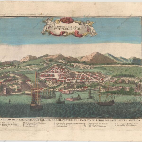
Copper engraving of Salvador de Bahia, 1770 Salvador, the former capital of Brazil, was a strategic port under Portuguese control. This beautiful engraving shows the walled city of Salvador with ships and boats filling the harbour in the foreground. A key of letters at the bottom identifies various locations. This […]
Map of the Brazilian coast from the Paraíba River to Cabo de Santo Agostinho
Map of the Brazilian coast from Rio Paraíba to Cabo de Santo Agostinho, 1683 “Pas-Kaart, van de Zee-Kusten, van, Brazilia, Tusschen, Punto de Lucena en Cabo S. Augustino”, Keulen, Johannes van This rare and classic sea chart covers the Brazilian coast from the river Paraíba to Cape St. Augustino. Augustino. […]
1757 Map of the Western Hemisphere
1757 Map of the Western Hemisphere This beautiful map of the Americas includes the Solomon Islands. In North America, the Pacific Northwest is left open, completely blank and marked Undiscovered Parts. The coastline ends near Alaska with the note The Alleged Strait of Annian. The British colonies are shown east […]