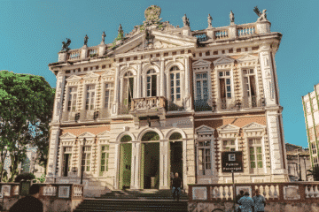
Olinda Cathedral: History and Architecture The Olinda Cathedral, also known as the Church of Saint Saviour of the World, is located in the Historic Site of Olinda and occupies a prominent position in the city’s landscape. As well as being the first religious building constructed by the Portuguese on their […]
Posts — Travel Guides and Tips for the North-East and Brazil | Bahia.ws
Birds of the Chapada Diamantina: endemics and where to see
The birds of the Chapada Diamantina attract birdwatchers from Brazil and abroad. In fact, checklists for the region include hundreds of species, and some estimates exceed 400. In addition, some birds live only there, such as the hooded visorbearer, the Diamantina tapaculo and the Sincorá antwren. Next, in this guide, […]
Franciscan Monastery of Olinda: A Historic Landmark
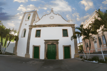
Although they had been present in Brazil since the first Portuguese expeditions, the Franciscans did not settle here permanently until several decades later. In this respect, the Franciscan Monastery of Olinda is considered the oldest establishment of the disciples of St Francis on Brazilian soil, the cradle of the Order […]
Towns of the Chapada Diamantina: where to stay
The Chapada Diamantina is not a town: it is a region in the center of Bahia, made up of several municipalities. Therefore, the towns of the Chapada Diamantina serve as bases for exploring the Chapada Diamantina National Park, which protects about 152,000 hectares of waterfalls, caves and archaeological sites. Thus, […]
Solar do Unhão and MAM-BA: History, Sunset and Visit
Solar do Unhão is a colonial complex on the shore of the Bay of All Saints, in Salvador, that houses the Museum of Modern Art of Bahia (MAM-BA). In addition, it is one of the most beautiful places in the city to watch the sunset over the sea. In this […]
Gamboa in Salvador: Gamboa de Baixo, beaches and sunset
Gamboa, in Salvador, is a community on the shore of the Bay of All Saints, long inhabited by fishermen, close to the Historic Center. It lies between the Solar do Unhão and Campo Grande, below and above Avenida Contorno. So, in this guide, you will find Gamboa de Baixo, the […]
Avenida Contorno in Salvador: history, arches, sights
Avenida Contorno, in Salvador, links Campo Grande to the Lower City along the hillside, always facing the Bay of All Saints. In addition, its concrete arches are a landmark of modern Bahian architecture. That is why some of the most beautiful places in the city lie along it, such as […]
Map of Olinda in Pernambuco from 1640 – Historical Map
Map of Olinda in Pernambuco from 1640 This map shows two views of the Portuguese sugar colonies in Brazil during the Dutch invasion in 1630. The top view shows the Dutch fleet attacking the port and fort. Below is a plan of the town of Olinda and its surroundings, with […]
Jade: Meaning, Properties and Characteristics
Jade is a gemstone that has been used since prehistoric times and is prized in many cultures. In this guide, you will learn about the meaning of jade, its properties and characteristics (jadeite and nephrite), the different varieties and colours, treatments and the A, B and C classifications, and how […]
Agate: Meaning, Characteristics and Jewellery
The agate has been prized since ancient times and is known for its coloured bands, which form unique patterns in each piece. In this guide, you’ll find out about the meaning of agate, its properties and characteristics, the main varieties, dyeing, its use in jewellery, care instructions and production in […]
Amethyst: Meaning, Characteristics and Jewellery
The amethyst is the violet or purple variety of quartz and the most striking gemstone in this group. In this guide, you’ll find out about the meaning of amethyst, its properties and characteristics, how it is graded, where it is found, the treatments it undergoes (including heat treatment to produce […]
Maritime chart of the east coast of Brazil Ilha Grande and Sapetiba Bay 1884
Marine Map of the East Coast of Brazil Ilha Grande and Sapetiba Bay 1884 Beautiful large scale chart of the region west of Rio de Janeiro. Complete with soundings, anchorages and navigational hazards. In the background is a view of Ilha Grande and the East Passage. The chart was first […]
1823 Map of Brazil – Historical Map
Map of Brazil from 1823 A detailed map of Brazil showing cities, regions, mountains and the extensive river system. Lucas’ General Atlas is considered one of the finest general atlases produced in the USA at the time, due to its high quality paper, excellent engraving and attractive colouring. It was […]
1832 Map of Brazil – Historical Map
Map of Brazil from 1832 Cities, rivers, natives and more. English, Dutch and French Guiana appear to the north of Brazil. Parts of Colombia, Bolivia and Argentina are shown in less detail, and Paraguay and Uruguay are shown as part of Brazil.
Map of colonial Brazil: old maps and territorial evolution
Each map of colonial Brazil shows how Brazilian territory emerged and grew, from the Discovery in 1500 to Independence in 1822. In addition, these maps reveal how Europeans saw the land, the rivers and the Indigenous peoples. So, in this guide, you will find the history of Brazil’s territorial formation […]
Tiger’s Eye Stone: Meaning, Characteristics and Jewellery
The tiger’s eye is a variety of quartz ranging in colour from gold to brown, with silky bands of light that appear to move when the stone is turned. In this guide, you’ll learn about the meaning of tiger’s eye, its properties and characteristics, how it is formed, its varieties […]
Engraving of Fort Nassau in Pernambuco, 1671
Engraving of Fort Nassau in Pernambuco, 1671 Montanus’ work was perhaps the largest illustrated book on the New World produced in the 17th century. It contained more than one hundred beautifully engraved plates, views and maps of North and South America. The plates vividly depicted forts, festivals, occupations, Dutch fleets, […]
Map of South America and Brazil 1624 – Historical Map
Map of South America and Brazil, 1624 This engraving is part of a remarkable series of publications illustrating voyages of discovery and exploration in different parts of the world. The project was begun by Theodore de Bry of Frankfurt in 1590 and was to continue for another 54 years. Together […]
Map of the Captaincy of Pernambuco and Ceará from 1680
Map of the Captaincies of Pernambuco and Ceará from 1680 This rare map of the captaincies of Ceará and Pernambuco stretches from the Formosa River to the Estremo River, with the São Francisco River at its centre. Much of the information is derived from maps drawn for the Dutch West […]
Engraving of Vila de Olinda in 1671 – Historical Engraving
Engraving of Olinda, 1671 These splendid views illustrate the Dutch attack on the Portuguese town of Olinda in 1630. For most of the 17th century, Portugal and the Netherlands had a trade agreement whereby the Portuguese colonies in the New World produced sugar and the Dutch distributed it throughout Europe […]