Discovery of Brazil by Pedro Álvares Cabral: The Voyage

Although the Spanish navigator Vicente Yánez Pinzón is considered to have discovered Brazil first, according to the Treaty of Tordesillas, the official discovery is attributed to the Portuguese explorer Pedro Álvares Cabral. We will now study his voyage.

Map of the New World from 1554 "Mundo Novo", De Medina, Pedro Period: 1554 (circa) Publication: L'Arte del Navegar This extremely rare map was issued in the Italian edition of Medina’s "Art of Navigation," which is considered to be the first practical book on the science of navigation. Medina traveled to the New World with Cortes, so the map is based in part upon his own knowledge and observation. First published in 1545 in a slightly larger version, Medina's map was the first to depict the Papal Line of Demarcation, which runs prominently down the middle of the map. The Line was a result of the Treaty of Tordesillas in 1494 by which all lands to the west of the line belonged to Spain (including most of the Americas) and all lands to its east to Portugal (including a portion of eastern Brazil). Medina's map was also the first to depict the Rio Spiritu Santo (R. Spi. San.) in Texas. Geographically, the region around Central America is reasonably well depicted including the Isthmus of Panama, although the Yucatan peninsula has reverted to an insular form. In South America, a prominent Amazon River flows northwest nearly reaching Panama. Most of the details along the eastern shore of North America are not easily distinguishable, although a distinct Gulf of St. Lawrence appears based on the explorations of Jacques Cartier. The land to the west of Mexico stretches in a southwesterly direction and is labeled Nova Spagna. Surrounding a large compass rose is a series of sailing ships indicating the navigational routes to and from Spain to the New World.
This extremely rare map was published in the Italian edition of Medina’s The Art of Navigation, which is widely regarded as the first practical book on the science of navigation. Medina travelled to the New World with Cortés, so the map is partly based on his own knowledge and observations. The first edition, published in 1545, was slightly larger and was the first to depict the Papal Line of Demarcation, which runs down the middle of the map. This line was established by the Treaty of Tordesillas in 1494, whereby all lands to the west belonged to Spain (including most of the Americas), and all lands to the east belonged to Portugal (including part of eastern Brazil). Medina’s map was also the first to depict the Rio Espíritu Santo (R. Spi. San.) in Texas.

1. The Expedition

Descobrimento do Brasil por Pedro Álvares Cabral: A Viagem
play-rounded-fill

Descobrimento do Brasil por Pedro Álvares Cabral: A Viagem

Upon receiving news of Vasco da Gama’s successful voyage to India, King Manuel I of Portugal immediately ordered the preparation of another fleet. Drawing on the experience gained by its predecessor, this fleet would establish close political and commercial relations between Portugal and the East.

Eight months later, in March 1500, the fleet was ready to depart from Lisbon. Consisting of thirteen ships of various sizes, it comprised mostly naus, as well as some caravels and two privately financed vessels.

Pedro Álvares Cabral, a nobleman, mayor of Azurara, lord of Belmonte and descendant of navigators, was appointed captain-general of the fleet. He was given detailed instructions for carrying out his diplomatic, commercial and military missions, should they be necessary.

He was accompanied by some of the most notable Portuguese navigators of the time, including Bartolomeu Dias — the discoverer of the Cape of Good Hope — and his brother Diogo, as well as Nicolau Coelho, who, like Dias, had participated in Vasco da Gama’s expedition. Sancho de Tovar served as second-in-command and Pêro Escolar as chief pilot.

Outros comandantes eram Simão de Miranda, Pedro de Ataíde, conhecido como “Inferno” (a bordo do navio São Pedro), Nuno Leitão da Cunha (a bordo da Anunciada), Vasco de Ataíde, Luís Pires, Aires Gomes da Silva, Simão de Pina e Gaspar de Lemos.

João, a physicist who was also a physician and surgeon to His Highness, was travelling with the fleet.

The important expedition of 1,200 participants, led by Frei Henrique de Coimbra, included employees assigned to the trading post to be established in Calicut, including the factor Aires Correia and the clerk Pêro Vaz de Caminha; Franciscan friars; Malabars brought from India by Gama; and the Jew Gaspar, who acted as an interpreter. The expedition also included sailors, soldiers, secular priests, merchants and exiles.

Expedição de Pedro Ávares Cabral em 1500 — frota portuguesa ancorada num porto ao amanhecer, pronta para zarpar; treze navios de diferentes tonelagens (naus robustas com velas quadradas, algumas caravelas com velas latinas), cordame detalhado, velas arriadas parcialmente, mastros altos e bandeiras de Portugal tremulando. No convés da nau capitânia, destaque para Pedro Álvares Cabral em postura de comando — traje nobre do início do século XVI (gola alta, gibão, capa curta, espada e elmo ao lado), recebendo mapas e instruções de oficiais; ao redor, marinheiros, soldados armados com arcabuzes e espadas, frades franciscanos com hábito simples, o bacharel-mestre médico com instrumentos, mercadores e o escrivão Pêro Vaz de Caminha com pergaminhos. Presença de navegadores notáveis (Bartolomeu Dias e irmão, Nicolau Coelho) em trajes de marinheiro de época conversando com o piloto Pêro Escolar e o subcomandante Sancho de Tovar. Em segundo plano, oficiais organizando suprimentos — barris, cordas, mercadorias e malabares exóticos trazidos da Índia; pequenas embarcações de apoio na água. Atmosfera: alvorada quente, névoa leve sobre o mar, luz dourada iluminando rostos e madeiras envelhecidas, sensação de expectativa e grandeza histórica.
In 1500, Pedro Álvares Cabral led a Portuguese expedition. At dawn, the fleet anchored in a harbour, ready to set sail. The thirteen ships of different tonnage were sturdy vessels with square sails and some caravels with lateen sails. They had detailed rigging and the sails were partially lowered. The tall masts flew Portuguese flags. On the deck of the flagship, Pedro Álvares Cabral stands out in a commanding posture, dressed in noble attire from the early sixteenth century, complete with a high collar, doublet, short cape, sword and helmet. He is receiving maps and instructions from officers and is surrounded by sailors and soldiers armed with swords and arquebuses, Franciscan friars in simple habits, the bachelor physician with his instruments, merchants, and the scribe Pêro Vaz de Caminha with parchments. Notable navigators, such as Bartolomeu Dias and his brother Nicolau Coelho, are dressed in traditional sailor attire and are conversing with the pilot Pêro Escolar and the deputy commander Sancho de Tovar. In the background, officers are organising supplies of barrels, ropes, goods, and exotic trinkets brought from India, and there are small support boats in the water. The atmosphere is one of a warm dawn, light mist over the sea and golden light illuminating faces and aged wood. There is a sense of expectation and historical grandeur.

2. The Voyage of Pedro Álvares Cabral

On 8 March 1500, after attending a solemn mass at the Chapel of Restelo in Belém, which was attended by King Manuel, the expedition members embarked on the Tagus.

They set sail on the 9th of the same month and, on the 14th, they sighted one of the Canary Islands. On the 22nd, they passed São Nicolau in the Cape Verde group and, the following day, the first incident occurred. Vasco de Ataíde’s ship was lost and despite repeated searches, it could not be found.

In the words of the irreplaceable chronicler of the event, Pêro Vaz de Caminha, the expedition sailed southwest ‘across this sea for a long time’, crossing the equator and the Atlantic and approaching Brazil off the southern coast of what is now the state of Bahia.

On 21 April, the first signs of land appeared: long grasses floating on the water, which the navigators called botelho, as well as others called rabo-de-asno. The following morning, they saw birds which they called fura-buchos.

On the afternoon of Wednesday, 22 April, they first saw ‘a large, very high, round mountain’, which the captain-major named Monte Pascoal, as it was Easter at the time. They also saw ‘other lower lands to the south of it’ and ‘flat land with large groves’, which they named Vera Cruz.

They had to drop anchor at nightfall without reaching their destination while sailing towards it.

Viagem de Pedro Ávares Cabral — sequência visual em uma única imagem ou painel dividido em cenas conectadas. Primeiro plano esquerdo: missa solene na Ermida do Restelo em Belém ao amanhecer — clero, fidalgo e reis em trajes do início do século XVI, procissão, velas e barcos no Tejo prestes a zarpar; embarque de marinheiros e estiva de provisões. Centro: a frota em mar aberto sob céu amplo — naus e caravelas com velas desfraldadas, cordame, bandeiras de Portugal; destaque para uma nau em dificuldade (a nau de Vasco de Ataíde) com velas danificadas e marujos à deriva buscando-na, sugerindo perda. Sequência de navegação: pequenas vinhetas integradas — ilhas canárias avistadas, o arquipélago de Cabo Verde passando ao longe, mapa náutico com rota marcada rumo ao sudoeste, cruzando a linha equatorial (sutileza: latitudes/estrelas). Em destaque narrativo à direita: sinais de terra — ervas compridas boiando ('botelho'), aves exóticas no céu ('fura-buchos'), e ao fundo o relevo marcante do 'Monte Pascoal' — monte alto e redondo iluminado pela luz dourada da manhã de Páscoa; mais ao sul, terra chã com grandes arvoredos rotulada 'Vera Cruz'. Na base, convés com marinheiros observando, Pêro Vaz de Caminha escrevendo em seu pergaminho, pilotos conferindo instrumentos, atmosfera de tensão e esperança.
Pedro Álvares Cabral’s voyage: a visual sequence in a single image or panel divided into connected scenes. In the left foreground is a solemn mass at the Chapel of Restelo in Belém at dawn, with clergy, nobles and kings dressed in attire from the early 16^(th) century. There is a procession with candles, and boats on the Tagus are about to set sail, with sailors boarding and provisions being stowed. Centre: the fleet on the open sea under a wide sky — ships and caravels with unfurled sails and rigging bearing the flag of Portugal. A ship in distress is highlighted (Vasco de Ataíde’s ship), its sails damaged and sailors adrift, suggesting loss. The sequence of navigation comprises small integrated vignettes: the Canary Islands are sighted; the Cape Verde archipelago passes in the distance; a nautical map shows the marked route to the southwest; and the crossing of the equator is indicated by the latitudes and stars. On the right is a narrative highlight: signs of land — long grass floating (‘botelho’), exotic birds in the sky (‘fura-buchos’), and, in the background, the striking relief of ‘Monte Pascoal’, a high, round hill illuminated by the golden light of Easter morning. Further south is flat land with large groves labelled ‘Vera Cruz’. At the base is a deck with sailors watching, Pêro Vaz de Caminha writing on his parchment and pilots checking their instruments. There is an atmosphere of tension and hope.

3. The Discovery of Brazil

On 23 April, the following day, the fleet drew closer to the newly discovered land to learn more about it. The commanders gathered at the captaincy and one of them, Nicolau Coelho, was tasked with making first contact with the indigenous population, whose existence was then confirmed.

On 24 April, the fleet sailed ten leagues north along the coast in search of better shelter. They found it almost enclosed by a reef and, as it was then called, Porto Seguro — today Cabrália Bay — where they remained for a whole week. On Saturday, 25 April, Nicolau Coelho was sent ashore again, accompanied by Bartolomeu Dias.

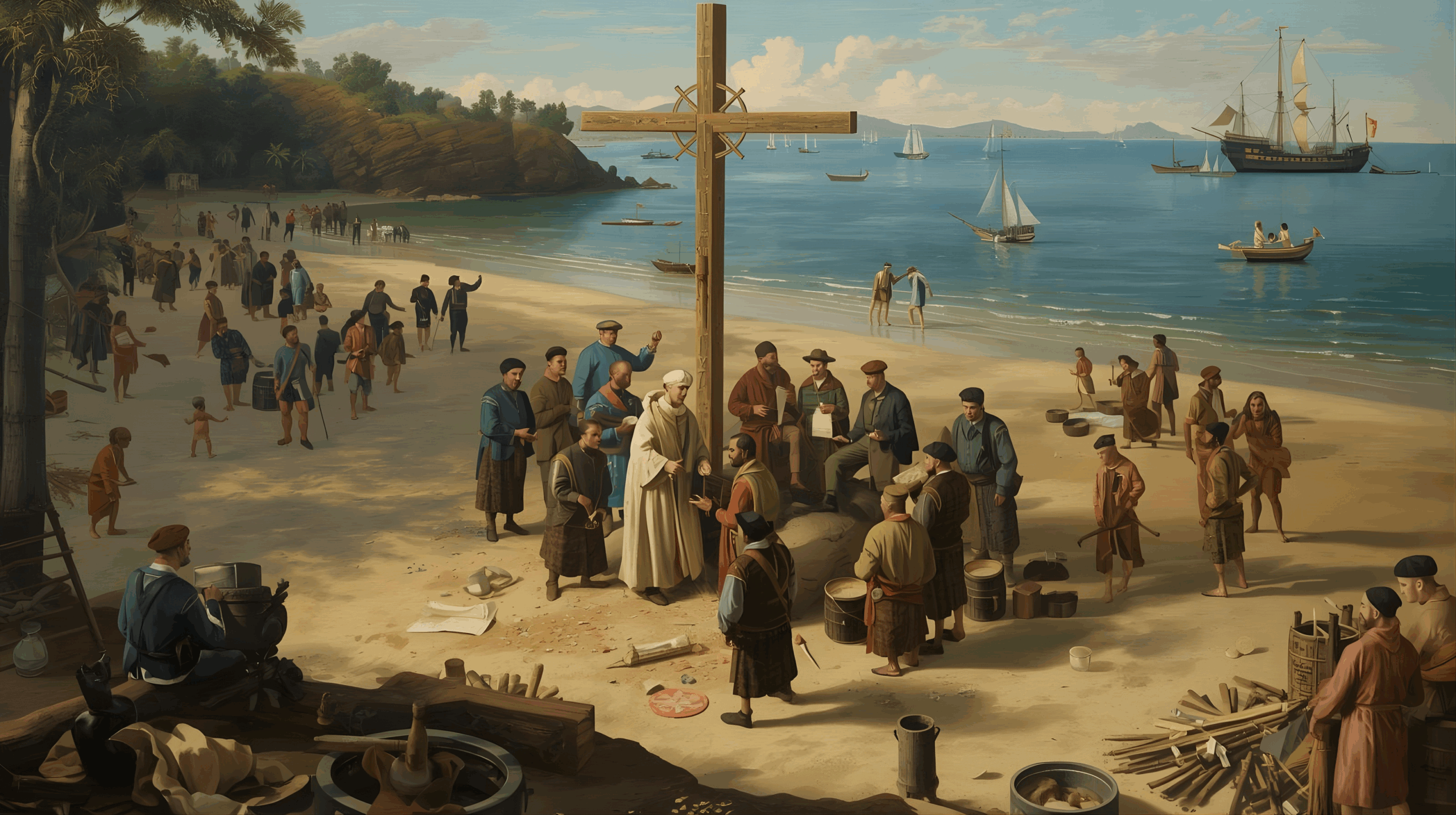
Having established good relations with the indigenous people, some of whom had been welcomed on board the flagship and treated kindly, the captain-major decided that Mass would be celebrated on the islet now called Coroa Vermelha the following day, Easter Sunday.

Friar Henrique de Coimbra recited a prayer and then preached about the discovery of the new land, which was dedicated to the Cross of Christ under whose banner they all came. The indigenous people watched the religious ceremony from the beach in the distance.

After Mass, the commanders held a council on board the flagship and decided to send an emissary to the kingdom with news of the discovery. This would enable the king to organise an expedition to explore the new land more effectively. They also decided that no indigenous people should be taken by force and sent to Portugal.

However, some of the exiles who came with the fleet would remain here to gather information about the land and learn the language of its natives.

Gaspar de Lemos was chosen to command the supply ship that would carry the news.

The other ships spent the following days distributing the goods contained therein. As with the loading of fresh water and firewood, which was carried out next, the natives willingly assisted the sailors.

On 27 April, a large tree was felled and used to make the cross that would mark the Portuguese crown’s possession of the new land, together with the royal arms and insignia. On 1 May, another mass was solemnly celebrated on dry land near the mouth of the Mutari River, again preached by Friar Henrique de Coimbra.

The next day, the fleet set sail for its destination, while the supply ship departed for Portugal. Two exiles and perhaps two ship’s boys, who had fled the ship the night before, remained behind.

O Descobrimento do Brasil — Abril–Maio de 1500 — praia do Porto Seguro ao amanhecer, enseada quase fechada por recife; na areia, celebração da missa presidida por Frei Henrique de Coimbra com padres franciscanos, cavalheiros e marinheiros reunidos em torno de uma cruz recém-cortada de grande madeiro; indígenas observando à distância, curiosos e respeitosos. Em primeiro plano, Nicolau Coelho e Bartolomeu Dias desembarcando, cumprimentando nativos e trocando presentes simples (tecidos, objetos metálicos), enquanto alguns indígenas sobem a bordo da nau-capitânia e são tratados com cordialidade. Ao lado, Pêro Vaz de Caminha escrevendo em seu pergaminho e o feitor Aires Correia e o escrivão arrumando documentos; degredados selecionados conversando com nativos, aprendendo palavras. Cena da elevação da cruz com as armas e a divisa reais — bandeira de Portugal hasteada próxima à cruz; fanfarra contida de marinheiros e gestos cerimoniais. Em plano médio, operação de abastecimento: corte de lenha, enchimento de barris de água, distribuição de mantimentos, indígenas ajudando; ao fundo, a frota ancorada na baía, aparecendo o navio de mantimentos prestes a zarpar (com Gaspar de Lemos no convés) rumo a Portugal.
The Discovery of Brazil — April–May 1500 — Porto Seguro beach at dawn. The cove is almost enclosed by a reef. On the sand, Friar Henrique de Coimbra celebrates Mass, with Franciscan priests, gentlemen and sailors gathered around a newly cut cross made of large wood. Indigenous people watch from a distance, curious and respectful. In the foreground, Nicolau Coelho and Bartolomeu Dias disembark and greet the natives, exchanging simple gifts such as fabrics and metal objects. Some indigenous people board the flagship and receive a cordial welcome. Pêro Vaz de Caminha writes on his parchment beside them while the overseer, Aires Correia, and the clerk arrange documents. Selected exiles converse with the natives, learning their words. A scene of the raising of the cross bearing the royal arms and insignia is depicted, with the flag of Portugal hoisted near the cross, accompanied by a restrained fanfare from the sailors and ceremonial gestures. A medium shot shows the supply operation: cutting wood, filling water barrels and distributing supplies. Indigenous people are helping with this. In the background, the fleet is anchored in the bay and the supply ship is about to set sail for Portugal with Gaspar de Lemos on deck.

4. The letter from Pêro Vaz de Caminha.

The discovery of Brazil was chronicled by a worthy narrator: the scribe Pêro Vaz de Caminha, who, in a letter dated Porto Seguro on the island of Vera Cruz on 1 May 1500, provided a brief account of the voyage and a detailed description of the events that occurred during the nine days that the fleet remained in sight of the new land.

Movimentação da Frota de Pedro Álvares Cabral em Porto Seguro
Movement of Pedro Álvares Cabral’s fleet in Porto Seguro.

He thus provided us with a precious and irreplaceable historical document of unquestionable accuracy. This document serves as a true ‘birth certificate’ or ‘baptismal certificate’ for Brazil, written by an observer with keen powers of observation.

There is no information in its twenty-seven pages of text that could be considered superfluous.

Of all the records, those concerning the indigenous people stand out. They are numerous and detailed, recording even the smallest gestures of the inhabitants of the new land in their interactions with the Europeans they were seeing for the first time, as well as among themselves.

The encounter between civilised and indigenous peoples has always been a curious subject, and Caminha’s letter provides a fascinating account of this. The mutual goodwill, the captain-general’s attentiveness and the sailors’ communicative joy are aspects that nobly distinguish this first encounter between the Portuguese and the indigenous peoples of Brazil.

Above all, the comprehensive description provides a rich source of ethnographic study.

This valuable document combines chorographic details, which allow the landing site of Cabral and his companions to be identified, with useful data for studying regional birdlife and botany.

The incidents that occurred during the fleet’s stay in Porto Seguro, the religious ceremonies held at that time and the attempts to integrate the exiles with the indigenous population were meticulously recorded in a letter written by the clerk of the Calicut trading post.

Caminha’s letter included a prediction about how the new land would be used in the future, either for agriculture or as a port of call for ships sailing to India.

‘However, the best fruit that can be reaped from it seems to me to be the salvation of these people,’ he added, emphasising that ‘this should be the main seed that Your Highness should sow.’

A Carta de Pêro Vaz de Caminha — 1º de maio de 1500 — foco central no escrivão Pêro Vaz de Caminha sentado à mesa rústica na nau-capitânia ou em abrigo simples na praia de Porto Seguro, escrevendo com pena de metal e tinta sobre pergaminho largo; expressão concentrada, traços refinados de um homem culto do início do século XVI, vestes modestas de escrivão, ao lado tinteiro, mapas enrolados, instrumentos de navegação (astrolábio, bússola), relatos e sementes/fragmentos botânicos recolhidos.
The Letter of Pêro Vaz de Caminha, dated 1 May 1500, focuses on the scribe Pêro Vaz de Caminha. He is seated at a rustic table on the flagship or in a simple shelter on the beach at Porto Seguro. He is writing with a metal pen and ink on broad parchment. He has a concentrated expression and the refined features of an educated man from the early 16^(th) century. He is wearing modest scribe’s robes and has an inkwell, rolled-up maps, navigational instruments (such as an astrolabe and a compass), reports, and collected seeds and botanical fragments to hand.

This post is also on: Português English Deutsch Español Français

Hide picture