Attempts to define the meridian of the Treaty of Tordesillas.
Partilha das Terras Descobertas - Demarcação do Meridiano de Tordesilhas
1. The context and structure of the Treaty.
The Treaty of Tordesillas stipulated that the demarcation of the 370 leagues west of Cape Verde would be carried out by pilots, astrologers and sailors from both parties. Within ten months of the treaty’s signing, they would travel to the islands and set sail in two or four caravels to the desired point, which would be marked using the sun or north as a reference point, or by sailing leagues.

2. The interests and delays of monarchies
Although representatives from Portugal and Spain had been appointed for the mission, its departure was postponed, its deadline was changed and extended, and the obligation was eventually forgotten, to the benefit of both crowns.
- First, it was Spain that was interested in the Moluccas and the Philippines.
- Then it was Portugal’s turn, as they were concerned about losing Brazilian territories beyond the proposed line.
The sixty-year union of the Iberian Crowns also prevented direct conflicts over borders.

3. Disagreement over where to start in Cape Verde.
The first discussion concerned which of the islands of Cape Verde would be used as the starting point for counting leagues. The archipelago comprises fourteen main islands, which are distributed between the Barlavento and Sotavento groups.
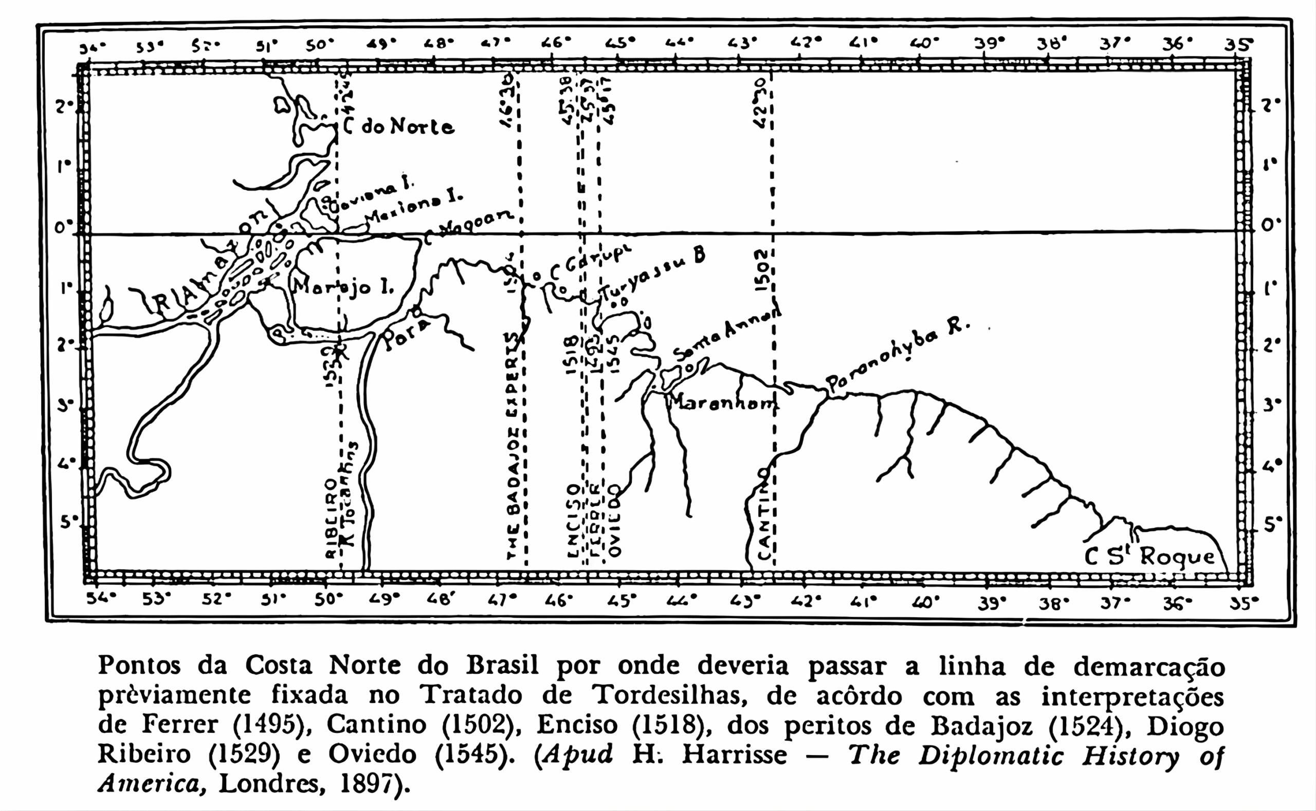
In 1495, Jaime Ferrer proposed leaving Ilha do Fogo, the most central island, while other cosmographers advocated Ilha de Santo Antão, the westernmost island of Barlavento.
The 1502 Cantino map adopted a more easterly line, favouring Portugal over Brazil in the Spice Islands, and projected the line slightly beyond the Parnaíba River delta in Maranhão.
The term ‘Spice Islands’ refers to the Moluccas (also known as the Maluku Islands), an archipelago located in eastern Indonesia.
This guideline was also reproduced by other Portuguese letters.

4. Correction efforts and subsequent positioning.
In Esmeraldo de Situ Orbis (commenced in 1505), Duarte Pacheco Pereira presented a position that more accurately reflected reality by situating Portuguese territory from Marajó to the island of Santa Catarina.
Nevertheless, during the second decade of the sixteenth century, it was argued that the Moluccas belonged to Spain. Navigators such as João Dias de Solís and Fernão de Magalhães supported this idea, but both died before they could complete their missions.
5. Maps and claims relating to the Brazilian coast.
Much of the Brazilian coast was already well-known. Lopo Homem’s 1519 map marks many geographical features from the mouth of the Amazon to the River Plate, with Portuguese flags indicating territorial claims.
In turn, the geographer Enciso drew the Tordesillas line further west, between the Turi-Açu and Gurupi rivers in the state of Maranhão.
6. Negotiations and capitulations concerning the Moluccas.
Magellan’s voyage reignited doubts over who owned the Moluccas.
In 1524, representatives from Portugal and Spain met at the border between Évora and Badajoz, but failed to reach a definitive solution regarding the starting point for the measurement in Cape Verde.
Subsequently, due to Spain’s financial difficulties, Charles V negotiated the Capitulation of Zaragoza (1529) with King John III, ceding any rights to the Moluccas to Spain in exchange for 350,000 gold ducats.
7. New cartographic proposals
In 1529, Diogo Ribeiro moved the demarcation line slightly further east to Marajó Island.
In 1531, Pêro Lopes de Sousa erected a Lusitanian landmark at Esteiro dos Carandins (Lower Paraná), beyond the River Plate. This prompted the Spanish to reinforce their presence in the region, ultimately leading to the establishment of Buenos Aires in 1536.

8. Limits proposed by Pedro Nunes.
In 1537, Pedro Nunes, Portugal’s Chief Cosmographer, drew a 370-league-long boundary line that cut across Brazil near the mouth of the Oiapoque River, continuing through the hinterland beyond São Matias Bay and extending Portuguese claims on the continent to their maximum extent.
9. Stagnation and resurgence of the issue
Following these attempts, no new precise demarcations of the meridian were recorded. It was only known that the measurement fell somewhere between Belém do Pará in the north and Laguna in the south.
The Union of the Crowns postponed the issue for sixty years. Although Spain and Portugal did not define their overseas boundaries when peace was established in 1668, the establishment of the Colony of Sacramento in 1680 reignited the dispute.
The Treaty of Madrid in 1750 annulled the Treaty of Tordesillas. The Agreement of El Pardo in 1761 temporarily reinstated it, but it was only the Treaty of Santo Ildefonso in 1777 that definitively ended the Capitulation of the Partition of the Ocean Sea of 1494.

Publicações Relacionadas
This post is also on:
![]() Português
Português ![]() English
English ![]() Deutsch
Deutsch ![]() Español
Español ![]() Français
Français


