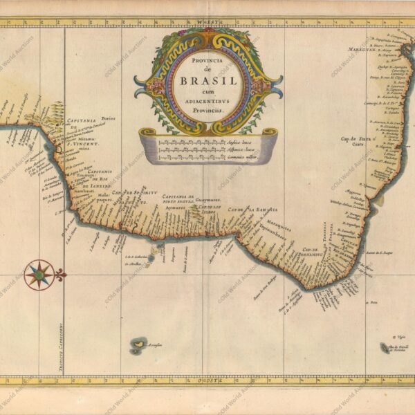
Map of the Captaincy of Paraíba and Rio Grande from 1720 Excellent map of the Brazilian coast, including the captaincies of Paraíba and Rio Grande. The map was drawn after real research by Georg Markgraf, Elias Herckmanns and others and was one of the first maps of Brazil based on […]
Historical Maps of Brazil and the World
The history of Brazil can be told through maps that represent its territorial transformations over the centuries.
Since the beginning of the 16th century, various cartographies have depicted indigenous scenes, fauna, vegetation, and names attributed to the territory — such as Terra de Santa Cruz, Terra Incógnita, Terra dos Papagaios, and Brasil.
- Early 16th century: maps such as those by Giovanni Ruysch (c. 1507) and Waldseemüller’s chart (1507) were among the first to represent the Americas and name it ‘America.’
- 1500 — reports: the Letter/report by Pero Vaz de Caminha is a document of discovery (not a map) and, together with descriptors such as André Thevet, provides ethnographic observations and observations on bartering between Europeans and indigenous peoples.
- First detailed coastlines: maps such as Cantino’s (1502) show the Brazilian coast with greater precision and helped to establish initial place names.
- 16th century — European cartographers: authors such as Gastaldi, Ortelius and Mercator produced maps that recorded territorial disputes and various names; Mercator (1569) introduced the projection that influenced global navigation (not specific to Brazil).
- Foreign presence and barter: representations documenting the French (e.g., Antarctic France), English, and Dutch presence on the Brazilian coast, as well as commercial contact with indigenous peoples, begin to appear.
- Iberian Union (1580–1640): the Philippine administration (Philippine Crown) encouraged the updating of Luso-Brazilian cartography; maps by Portuguese authors, such as João Teixeira Albernaz I, record fortresses, settlements and captaincies.
- 17th century — Portuguese manuscript cartography: noteworthy are the maps by Albernaz II (c. 1666), which detail the coast, São Paulo and the Jesuit missions in the south.
- Dutch cartography (1624–1654): Dutch cartographic production on Pernambuco/Olinda and Recife is significant; some maps from the period (associated with the Maurits period) document occupations and fortifications — check specific titles/attributions according to the source.
- 18th century — French cartography: Guillaume de L’Isle and Jean Baptiste Bourguignon d’Anville produced maps correcting positions and longitudes previously calculated by the Portuguese; De L’Isle’s work influenced negotiations such as the Treaty of Madrid (1750), which generated extensive cartography of the borders.
- 19th century: provincial, hydrological, and border cartographic production grows. Among minor and handwritten works are regional guides and atlases — for example, references to an atlas/manuscript entitled Guia dos Caminhantes (1817) should be verified in primary sources before definitive citation.
- Late 19th century / early 20th century: systematic surveys and military and civil mapping increased territorial accuracy. The publication entitled Carta geographica do Brasil (Engineering Club, 1922) consolidates part of this work — it is recommended to indicate the author/edition when citing.
Significant Historical Maps of Brazil
- Map by Juan de la Cosa — c. 1500: carta-mundi showing the coastline of the Americas, including northeastern Brazil.
- Letter/account by Pero Vaz de Caminha — 1500: account of the arrival and discovery of Brazil (not a map).
- Cantino Map — 1502: first European map to show the Brazilian coast in detail.
- Map by Lopo Homem — c. 1519: Portuguese cartographic map from the early 16th century (associated with Portuguese Atlantic production; avoid direct attribution to the ‘Miller Atlas’ without reference).
- Mercator Map — 1569: introduced the Mercator projection; influential in global cartography (not specific to Brazil).
- Map by João Teixeira Albernaz I — 1640: representations of the captaincies and the Atlantic coast.
- Map by Guillaume Delisle — 1703: detailed map of Brazilian territory widely used in Europe.
- Maps of the Treaty of Madrid — 1750: maps used in the redefinition of Portuguese-Spanish borders.
- Map of the Empire of Brazil — c. 1822: initial representations of the territory after independence.
- Cruls Mission — 1892–1894: survey that informed the choice of the future capital (Brasília).
Historical maps are essential tools for understanding the territorial, political, and economic evolution of Brazil, from colonisation to the consolidation of the Republic.
Map of All Saints Bay 1769 – Historical Maps
Map of the Bay of All Saints, 1769 This map is a boldly engraved graphic of the Bay of Salvador (Bahia) with an inset plan of the fortified city of Salvador. Navigational soundings and shoals are shown in the bay. Numerous plantations and sugar mills are marked with symbols along […]
All Saints Bay Map of 1644 – Historical Map
Map of the Bay of All Saints, 1644 This rare map of Salvador and the Bay of All Saints shows the Dutch attack and capture of the city of Salvador in May 1624. Salvador, then the capital of Brazil, was a strategic port under Portuguese control. The Dutch, determined to […]
Engraving of Cabo Santo Agostinho from 1645 – Historical Engravings
Engraving of Cape St. Augustin from 1645 This beautiful panoramic view shows the Dutch fleet and the fortifications of Cape St. Augustin. Published by Gregorio Letie, this scene was copied from an earlier publication dating from around 1640. It’s interesting to note that the image was inverted during the engraving […]
Engraving of Sirinhaém from 1671
Engraving of Sirinhaém, 1671 Montanus’ work was perhaps the largest illustrated book on the New World produced in the 17th century. It contained more than one hundred beautifully engraved plates, views and maps of North and South America. The plates vividly depicted forts, festivals, occupations, Dutch fleets, battles, religious rites […]
Engraving of Salvador de Bahia from 1770 – Historical Maps
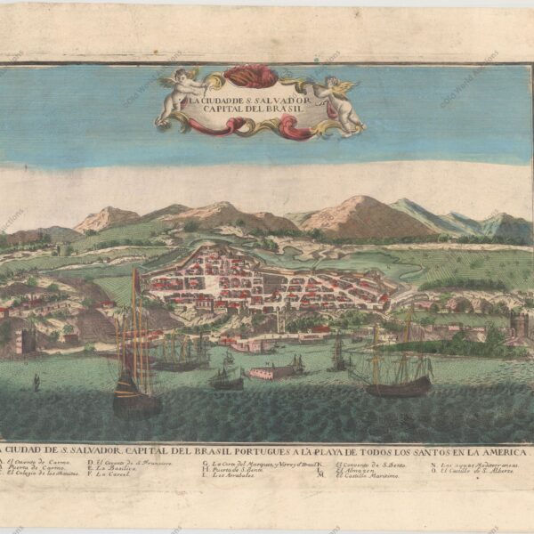
Copper engraving of Salvador de Bahia, 1770 Salvador, the former capital of Brazil, was a strategic port under Portuguese control. This beautiful engraving shows the walled city of Salvador with ships and boats filling the harbour in the foreground. A key of letters at the bottom identifies various locations. This […]
Map of the Brazilian coast from the Paraíba River to Cabo de Santo Agostinho
Map of the Brazilian coast from Rio Paraíba to Cabo de Santo Agostinho, 1683 “Pas-Kaart, van de Zee-Kusten, van, Brazilia, Tusschen, Punto de Lucena en Cabo S. Augustino”, Keulen, Johannes van This rare and classic sea chart covers the Brazilian coast from the river Paraíba to Cape St. Augustino. Augustino. […]
1757 Map of the Western Hemisphere
1757 Map of the Western Hemisphere This beautiful map of the Americas includes the Solomon Islands. In North America, the Pacific Northwest is left open, completely blank and marked Undiscovered Parts. The coastline ends near Alaska with the note The Alleged Strait of Annian. The British colonies are shown east […]
Map of Brazil from 1850 – Historical Map of Brazil
Map of Brazil from 1850 The maps in The Illustrated Atlas were first published in serial form for an audience isolated by the cost and difficulty of travel. All this changed as the 19th century brought rapid and dramatic changes in public awareness of distant places. Tallis’s maps undoubtedly played […]
Map of the East Coast of Brazil, 1647 – Historical Maps
Map of the East Coast of Brazil from 1647 This beautiful map of the Brazilian coast is decorated at the top with a huge garland of native fruits and a jaguar, tapir and capybara. With north to the right, the map covers the coastal region from São Francisco south to […]
Map of Brazil 1554 – Historical Maps of Brazil
Map of Brazil from 1554 This fascinating pictorial map is one of the first regional maps of Brazil available. Illustrated with north to the right, the map is filled with vignettes depicting native life rather than focusing on geographical information. Indians are shown with bows and arrows, axes, llamas and […]
Map of Brazil 1747 – Historical Maps of Brazil
Map of Brazil from 1747 Copper engraved map with good detail along the coast with dozens of place names. The map covers the region between northern Paraguay and north to the mouth of the Amazon. A large inset of St Catherine’s Island fills the empty ocean. In a long note […]
Map of Cabo Santo Agostinho from 1645 – Historical Map of Brazil
Map of Cape St. Augustin from 1645 This beautiful copper engraved map shows the harbour and fortifications of Cabo Santo Agostinho. Fort Nazaré is shown on a hill to the right. Decorated with a compass pointing north at the top right of the map and a title cartouche in stripes. […]
1671 engraving of Fort Orange on the island of Itamaraca
Orange fort on the island of Itamaraca, 1671 “I. Tamaraca”, Montanus, Arnoldus Montanus’ work was perhaps the largest illustrated book on the New World produced in the 17th century. It contained more than one hundred beautifully engraved plates, views and maps of North and South America. The plates vividly depicted […]
Engraving of the Fort of the Three Kings in Natal, 1671
Engraving of the Fort of the Three Kings in Natal, 1671 Montanus’s work was perhaps the largest illustrated book on the New World produced in the 17th century. It contained more than one hundred beautifully engraved plates, views and maps of North and South America. The plates vividly depicted forts, […]
Reis Magos Fort Engraving from 1690 – Engravings Stories
Engraving of the Fort Reis Magos from 1690 – Natal An aerial view of the fort (now Natal) at the mouth of the River Potengi, showing the Dutch invasion and capture of the Portuguese fort in 1633. The harbour is full of ships and armies are shown rushing to defend […]
Engraving of the Bay of Todos os Santos from 1690 – Historical Engraving
Engraving of the Bay of Todos os Santos from 1690 A beautiful copper engraving depicting the Dutch fleet capturing the fort at the entrance to Todos os Santos Bay, in north-eastern Brazil. The scene is very lively, with billowing cannons and small figures rushing into the fray. A close-up of […]
Map of Cabo de Santo Agostinho from 1690
Map of Cape St. Augustin from 1690 This beautiful panoramic view shows the Dutch fleet and the fortifications of Cape St Augustine. The strapwork title cartouche contains a numbered key identifying four locations. – “Afbeeldinge vande Cabo St. Augustin met Haer Forten”, Leti, Gregorio Map of Cabo de Santo Agostinho […]
Map of Paraíba of 1690 – Historical Maps of Brazil
Map of Paraíba from 1690 This panoramic map shows the region of Paraíba and the Portuguese fortifications at the mouth of the Paraíba River. The scene of the Dutch attack on the region is illustrated with the Dutch fleet and the defence of the Portuguese armies. “Afbeeldinghe van Pariba ende […]
Map of Brazil from 1630: Cartography’s Legacy
Map of Brazil from 1630 This beautiful map was a collaboration between Hessel Gerritsz, official cartographer of the Dutch East India Company, and Johannes de Laet, director of the newly formed Dutch West India Company. His maps of South America laid the foundations for many other cartographers. The detail is […]