Explore Picos das Almas, Itobira and Barbado: A trekking paradise in Chapada Diamantina
This guide explores a special itinerary for trekking enthusiasts in the Chapada Diamantina, focusing on the ascent of the three highest peaks in northeastern Brazil: Pico das Almas, Pico do Itobira and Pico do Barbado.

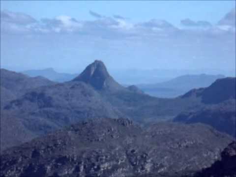
The giants of Chapada Diamantina
- Pico das Almas: 1,958 metres high, the third highest point in the Northeast. Located on the border between the municipalities of Livramento de Nossa Senhora and Rio de Contas.
- Pico do Itobira: 1,970 metres, the second highest point in the northeast.
- Pico do Barbado: 2,033 metres, the highest point in the Northeast of Brazil. It is located between the municipalities of Rio do Pires and Abaíra.
The region around Rio de Contas, a town at the foot of these peaks, is a spectacle in itself.
With a wall over a thousand metres high, the mountain forms a complex of valleys, rock fields, caves, canyons and waterfalls.
Rio de Contas, the oldest town in the Chapada Diamantina, has a rich colonial architectural complex with almost 300 historic buildings listed by IPHAN, including the Mother Church and the São Carlos Theatre.

The fascination of Pico das Almas
In addition to its scenic beauty, Pico das Almas is a treasure trove of biodiversity. In 1974, researchers from Kew Gardens catalogued 1,200 plant species in the region, 100 of which are endemic.
This biological wealth places Pico das Almas in a prominent position in South America, comparable to the Amazon rainforest in terms of biodiversity per square metre.
Crossing the Three Peaks: A challenging route

The complete traverse of the three peaks is an adventure of about 43 kilometres, with a medium to difficult level of difficulty. The route includes
1st day: Rio de Contas – Pico das Almas – Vale do Queiroz
The trail starts at Fazenda Silvana, passing Portal das Almas, an impressive rock formation.
The climb to the summit of Pico das Almas takes about 3 hours and is rewarded with panoramic views of Chapada Sul. The night is spent in the Queiroz Valley, an ecological reserve at an altitude of 1,600 metres.
- Difficulty: Moderate
- Estimated time: 6-8 hours (return)
- Route: Approximately 7 km (return)

2nd day: Queiroz Valley – Itobira Peak
Return to Fazenda Silvana and drive to Caiambola, the start of the trail to Pico do Itobira.
The walk to the summit, at 1,980 metres, takes about 2 hours and 30 minutes and takes you through fields of flowers and breathtaking views. You can spend the night on the summit or at the base.
- Difficulty: Moderate to difficult
- Estimated time: 5-7 hours (return)
- Route: Approximately 9 km (return)


Day 3: Itobira Peak – Guarda Mor Valley
Descent from Pico do Itobira and walk to Lapa da Mutuca, one of the most challenging and beautiful sections of the traverse. Overnight in the Guarda Mor valley.
- Grade of difficulty: Medium to difficult
- Estimated time: 4-6 hours (return)
- Route: Approximately 8km (return)
Day 4: Catolés – Pico do Barbado – Piatã
Climb to Pico do Barbado, passing through Forquilha da Serra, a step between Pedra do Elefante and the summit.
From the summit, at 2,033 metres, the view is breathtaking, taking in the other two peaks, Serra da Tromba and other formations of Chapada Diamantina. Descent to Catolés de Cima and transfer to Piatã.
- Difficulty: Difficult
- Estimated time: 5-7 hours (return)
- Route: Approximately 10 km (return)

The top of the northeast: Pico do Barbado
Located between Rio do Pires and Abaíra, Pico do Barbado can be reached by foot from Catolés de Cima. The climb takes about 2h30. From the top you can see the Picos das Almas and Itobira, the Serra da Tromba and other mountains in the region.
How to get there
Rio de Contas: The city can be reached by road from Salvador, Vitória da Conquista and other cities in Bahia. BR-420 and BA-142 are the main access routes.
Trails: Trails to the peaks usually start from farms or rural communities. It is advisable to hire local guides or use transport services to get to the trailheads.
Maps of the trails


Additional information
- We recommend the use of maps and specialist guides to cross the three peaks.
- It is important to be prepared for changes in temperature and altitude.
- The best time to trek is during the dry season.
This guide provides an overview of the experience of trekking the highest peaks in the Northeast. Remember to consult other sources and plan your adventure carefully to make the most of the beauty of Chapada Diamantina.
Publicações Relacionadas
Rio de Contas: Learn about the history of the city's formation
History of the settlement of Chapada Diamantina
Andaraí which is the second main city of Chapada Diamantina
The municipality of Rio de Contas is today known for its natural beauties
Mining in the Chapada Diamantina History Explained
Relief, Fauna and Flora of Chapada Diamantina
Emerald hunters in the Chapada Diamantina
Main Towns and Villages in the Chapada Diamantina Region
Orchids of the Chapada Diamantina in Bahia
Curiosities of Rio de Contas in Chapada Diamantina
Ecotourism in Morro do Chapéu at 1012m altitude
Chapada Diamantina's architectural style and influences
Igatu: Explore the 19th-Century Stone Houses
Sempre-Viva: Symbol of Preservation in the Chapada Diamantina
Birds Found in Chapada Diamantina: A Guide
Trekking - Most popular trails in Chapada Diamantina
How to get to Cachoeira da Fumaça in Vale do Capão
Discover the diving spots of Chapada Diamantina
This post is also on:
![]() Português
Português ![]() English
English ![]() Deutsch
Deutsch ![]() Español
Español ![]() Français
Français


