Cariri, located in the south of the state of Ceará, is a region rich in cultural heritage, the result of the confluence of different traditions, especially those of the indigenous communities that inhabited the area, such as the Kariris Indians.
Cultural identity
The mixing of different peoples, including indigenous, European and African, combined with Cariri’s relative isolation from Brazil’s major urban centres, has resulted in a unique cultural identity.
The region is famous for its folk dances, typical songs and unique religious and artistic expressions.

International recognition
Cariri is recognised as a “cultural melting pot” that preserves the traditions of its ancestors, as described by the United Nations Educational, Scientific and Cultural Organisation (UNESCO).
This recognition highlights the region’s importance in preserving cultural diversity.
Geological importance
In addition to its cultural wealth, the Cariri region is notable for having one of the largest deposits of fossils from the Lower Cretaceous (dated between 90 and 150 million years ago) in Brazil and the world.
This geological feature led UNESCO to select the cities of Barbalha, Crato, Juazeiro do Norte, Missão Velha, Nova Olinda and Santana do Cariri to form the Araripe Geopark, underlining the area’s importance for human history.

Literary heritage
Cariri is also home to the municipality of Assaré, where the famous poet Patativa do Assaré, an emblematic figure of Brazilian popular literature, was born and lived. His work reflects the culture and experiences of the people of Cariri.

Cultural Itinerary
We have prepared a Route covering six municipalities in the region, promoting tourism that includes cultural, ecological, adventure and religious aspects.
The natural beauty at the foot of the Chapada do Araripe offers breathtaking scenery, known as an “oasis in the middle of the sertão”, while the towns preserve memories of revolutions, traces of coronelismo and popular manifestations steeped in faith.
The challenge of the route
Given the cultural and natural wealth of Cariri, it is a challenge to design an itinerary that covers all these facets.
It’s inevitable that some attractions will be left out. However, with the help of an experienced tour guide, we have prepared a three-day itinerary that promises to be an enriching experience.
The Ministry of Tourism has designed a tour that covers six municipalities in the Cariri Metropolitan Region, allowing visitors to explore the cultural diversity and natural beauty of this unique region.
Cariri, with its mix of history, culture and nature, is an unmissable destination for those who want to understand the essence of Ceará.
3-Day Tourist Itinerary in the Cariri Region

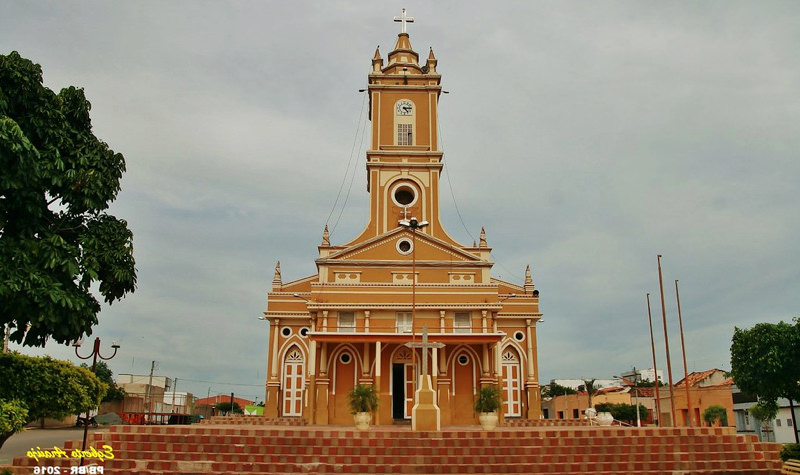
1. FIRST DAY – Missão Velha – Missão Velha Waterfall – Petrified Forest Geosite
In the morning, tourists can visit Missão Velha, half an hour from Juazeiro do Norte. This is where Cariri’s first village was built at the beginning of the 18th century, when Jesuit missionaries gathered at Sítio Cachoeira, which became the city centre.
Roteiros de Fé - Missão Velha - CE18:24
Pontos Turísticos da Região do Cariri CE05:25

Geossítio Floresta Petrificada do Cariri CE01:00

Juazeiro, Barbalha, Crato e Santana do Cariri05:25
Petrified Forest Geosite
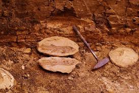
In Missão Velha, the first place to visit is the Petrified Forest Geosite, located in Sítio Olho D’água Comprido, 6 kilometres from the town centre.
This site has fossil trunks that are about 145 million years old, which are invaluable for the study of palaeobotany and geological evolution.

Missão Velha Waterfall
From there, visitors head to the other geosite, the Missão Velha Waterfall, a postcard of the municipality, 11 kilometres from the Petrified Forest. Formed by the Salgado River, the Waterfall is magnificent, with three cascades of approximately 12 metres in height.

In addition to its natural beauty, there are important geological aspects, such as its sedimentary sandstone rock from the Cariri Formation, which is about 420 million years old.
The structure also preserves ichnofossils, which are traces of the vital activity of ancient organisms, in this case aquatic invertebrates.
In addition, the Missão Velha Waterfall is surrounded by various legends and stories. Some researchers believe the site was used as a ceremonial site by indigenous peoples.
Tourists also have access to a 1.9km-long, medium-difficulty trail that leads to a stone house at Sítio Emboscada. It is thought that this house, built in the 18th century, was one of the first to be built in Cariri.
Historic centre
Before heading on to the next town, visitors can stroll through the Centre and see some well-preserved old houses. After lunch and a rest, the next stop is Barbalha, 22 kilometres from Missão Velha.
Barbalha
Known as the Land of the Green Cane, Barbalha is famous for the largest festival in honour of Saint Anthony in the world, the Pau da Bandeira.
In addition to the ruins of the sugar mills that made the sugar economy important in Cariri, the Historic Centre has the best preserved mansions in the region.
Another important aspect is the natural wealth.
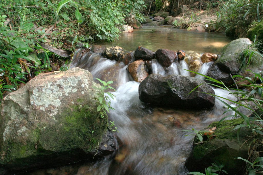
The municipality has several trails and spas at the foot of the Chapada do Araripe. Within the territory of the Araripe Geopark, Barbalha also has its own geosite, the Riacho do Meio, located 7.6 kilometres from the town centre.
This site, which is a Conservation Unit, offers trails, springs and is one of the refuges for the soldadinho-do-araripe, a bird endemic to the region.
2. SECOND DAY – Horto Hill – Batateiras Geosite
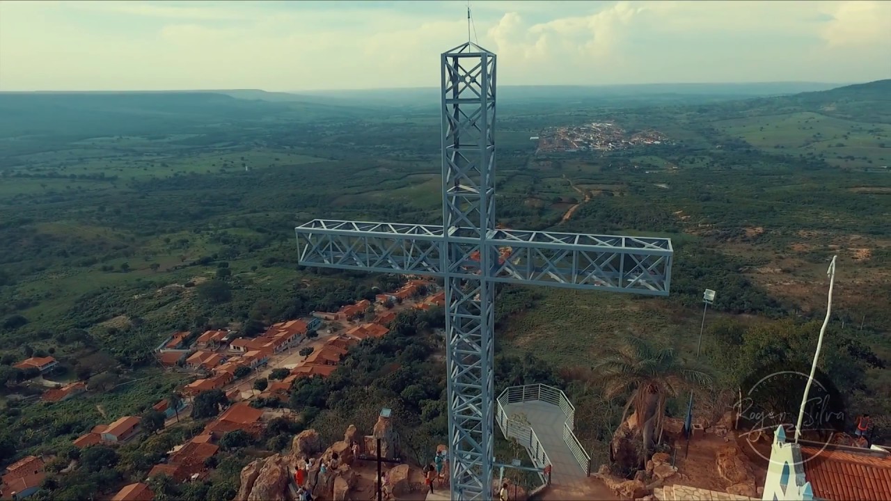
Early in the morning, visitors can visit Horto Hill, in Juazeiro do Norte, where the statue of Padre Cícero is located.
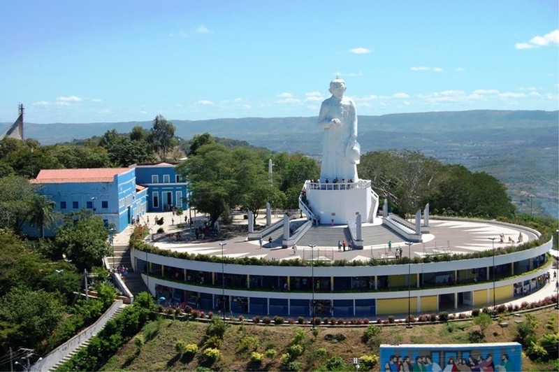
Geossítio Colina do Horto - Padre Cícero
The town’s postcard also houses the Living Museum dedicated to the town’s founder, which includes personal items belonging to the parish priest and numerous ex-votos, as well as wooden sculptures of those who paid a promise.
Memories of the 1914 war
A few metres away is the Wall of the 1914 War, where the pilgrims supported by the priest defeated the state forces and deposed the governor Franco Rabelo. Still in the Horto, there is a path that leads to the legendary Holy Sepulchre, which has a breathtaking view.
Crato: the princess of Cariri
In the afternoon, Crato is the place to stop. As well as countless trails, the Princess of Cariri has several spas at the foot of the Chapada do Araripe. “If you want, you can walk all day,” jokes the guide.
Batateiras Geosite
An ideal place for this is the Batateiras Geosite, located in the Sítio Fundão State Park.
Covering some 93 hectares, the reserve contains the ruins of an old mill still powered by animal traction. It also has a rare single-storey house made entirely of rammed earth and is crossed by the Batateiras River.
Geossítio Batateiras
Lameiro Waterfall
Another place that attracts bathers is the Lameiro Waterfall, also formed by the Batateiras River. With a waterfall eight metres high and an area 2.5 metres deep, it is ideal for those who want to relax. Open to the public and close to the town centre, the waterfall attracts many people at weekends.
3. THIRD DAY – Ponte de Pedra Geosite – Casa Grande Foundation – Kariri Stone – Pterosaur Park – Pontal da Santa Cruz
We recommend visiting two municipalities in the so-called “Cariri Oeste“.
The first is Nova Olinda.
Ponte de Pedra Geosite

Just before you reach the town, on the CE-292, you will find the Ponte de Pedra geosite.
With a beautiful view over the valley, it is represented by a natural rock formation that resembles a bridge. The structure is thought to be 96 million years old.
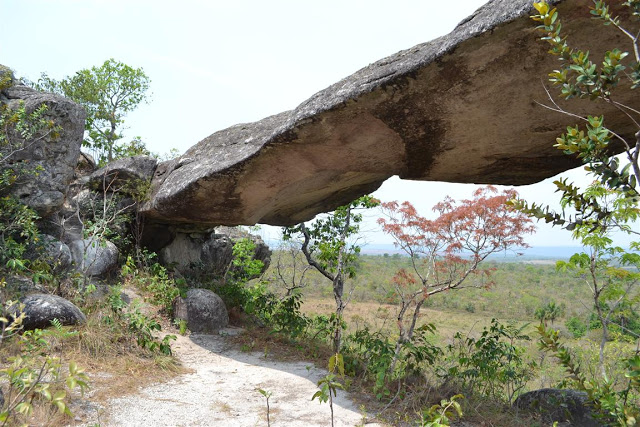
Geossítio Ponte de Pedra no Ceará
Casa Grande Foundation
In the centre of Nova Olinda is the Casa Grande Foundation – Kariri Man Memorial, which acts as an archaeological centre for the region. In addition to its fantastic work with the town’s children, the building houses a number of indigenous artefacts.
Next door is the Leather Museum of craftsman Espedito Seleiro, next to his studio. His pieces, such as handbags, slippers and wallets, are in demand in Brazil and around the world.

Santana do Cariri
The last stop is Santana do Cariri, where there are three geosites: Pedra Kariri, Pontal da Santa Cruz and Parque dos Pterossauros.
Geossítio Parque dos Pterossauros no Cariri
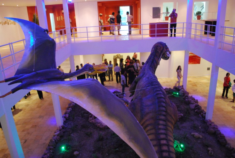
The town is also home to the Plácido Cidade Nuvens Palaeontology Museum, which has an important collection of fossils and replicas of dinosaurs that lived in Cariri millions of years ago.

Geosite Pedra Kariri
Santana do Cariri is home to the Pedra Kariri geosite.
At the Pontal da Santa Cruz, which offers an excellent lunch, tourists can enjoy a panoramic view of Cariri and watch the sunset, one of the most beautiful in Ceará.
Trail to the Buritis Valley
If you want to go a little further, there’s the 5.6km trail to Vale dos Buritis or Vale dos Azedos.
There you’ll find a viewpoint over the valley of Santana do Cariri and, down the slope, an ideal spot for a swim.
Pterosaur Park
The Pterosaur Park in Santana do Cariri contains many fossils.
Geossítio Pontal da Santa Cruz – Geopark Araripe
Final thoughts
If you want to extend your stay, you can visit other municipalities such as Altaneira, which offers hiking trails and even abseiling; Assaré, the land of Patativa do Assaré, which breathes culture and has a monument to the poet; Milagres and Mauriti, which have important archaeological sites; and Porteiras and Jardim, known for their viewpoints and waterfalls.
Ceará and Northeast Guide
Publicações Relacionadas
Serra de Ibiapaba: A natural paradise for adventure and ecotourism
Guaramiranga: The Switzerland of Ceará
Religious Tourism in Juazeiro do Norte and in Northeast Brazil
Cariri in Ceará: An Ecological and Cultural Tourism Destination
Baturité Massif: A Scenic Destination in Ceará
Ubajara National Park: Adventure Awaits in Ceará
This post is also on:
![]() Português
Português ![]() English
English ![]() Deutsch
Deutsch ![]() Español
Español ![]() Français
Français


