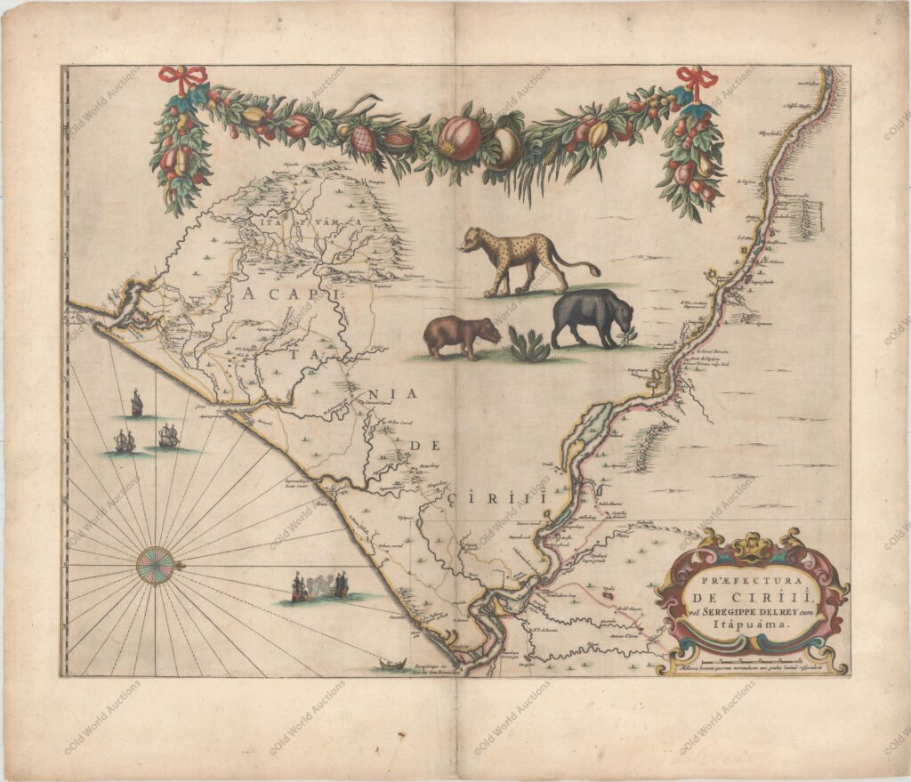
Map of the East Coast of Brazil from 1647
This beautiful map of the Brazilian coast is decorated at the top with a huge garland of native fruits and a jaguar, tapir and capybara. With north to the right, the map covers the coastal region from São Francisco south to the mouth of the Vaza-Barris River.
The map follows the rivers inland, with place names and topographical details along their banks.
There is a naval skirmish, three Dutch ships and a canoe on the Atlantic coast.
Based on real surveys by Georg Marcgraf, Elias Herckmanns and others, it was one of the first maps of Brazil based on non-Portuguese data.
Blaeu first published this and its supplementary maps in 1647 for Gaspar Barleus’ Rerum per octennium in Brasília.
They were also compiled into a large wall map, Brasília qua parte paret Belgis.
The maps then appeared in the Atlas Maior of 1662. “Praefectura de Ciriii, vel Seregirppe Delrey cum Itapuama”, Blaeu, Johannes
Map of the East Coast of Brazil from 1647 – Historical Maps of Brazil
Publicações Relacionadas
1587 Map of the Western Hemisphere - Historical Map
Map of Salvador de Bahia from 1748
Map of the Captaincy of Pernambuco and Ceará from 1680
Map of Rio de Janeiro, 1794 - Historical Map
Map of Panama 1699 - Historical Map
1719 Map of the Western Hemisphere - Historical Map
Map of the Brazilian Coast from 1678 - Historical Map of Brazil
1694 Map of South America - Historical Map
Painting of the Three Kings Fort in Natal from 1647
1575 Map of Europe - Historical Map
1679 Map of Recife - Historical Map
1744 Map of the Western Hemisphere - Historical Map
1638 Map of South America - Historical Map
1643 Map of the Western Hemisphere - Historical Map
Map of the Brazilian coast from the Paraíba River to Cabo de Santo Agostinho
Engraving of the town of Olinda in 1633 - Historical Engraving
Map of Rio de Janeiro, 1840 - Historical Map
Map of South America and the Caribbean 1596 - Historical Map
This post is also on:
![]() Português
Português ![]() English
English ![]() Deutsch
Deutsch ![]() Español
Español ![]() Français
Français


