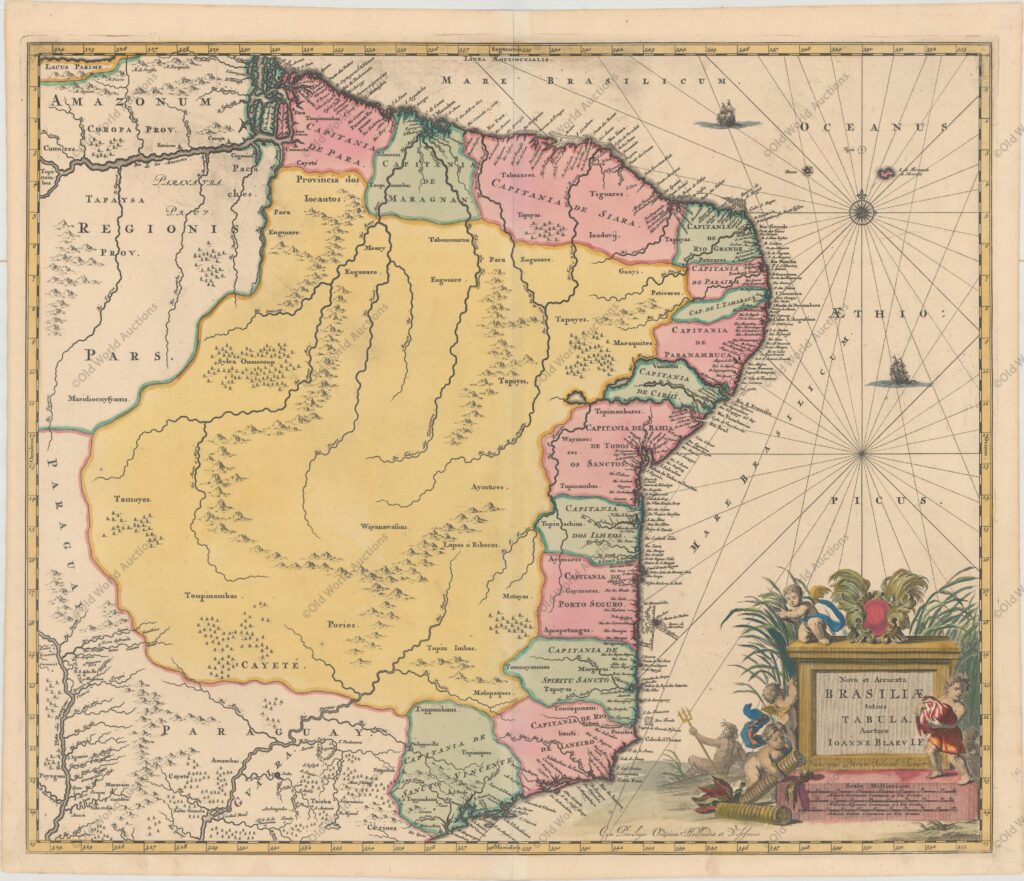
“Nova et Accurata Brasiliae Totius Tabula, Auctore Ioanne Blaeu I.F.”, Blaeu/Schenk
This scarce map is Johannes Blaeu’s third map of Brazil. It includes the captaincies along the coast and is a significant improvement on Blaeu’s previous maps of Brazil. The beautiful cartouche is surrounded by cherubs and a river god. This map, drawn by Joannes de Broen and engraved by Abraham Wolfgang, was completed just before the great fire that destroyed the printing house and was therefore only included in one edition of Blaeu’s atlases. In 1694 Pieter Schenk acquired several of Blaeu’s copper plates, including this one.
Map of Brazil 1730 – Historical Map
“Nova et Accurata Brasiliae Totius Tabula, Auctore Ioanne Blaeu I.F.”, Blaeu/Schenk
This rare map is Johannes Blaeu’s third map of Brazil.
The map includes the hereditary captaincies along the coast and is a significant improvement on Blaeu’s previous maps of Brazil.
The beautiful cartouche is surrounded by cherubs and a river god.
This map, drawn by Joannes de Broen and engraved by Abraham Wolfgang, was completed just before the great fire that destroyed the printing house and was therefore only included in one edition of Blaeu’s atlases.
In 1694 Pieter Schenk acquired several of Blaeu’s copper plates, including this one.
Publicações Relacionadas
1609 Map of the Western Hemisphere - Historical Map
Map of South America and Brazil 1624 - Historical Map
1660 Map of the Western Hemisphere - Historical Map
Map of Africa from 1570
Map of the Gulf of Mexico and the Caribbean, 1681
Map of Brazil 1698 - Historical Map
Map of the Gulf of Mexico and the Caribbean, 1594
Engraving of Cabo Santo Agostinho from 1645 - Historical Engravings
Engraving of Salvador de Bahia from 1671
Map of the Captaincy of Pernambuco from 1698
Map of Rio de Janeiro, 1794 - Historical Map
Map of South America and the Caribbean 1596 - Historical Map
Engraving of the Fort of the Three Kings in Natal, 1671
Map of Paraíba from 1662
1628 Map of the Western Hemisphere - Historical Map
Map of Brazil from 1850 - Historical Map of Brazil
Map of Rio de Janeiro of 1810 - Historical Map
Map of Olinda in Pernambuco from 1640 - Historical Map
This post is also on:
Português
English
Deutsch
Español
Français


