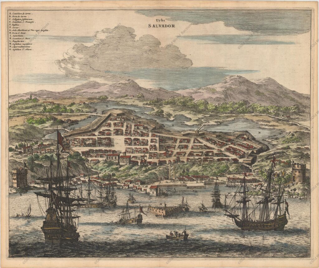
Engraving of Salvador de Bahia from 1671 – De Nieuwe en Onbekende Weereld
“Urbs Salvador”, Montanus, Arnoldus
Montanus’ work was perhaps the greatest illustrated book on the New World produced in the seventeenth century. It contained over one hundred beautifully engraved plates, views, and maps of North and South America.
The plates vividly depict forts, festivals, occupations, Dutch fleets, battles, religious rites, and customs of the native inhabitants.
This important work was translated into German by Olivier Dapper, and into English by John Ogilby. Several of the plates were later acquired by Pierre Vander Aa.
Fine copper engraving of the walled city of Salvador with ships and boats filling the harbor in the foreground. A lettered key at top left identifies numerous locations.
Engraving of Salvador de Bahia from 1671
Publicações Relacionadas
Map of the Province of Paraíba from 1698
1694 Map of South America - Historical Map
1832 Map of Brazil - Historical Map
Map of Brazil from 1630
Maritime chart of the east coast of Brazil Ilha Grande and Sapetiba Bay 1884
Map of Brazil 1554 - Historical Maps of Brazil
Map of Rio de Janeiro, 1840 - Historical Map
1757 Map of the Western Hemisphere
Engraving of the town of Olinda in 1633 - Historical Engraving
1659 Map of the Western Hemisphere - Historical Map
1660 Map of the Western Hemisphere - Historical Map
1730 Map of the Western Hemisphere - Historical Map
Map of Brazil 1698 - Historical Maps of Brazil
1579 Map of the Western Hemisphere - Historical Map
Map of Southern South America, 1668 - Historical Map
Engraving of the Baia de Todos os Santos from 1671 - Brazil
Map of Brazil divided into fourteen hereditary captainships from 1657 onwards
Map of Recife of 1764 - Historical Map
This post is also on:
![]() Português
Português ![]() English
English ![]() Deutsch
Deutsch ![]() Español
Español ![]() Français
Français


