Discover the 12 most important historic cities in the Northeast of Brazil, built during the colonial period and still preserving a large part of their houses.

The history of Brazil
The history of Brazil is rich, extensive and full of contradictions. Developing a narrative that covers the details of the conquest and colonisation of Brazilian territory is no easy task.
What is difficult for historians can be easy for travellers: strolling through the cobbled streets and well-preserved houses of some of the historic towns, it’s natural to feel transported back to the colonial era.
It’s normal to realise that time has simply stopped there, and it’s easier to understand all the historical implications that caused these small towns to rise (usually because of interest in the exploitation of minerals such as gold and diamonds) and to stagnate in time (with the end of the exploitation of these natural resources).
Below is a selection of historic Brazilian cities that still hold the only treasure left: history. Perfect for those who don’t want to miss out on the cultural routes without giving up a lot of charm.
Historic Towns in the Northeast of Brazil
- Olinda – Pernambuco
- Penedo – Alagoas
- Salvador – Bahia
- Cachoeira – Bahia
- Mucugê – Bahia
- Rio de Contas – Bahia
- Porto Seguro – Bahia
- Valença – Bahia
- São Cristóvão – Sergipe
- Laranjeiras – Sergipe
- São Luís – Maranhão
- Alcântara – Maranhão
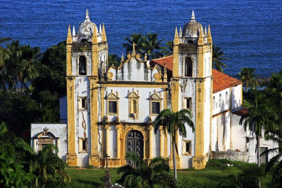
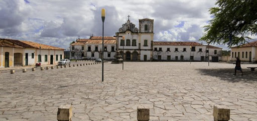
1. Olinda in Pernambuco

Walking through its streets, visitors come across beautiful antique buildings – restored after the Dutch invasion in the 18th century and open to visitors.
Olinda, the former capital of Pernambuco, attracts tourists from all over the world to its history-filled hillsides and blue sea. A stroll through the streets of the city, founded by Duarte Coelho, is a plunge into the history of colonial Brazil.
History of Olinda
Founded in 1535, Olinda became a city in 1537 and was the capital of the Captaincy of Pernambuco until 1654. The city prospered from the extraction of Brazilwood and the cultivation of sugar cane and became one of the most important commercial centres in the colony.

Religious influence
Known as Little Lisbon for the wealth and luxury of its buildings, Olinda’s urban layout is strongly influenced by the religious orders: Carmelites, Jesuits, Franciscans and Benedictines, who catechised the Caetés Indians and allowed the definitive occupation of the land.
The Dutch invasion
The Dutch invasion in 1630 changed the prosperous history of Olinda.
To build houses in Recife, the invaders looted and burned the then capital of Pernambuco, and it was only after their expulsion in 1654 that Olinda began to be rebuilt.
After the Dutch left, the city did not regain its former prosperity and Recife became the economic centre when it was chosen as the capital of Pernambuco in 1827.
Growth in the 19th century
In the 19th century, Olinda began to grow again. Attracted by the therapeutic qualities of the sea baths and the easy access to the capital by train, visitors populated the waterfront with holiday and residential buildings.
Historic centre
One third of the city of Olinda is protected by the Historical Heritage. The area known as Cidade Alta is home to the historic centre of the richest city in colonial Brazil, and you can see the main sights by strolling along its colourful hillsides.
Main Tourist Attractions
The Convent of São Francisco, built in the 16th century, is an excellent starting point for a tour of Olinda’s historic centre. Located at 280 Rua de São Francisco, the convent has a series of Portuguese tile panels and 18th century paintings on its carved wooden ceiling.
Next to the convent, on Rua Bispo Coutinho, you’ll find the Alto da Sé, where you can visit the Mercado de Artesanato da Sé, which is home to craft fairs and the famous tapioqueiras from Olindense.
As well as shopping, visitors can enjoy the exuberant beauty of the Metropolitan Cathedral of St. Saviour of the World or the Sé de Olinda, which was restored in the 1970s, restoring its Renaissance and Baroque architecture.
In the Cathedral Square is the Caixa D’água Viewpoint, which has a panoramic elevator that offers a breathtaking 360º view of Olinda.
The former Palace of the Bishops of Olinda houses the Museum of Sacred Art, which has seven exhibition rooms and a rich collection of religious objects and paintings. The museum is located at Rua Bispo Coutinho, 726.
Still on the same street, the Casa dos Bonecos Gigantes de Olinda is worth a visit.
Continuing along Ladeira da Misericórdia, the Misericórdia Church is a must if you want to appreciate the beautiful Portuguese Baroque and Renaissance architecture.
After passing through the Quatro Cantos, an intersection of the Prudente de Morais, São Bento and Ladeira da Misericórdia streets, and admiring the old houses that form the heart of the Olinda Carnival, the next stop is the Museu do Mamulengo, located at 344 Rua de São Bento. Founded by the puppeteer Fernando Augusto Gonçalves, this is the first Mamulengo Museum in Latin America and houses a collection of over a thousand puppets.
Other places to visit are the Olinda Regional Museum and the Ribeira Market.
Located on the Rua de São Bento, the Ribeira Market has a brick floor characteristic of colonial architecture and houses galleries of handicrafts, carvings, engravings and paintings.
Take a stroll down the street and visit the Convent of São Bento, which has a magnificent gilded main altar and Baroque architecture.
Finally, be sure to explore Olinda’s Historic Centre. Head to the Praça do Carmo and visit the Carmo de Olinda Church.
Built in the 16th century, this church marks the arrival of the Carmelite Order in the city and is decorated in the Baroque style.
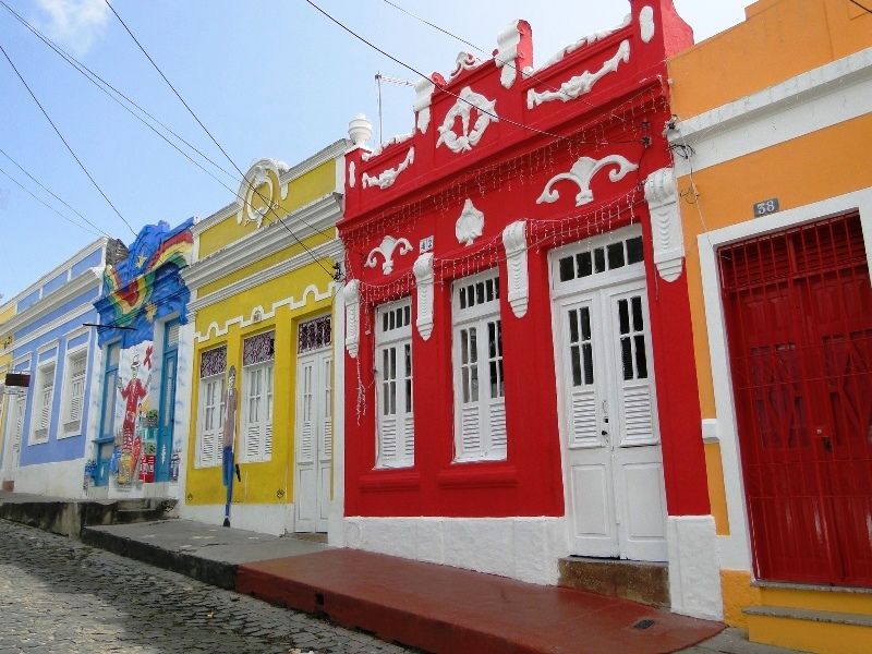
2. Penedo in Alagoas

The buildings of Penedo, which served as a solid base for the first settlement, still in the Captaincy of Pernambuco, are the same unshakeable supports that have withstood almost five centuries of magic and enchantment.
Stories of the Caetés, Portuguese, French, Dutch, Malese, Franciscans, fishermen, poets, painters, sculptors… Penedo, this fantastic city, has a unique history and enchants all who visit it.
Centro Histórico de Penedo em Alagoas08:06
História de Penedo em Alagoas04:57
Cidade Histórica de Penedo AL - Reportagem03:27
Discovery and exploration
It all started with the discovery of Brazil in 1500.
In 1501, Américo Vespúcio discovered the mouth of the São Francisco River, home of the Caetés, a river as big as the sea, the river of the sea, the Old Chico… Gateway to the interior, vehicle of civilisation and culture for our people.
As early as 1502, Europe had heard of the São Francisco River through the Geographical Map of Alberto Cantino, which aroused interest in its gold and silver mines.
The birth of Penedo
In 1534, Duarte Coelho Pereira, the first grantor of the Captaincy of Pernambuco, went down the coast, entered the estuary and found a small settlement seven leagues away, which was not officially recognised until 1560 by the second grantor, Duarte Coelho Pereira de Albuquerque: Penedo do São Francisco.
Elevation to town
On 12 April 1636, it was elevated to the category of City, with the name of Vila do Penedo do São Francisco, and received the title of Mui Nobre e Sempre Loyal (Very Noble and Always Loyal).
This status was achieved because it was a polarising centre of the highest quality human material and because of the refinement of its European-style culture, as well as its socio-economic status.
Dutch invasion
In 1637, Maurício de Nassau invaded Penedo and we spent 10 years under Dutch rule.
The city was renamed Mauritius. But it wasn’t long before a revolutionary movement arose in Penedo to wrest the land from the invaders.
The revolutionary movement was called OPENEDA.
The battle of Penedo
On 19 September 1645, Valentim da Rocha Pita, the great hero of Penedo, led the final battle at Alto do Monte Alegre, now known as Praça Clementino do Monte. A Byzantine-style stone cross was erected there to commemorate the great event.
Development and illustrious visitors
In 1660, the Franciscans arrived in Penedo and built the Convent and Church of Santa Maria dos Anjos, with schools of French, Latin and Philosophy.
On 18 April 1842, Penedo became a town. Due to its importance, Penedo received illustrious visitors. On 14 October 1859, the city of Penedo became the seat of the Imperial Government with the visit of His August Majesty Don Pedro Segundo, Emperor of Brazil.
In August 1889, His Highness Prince Gastão de Orleans e Bragança, Count D’Eu, arrived in the city of Penedo and was given a special audience by the director of the Montepio dos Artistas, an organisation that received a donation of one hundred thousand réis and awarded the Prince the title of Sponsor.
Economic importance
Penedo is notable for the fact that Imperial Decree Number 3.749 of 7 December 1866 opened the navigation of the Lower São Francisco to merchant ships of all nations as far as the port of Penedo.
The following year, Decree No. 3.920 of 31 July 1867 created the Customs House of Penedo.
Creation of institutions
On 8 March 1841, the Penedo Revenue Office was created, which became a consulate on 27 May 1847.
The Provincial Resolution number 781 of 29 May 1878 restored the Consulate of Penedo.
The Provincial Resolution number 838 of 7 June 1880 created the Practical Schools in Penedo, with the aim of training candidates for the Public Magisterium.
Cultural heritage
On 3 February 1760, Colonel João Pereira Alves founded the Santa Casa de Misericórdia de Penedo.
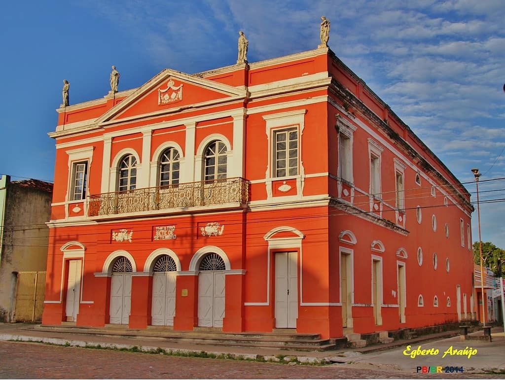
And in 1884, the construction of the Theatro 7 de Setembro was completed. Penedo, city of townhouses, showcase of Alagoas history, cradle of Alagoas civilisation, Mui Nobre e Sempre Loyal cidade do Penedo, Patrimônio Histórico Nacional.
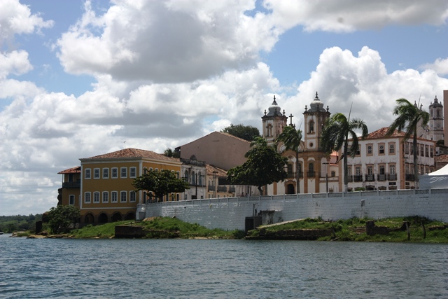
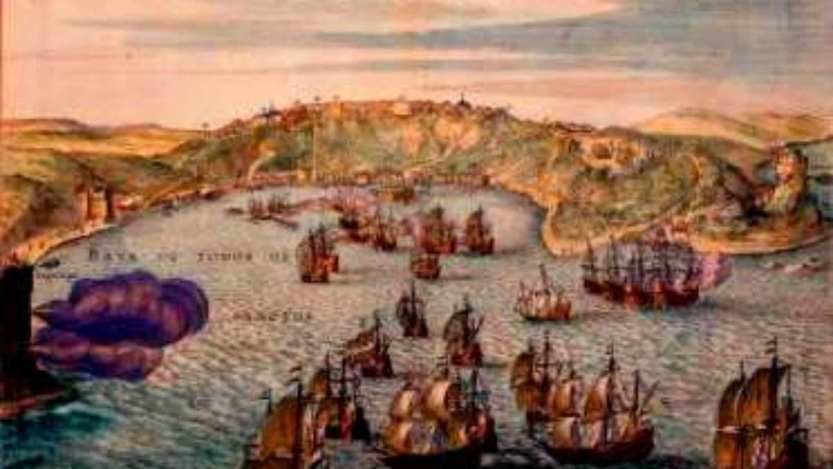
3. Salvador de Bahia

Of course, Brazil’s first capital couldn’t be left out of this list. Salvador was the country’s great political and financial centre between 1549 and 1763 – it was there that the mixture of peoples, cultures, religions and races that is Brazilian society began.
Slave Market
In 1558, America’s first slave market was established in the city to sell recently arrived blacks from Africa to sugar cane mill owners.
Today, the city’s Historic Centre preserves the Renaissance buildings and two-storey mansions typical of wealthy towns.
First inhabitants
The region where Salvador is located was inhabited by the Tupinambás when, in 1501, Gonçalo Coelho, commander of the first exploring expedition, traded with the Indians and set the Portuguese standard of possession at the site of the present Barra Lighthouse, at the entrance to the bay. It was 1 November, All Saints’ Day.
The place became known as Ponta do Padrão, at the entrance to Todos os Santos Bay.
Shipwreck and colonisation
Around 1509 a ship, probably French, was wrecked off the coast of Bahia. One of the survivors, the Portuguese Diogo Álvares Correa (Caramuru), settled on the site of the future Salvador. With the integration of the Europeans, the first settlement appeared.
Captaincy of Bahia
In 1534, the captaincy of Bahia de Todos os Santos was given to Francisco Pereira Coutinho, who settled in the same village as Caramuru.
By the middle of the 16th century, Brazil was seen as a land of promise.
In 1548, after the death of Pereira Coutinho, his captaincy was acquired by the Portuguese Crown so that a large and strong settlement could be established there in accordance with the guidelines of Dom João III’s Regiment.
História da primeira capital do Brasil, Salvador da Bahia
Foundation of Salvador
The process of effective colonisation of Brazil began in 1549 with the founding of its first capital, the City of Salvador.
Its founder, the first Governor General, Thomé de Sousa, landed at what is now Porto da Barra on 29 March and began building the fortified city that would become the administrative centre of Brazil.
The urban layout of the citadel was designed by the master stonemason Luís Dias with a clear concern for defence, surrounded by a palisade.

Buildings and churches
The first buildings were made of mud and straw. By 1549, Salvador had at least five churches: Graça, Vitória, Escada, Conceição da Praia and Ajuda. Only the latter was located within the city, inside the citadel, and in 1552 it became Brazil’s first Cathedral.
Role in the colonial economy
From the 16th to the 18th centuries, Salvador was one of the main links between Portugal, southern Africa and the coast of Asia.
It was the capital of the state of Brazil until 1763, the ecclesiastical capital of Lusitanian America until 1891, and the legal capital of its northern part until 1808. Until the early 19th century it was the largest city in Brazil and the second largest in the entire Lusitanian Empire, after Lisbon. It was the busiest port in the country until the 1870s.
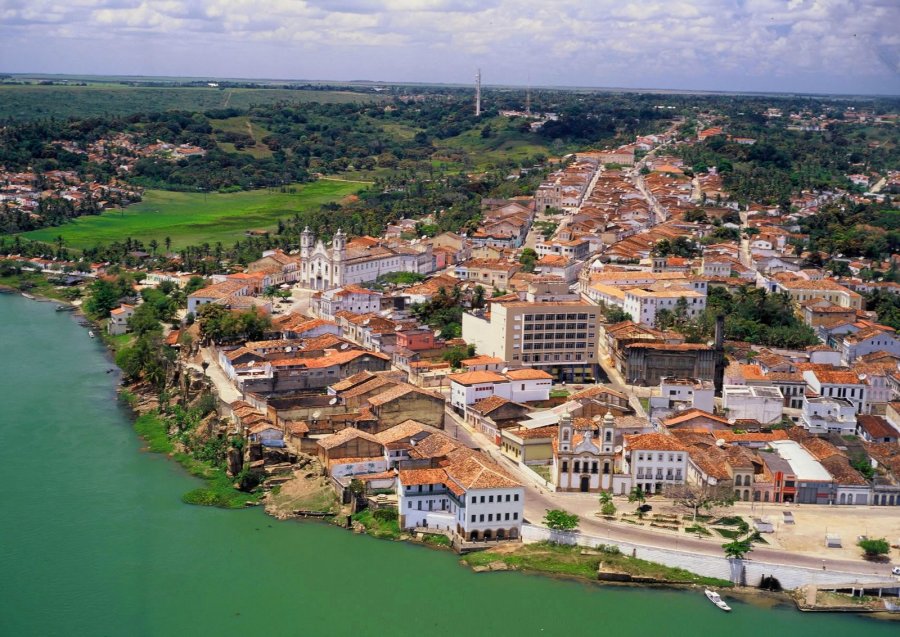
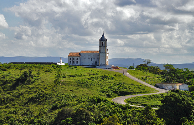
4. Waterfall in Bahia

Located about 110 kilometres from the capital, Salvador, this charming town in the Recôncavo Baiano is striving to make its historical heritage one of the best preserved in the country.
Here you’ll find the largest Baroque architectural complex in the country, with facades, buildings and houses that take you back in time. History tells us that the city was the site of the first events that would lead to Brazil’s independence.
História de Cachoeira na Bahia
Ancient history
Cachoeira was one of the first civilised settlements in Bahia. Some claim that its history dates back to the 16th century. Perhaps because of this, the dates that mark its development are not without controversy.
There are even those who believe that its origins lie in the years 1595-1606, when the chapel of Nossa Senhora da Ajuda was founded on the initiative of Captain Álvaro Rodrigues, who left his descendants the task of preserving it.
Occupation and conflicts
What is certain, however, is that when Rodrigues Adôrno led an expedition in 1654 to put an end to the native incursions along the banks of the Paraguassu, the river valley was already inhabited by some civilised people in the part closest to the coast.
After the savages had been defeated, the leader of the group stayed in the area, where he rebuilt the chapel of Ajuda and made his home.
Parish and town
Due to the great development of the settlement, the Parish of Nossa Senhora do Rosário da Cachoeira was created in 1696, according to some sources. Two years later, the settlement was elevated to the category of town, with the name of Nossa Senhora do Rosário do Porto de Cachoeira.
By this time, the city was already “the largest in area, known as the centre par excellence of our first experiments in land cultivation and the expansion of our trade”.
Commercial importance
During the Sabinada, in 1837-1838, it was the seat of legal government. Cachoeira’s importance can also be measured by the transport routes that connected it to the main economic centres of the time.
Almost all the trade of the hinterland of Minas Gerais and several other parts of the province converged at the port, including the Alto São Francisco area, which at that time was connected to the city by three roads: the Muritiba road, which went via the Port of São Félix to Minas Gerais and Goiás, among other places; the Belém road, which connected it with the southern part of the province; and the Belém road, which connected it with the north of the province, and the Capoeirassu road, which led to the Estrada Real do Gado, where the cattle from Piauí were driven.
Industrial centre
Cachoeira, however, combined its status as a major trading emporium with that of a bustling industrial centre: It produced tobacco, some of which was exported to Africa, where mangotes – short and thick coils of properly prepared rope tobacco – were used as currency to buy slaves.
During the independence struggles, it was one of the main rebel strongholds in Bahia. On 25 June 1822, the Chamber, the troops and the people proclaimed Prince Pedro Regent and Perpetual Defender of Brazil.
Provisional government
Shortly afterwards, a committee of defence was appointed, including Antônio Teixeira de Freitas Barbosa and André Rebouças.
A provisional government was then set up, made up of representatives from all the allied cities, which led the military movement against the capital, which was occupied by Portuguese troops under the command of General Madeira.
For the actions of the people of Cachoeir during these battles, the town was awarded the title of Hero. In 1837 the town became a city.
Economic changes
With the construction of the Railways, the Royal Roads ceased to be the preferred route for transport, and as a result Cachoeira lost much of its economic importance; unused, these roads fell into disuse in several stretches.
Today, part of the municipality’s economy is based on sugar cane, tobacco and cassava.
According to the administrative division in force on 30 June 1956, the municipality is made up of 3 districts: Cachoeira, Belém da Cachoeira and Santiago do Iguape.
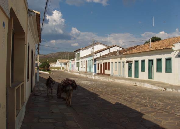
5. Mucugê in Bahia

Founded at the end of the 18th century, Mucugê is one of the oldest towns in the Chapada Diamantina region, having been one of the country’s most important centres of gold and diamond mining.
Its historical heritage is well preserved in its colonial houses and buildings, surrounded by cobbled streets. One of the strong points of local tourism is the famous June Festivals, full of great attractions.

História de Mucugê na Bahia
The discovery of diamonds
Mucugê, one of the oldest towns in the Chapada Diamantina (founded in the 18th century), was the first town in Bahia where diamonds of real value were found.
The discovery of the deposits in 1844 was made by a prospector known as Cazuza do Prado, who found the first nuggets in the gravel of the Mucugê river.
Gold rush
After the discovery was announced, there was an unstoppable rush of thousands of people in search of the dream of quick riches.
By 1848, the population had grown to more than 30,000, most of them prospectors and traders. The town of Mucugê do Paraguaçu was born. Mining followed the course of the Contas and Paraguaçu rivers and expanded rapidly throughout the region.
Expansion of mining
Shortly afterwards, in 1845, the rich mines of the Lençóis River were discovered, immediately attracting the interest of diamond buyers from Mucugê.
Other prospectors, traders from the capital and plantation owners from the Recôncavo Baiano arrived with their slaves.
Elevation to town
In 1847 the village was separated from Rio de Contas and promoted to the category of town under the name of Vila Santa Isabel do Paraguaçu.
The town was renamed Mucugê in 1917, when it was promoted to the category of city. From 1871, like other diamond centres, the town’s economic importance began to decline due to competition from diamonds from South Africa.
New cultures
With the decline of diamond mining, sugar cane, cereals, cotton and coffee plantations developed on the right bank of the Contas River.
Cattle ranches developed on the right bank. A new source of income for the population was the collection and export of evergreens, a flower typical of the region and highly prized on the market.
Architectural heritage
The architectural and landscape ensemble of Mucugê, especially the town’s cemetery, was declared a National Heritage Site by IPHAN in 1980.
The heritage consists of single-storey houses and townhouses dating from the second half of the 19th century, and two churches, the parish church of Santa Isabel and the church of Santo Antônio.
The urban architectural collection consists of 300 one-storey houses and 10 sobrados, most of which are used exclusively for residential purposes. The colonial architecture is well conserved.
Natural beauty
The Portuguese-style houses, dating from the second half of the 19th century, are mostly built of adobe or stone.
The city’s streets are very clean and its gardens and flower beds are very colourful.
In addition to the breathtaking beauty of the local landscape, marked by waterfalls, valleys and canyons, the city’s cultural heritage is enriched by the stories of the struggles for possession of the gold mines, against the invasion of the Prestes Column and the Colonels.
One of the natural attractions is the Alto do Capa Bode, considered a place of contemplation, where locals and visitors claim to have seen unidentified flying objects (UFOs).

Historical places of interest in Mucugê
- Santa Isabel Cemetery: Located between the historic centre and the rocky mountainside, it is characterised by a group of mausoleums that reproduce miniature facades of whitewashed churches and chapels – earning it the name ‘Byzantine Cemetery’. Construction began in 1854 by the city council. It was completed in 1886, when an epidemic struck the city.
- Igreja Matriz de Santa Isabel: Built in the mid-19th century by Brother Caetano de Troyria, with the help of the local population, on land donated by Colonel Reginaldo Landulpho. It has a neoclassical façade with three naves and a U-shaped choir. It was completely restored by Iphan in 2014.
- Santo Antônio Church: It was restored by Iphan in 2012 and is now completely revitalised.
- Museum and Public Archive: Created in 1996, it preserves the regional memory with a rich collection of everyday life from the diamond mining era.
- Garimpo Living Museum: Housed in a “pit”, the former home of the gold miners, it contains an exhibition of mining tools and a replica of the largest diamond found in the world.
- Sempre-Viva Project: Created with the aim of preserving the Sempre-Viva, a flower endemic to the region and threatened with extinction. It carries out activities of environmental education, flora protection, geo-processing and mapping, as well as research in partnership with the State University of Feira de Santana.


6. Rio de Contas in Bahia

The architectural complex of Rio de Contas is considered one of the most important in Bahia, with beautiful colonial mansions and cobbled streets.
Formerly known as Pouso dos Creoulos, the town served as an escape route for slaves at the end of the 17th century.
This period is well preserved in the local Public Collection, which contains various letters of release, ecclesiastical judgements and original slave certificates.
Another attraction is the stone road of the Estrada Rural, which was used to transport the region’s gold.
História de Rio de Contas na Bahia
Foundation
At the end of the 17th century, travellers from Goiás and the north of Minas Gerais, on their way to Salvador, founded the town of Creoulos as a landing place.
The discovery of gold in the Brumado Riverbed attracted a large number of prospectors to the region, who travelled upstream and founded the settlement of Mato Grosso.
Growth through mining
The city grew as a result of mining. In 1718, the Parish of Santo Antônio de Mato Grosso was created, the first in the Alto Sertão Baiano.
At the beginning of the 18th century, the Jesuits built a church 12 kilometres below the village of Creoulos, dedicated to Nossa Senhora do Livramento.
Foundation of the town
In 1724, Viceroy Dom Vasco Fernandes commissioned Colonel Pedro Barbosa Leal to found a town on the upper Sertão Baiano.
The site chosen was Sítio, 12 kilometres below the village of Creoulos, and the town was called Nossa Senhora do Livramento do Rio de Contas.
Viceroy Dom André de Melo e Castro, Count of Galvêas, ordered the town’s headquarters to be moved to the village of Creoulos, now the town of Rio de Contas, in 1745. The name of the town was taken from the name of the river that ran through the municipality.
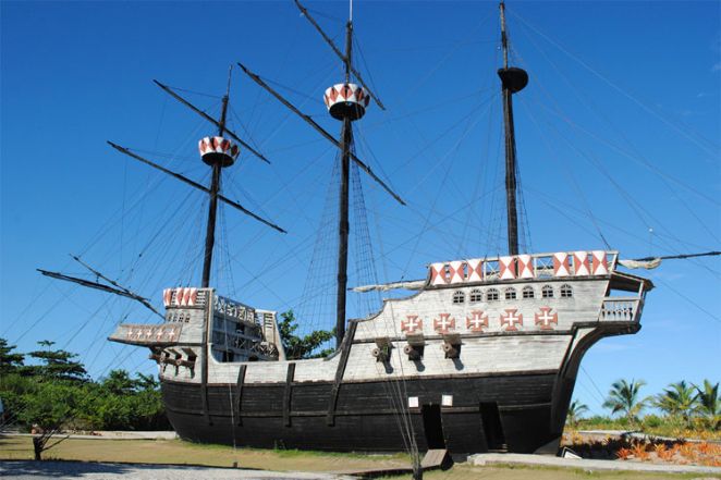
7. Porto Seguro in Bahia

History tells us that the colonisation of the country began here.
To this day, its streets retain evidence of the Discovery, including the ruins of the first church and the first school built on Tupiniquin land.
Many of the old buildings remain, especially on the Discovery Coast, which includes the region of Santa Cruz Cabrália – where the country’s first mass is said to have been held.
Local tourism is boosted by high school graduation trips.
História de Porto Seguro
Origins
The origins of the current municipality of Porto Seguro are linked to the early chapters of Brazil’s history.
Its territory is home to the first piece of land discovered by the ships of Admiral Pedro Álvares Cabral – Monte Pascoal. The first point discovered, on 22 April 1500, was Porto Seguro.
Settlement
The settlement of the present city began in 1626, in the area now known as the “upper town”, when a trading post was established by Cristóvão Jacques to guard the coast.
The colonisation was carried out by the Portuguese and the priests of the Society of Jesus.
The captaincy of Porto Seguro was granted by Royal Charter on 27 May 1534 to Pero de Campos Tourinho, its first grantee, who built the town in 1535 at the mouth of the Buranhém River: He built houses, a fort, a chapel, warehouses, a shipyard and a forge, distributed land to the inhabitants, created a register of sesmarias and began to explore the hinterland.
Second donor
The second grantor was Fernão de Campos Tourinho, son of Pero, who managed it badly and suffered attacks from the Aimoré. After his death, his sister succeeded him, and on 10 August 1559 she sold the captaincy to João de Lencastro, 1st Duke of Aveiro.
He later bequeathed it to his son, Pedro Diniz. In 1759 the Captaincy of Porto Seguro passed to the Crown and later became part of the Province of Bahia.
8. Valença in Bahia

Considered the starting point for a visit to Morro de São Paulo, this small town in Bahia has its charms.
In the historic centre of Valença, colourful houses and buildings from the colonial period are well preserved. Its uneven cobbled streets add to the sense of nostalgia, enhanced by the small churches around them.
Hereditary Captainships
During the colonial period, when Brazil was divided by the system of hereditary captaincies, the territory of the parish of Valença belonged to the captaincy of São Jorge dos Ilhéus and administratively to the town of Nossa Senhora do Rosário de Cairu.

First settlers
The place was inhabited by peaceful Tupiniquin Indians, and history tells us that the first settlers arrived between 1557 and 1571, when Mem de Sá was governor-general of Brazil.
Among these settlers was Sebastião de Pontes, a wealthy and influential man who already owned two sugar mills in the Recôncavo region of Bahia.
Conflict and decline
When he arrived, he built a corral facing the island of Tinharé and a sugar mill, the latter two leagues from the mouth of the Una River.
Dwellings, a purification house and a church with three vaulted chapels were also built, possibly attracting other inhabitants and sugar cane farmers to settle nearby.
There was also a village of Indians nearby, who were subordinated to Sebastião de Pontes.
With a violent temperament, he committed acts that cost him severe punishments, and he had to return to Portugal and end his days in prison.
Colonisation resumes
With the departure of Sebastião de Pontes, the settlement began to suffer constant attacks from the violent Aimoré Indians and a process of decay. As a result, the colonisation of Valença stagnated for a long time.
It wasn’t until the 18th century that the São Paulo Bandeirante João Amaro Maciel Parante began to crack down on the Aimorés.
Creation of the city
The new momentum of development that resulted from this action led the General Ombudsman of the district of Ilhéus, Baltazar da Silva Lisboa, to ask Portugal for the official creation of a new town in the village of Una.
The new administrative formation was granted and the town of Nova Valença do Sagrado Coração de Jesus was created, whose territory was separated from Cairu by the signing of a Royal Charter in January 1779.
Establishment of the town
It wasn’t long before the village of Nova Valença do Sagrado Coração de Jesus was officially founded on 10 June of that year.
With the establishment of the new town came the construction of the Church of the Sacred Heart of Jesus, built as a parish church. It was consecrated on 26 September 1801.
Development into a town
The village of Nova Valença do Sagrado Coração de Jesus developed and, on 10 October 1849, by virtue of Resolution 368, it was granted the status of a city and renamed the Industrial City of Valença.
9. São Cristóvão in Sergipe

Founded in 1590, the city is one of the oldest in the country and was the state capital until 1855.
Situated on the outskirts of Aracaju, São Cristóvão has a rich and well-preserved colonial architectural complex with a Spanish influence, which characterises the charming Historic Centre.
Its attractions delight tourists, especially the Praça de São Francisco – declared a UNESCO World Heritage Site in 2010.
História de São Cristóvão em Sergipe
Founder and first capital
São Cristóvão is the fourth oldest city in the country and was the first capital of Sergipe. It was founded in 1590 by Cristóvão de Barros.
The city underwent several changes until it settled where it is today, on the banks of the Paramopama River, a tributary of the Vaza-Barris River.
Invasions and destruction
In 1637 the city was invaded and virtually destroyed by the Dutch. The Luso-Spanish troops, under the command of the Count of Bagnoli, trying to avoid supplying the enemy, set fire to the crops, scattered the cattle and called on the population to desert.
The Dutch, finding the city half deserted, completed the work of destruction.
Reconstruction
In 1645, the Dutch were expelled from the captaincy of Sergipe, leaving the city in ruins.
At the end of the 18th century, Sergipe was annexed to Bahia and São Cristóvão became the seat of an ombudsman. In 1710 it was invaded by the inhabitants of Vila Nova, to the north of Sergipe, who were angry at the taxes imposed by Portugal. The city was completely rebuilt in the middle of the 18th century.
Emancipation
On 8 July 1820, by decree of Dom João VI, Sergipe was emancipated from Bahia and made a province of the Empire of Brazil, with São Cristóvão as its capital.
At the end of the first half of the century, the mill owners led a movement to move the capital to another region where there was a port capable of receiving larger ships to facilitate the flow of sugar production, the main source of the economy at the time.
Transfer of the capital
On 17 March 1855, the provincial president at the time, Inácio Joaquim Barbosa, transferred the capital to Aracaju.
From then on, the city went through a process of depopulation and crisis, which was only resolved at the beginning of the 20th century with the arrival of the textile factories and the railway.
10. Laranjeiras in Sergipe

The city’s architectural complex includes many baroque buildings, especially churches such as Nossa Senhora da Conceição da Comandaroba.
During the colonial period, the region was considered one of the country’s most important slave trading centres – a sad story told in the Afro-Brazilian Museum.
One of the great attractions of local tourism are the folklore festivals that fill the streets and entertain visitors.
História e monumentos de Laranjeiras em Sergipe
Historical importance
The municipality of Laranjeiras, 18 kilometres from Aracaju, is one of the few where you can still see the strength of colonial architecture. Streets, houses, churches, everything breathes history.
Laranjeiras was once the most important city in Sergipe, the cradle of culture, education, politics and economy.
Founders and development
The only reason it didn’t become the capital of Sergipe was a political manoeuvre by the Baron of Maruim, who moved the headquarters from São Cristóvão to Aracaju.
After Cristóvão de Barros‘s troops wiped out the indigenous peoples around 1530, many settlers ended up on the banks of the Cotinguiba River. These lands belonged to the Parish of Socorro.
Growth of the village
A small harbour was built in the area, about a mile from the town centre, and because of the many leafy orange trees by the river, locals and travellers began to refer to the place as the Orange Port.
Movement along the Cotinguiba River was intense and the port soon became an obligatory stop. Trade, especially the exchange of slaves, flourished around it, and the first houses were built.
Conflict and recovery
But from 1637, the small town of Laranjeiras also suffered attacks and then Dutch rule.
Many houses were destroyed, but the port, a strategic point, was preserved. It wasn’t until 1645 that the Dutch left Sergipe.
Development after the domination
The Harbour of Laranjeiras brought progress to the town, which rebuilt itself with great speed after the passage of the Dutch. In 1701, the Jesuit priests built the first church with a convent.
It was built on the left bank of the São Pedro Creek, not far from the harbour. They were looking for peace and quiet and named the place Retiro.
Historic buildings
The Jesuits built another church on one of the highest points in the village.
In 1731, the priests had the Church of Our Lady of the Conception of Comandaroba built on a hill, a true masterpiece of colonial architecture.
Thanks to sugar cane, coconuts, cattle, trade and above all the port, the town of Laranjeiras had reached an extraordinary level of development.
Political evolution
Even the inhabitants of the Parish of Socorro, to which Laranjeiras belonged, used to go to Laranjeiras every week.
It wasn’t until 7 August 1832 that the General Assembly of the Province took a controversial decision, due to the strong political influence of landowners and merchants.
It turned the village into an independent town. Instead of separating it from the parish of Socorro, the deputies annexed the territory of Nossa Senhora do Socorro to that of Vila de Laranjeiras.
Political conflicts
The people of Socorro tried in every way to resist, and on 19 February 1835 Socorro was transformed into a city, its lands separated from those of Laranjeiras, which was reduced to the Parish of the Sacred Heart of Jesus of Laranjeiras.
This setback did not stop progress, however, and it was at this time that Laranjeiras began to reach its highest level of development.
On 6 February of that year it became a district of Peace, and on 11 August 1841 Laranjeiras became the seat of a district. The first magistrate was Manoel Felipe Monteiro.
11. São Luís in Maranhão

The state capital differs from most Brazilian cities in that it was colonised by the French.
In the 17th century, sailors from Cancale and Saint-Malo settled in the region and named it after King Louis XIII.
At that time the economy was based on the cultivation and export of sugar cane, cocoa and tobacco.
Today, the main legacy of these people, together with the Portuguese and Dutch, is preserved in the Historic Centre, with several buildings that hark back to the past.


Founding
The city of São Luís, the capital of Maranhão, was built on the Peninsula overlooking the estuary of the Anil and Bacanga rivers.
It was founded on the 8th September 1612 by the Frenchmen Daniel de La Touche and François de Rasilly, whose common goal was to create Equinoctial France in the context of the mercantilist economy.
In honour of the then King of France, Louis XIII, the capital of Maranhão finds the roots of its name: São Luís.
Conquest and domination
Conquered by the French and brought under Portuguese rule just three years after its foundation (1615), the city of São Luís succumbed to Dutch rule during the 17th century.
However, as with the French, the Dutch were defeated in a war by the Portuguese and expelled three years after the invasion, in 1645.
Portuguese colonisation
This was the beginning of the Portuguese colonisation of the former Upaon Açu or Ilha Grande, according to the Tupinambá name for the island of São Luís.
Born by the sea and characterised as a river and sea port, like other Brazilian cities of the colonial era, the capital of Maranhão played an important role in the economic production of colonial Brazil during the 17th and 19th centuries, being considered the fourth largest cotton and rice exporting centre, after Salvador, Recife and Rio de Janeiro.
Urban development
The civil urban complex that makes up the Historic Centre of the capital of Maranhão dates from this period and is one of the most representative and richest examples of the urban layout and architectural typology produced by Portuguese colonisation.
In fact, the architectural typology that corresponds to the 18th and 19th centuries is very different from the rammed earth and wooden houses that characterise the civil buildings of the 17th century: they are solid constructions made of stone masonry and mortar with fish oil, metalwork and lias stonework of European origin and hardwood.
Remarkable architecture
In any case, the most representative examples of architecture in São Luís date mainly from the second half of the 19th century. These are the sobrados, with facades covered in Portuguese tiles, which are one of the most peculiar aspects of Maranhão’s civil expression.
12. Alcântara in Maranhão

Its nickname, the City that has stood still in time, lives up to its identity. Many of its colonial buildings lie in ruins, such as the Church of São Matias.
Around the 18th century, the region experienced its heyday thanks to the planting and trade of sugar cane and cotton. Buildings from this period are still well preserved and testify to the wealth of the barons who lived here.

Alcântara no Maranhão
Foundation
It is not possible to say exactly when Alcântara was founded, but it is certain that in 1612 there was already a group of villages to which it belonged, with the significant name of Tapuitapera (Land of the Indians).
With the arrival of the expedition of Daniel de La Touche, Lord of La Lavadière, and the constant infiltration of the French among the native tribes, friendly relations were established with them. Shortly afterwards, the first Alcantarense was baptised with the name of Martinho Francisco.
A chapel was built in his taba, and it is said that the first mass in Alcântara was celebrated there.

Portuguese rule
After the expulsion of the French, Portuguese rule was established, but the importance of the village was not diminished.
Between 1616 and 1618, Portuguese colonisation began in Tapuitapera, with a small prison that was later destroyed by the Indians.
With the division of the captaincies of Maranhão and Grão-Pará, Tapuitapera became the head of the captaincy of Cumã, which was donated by the 1st governor of Maranhão, Francisco Coelho de Carvalho, to his brother, Antônio Coelho de Carvalho, on 19 March 1624.
Development of the city
However, it doesn’t seem that the grant gave the captaincy a rapid development, as it was abandoned in 1641, at the time of the Dutch invasion, after a short period of occupation.
The village’s progress did not begin until 1648, when it was elevated to the category of city, with the name of Alcântara, under the invocation of the apostle St Matthias. At this time, there was already a stone and limestone church dedicated to St Bartholomew, and the first sugar mills had already been built.

Growth and education
Soon after the city was founded, construction began on the Nossa Senhora dos Remédios Convent, later renamed Nossa Senhora das Mercês, and then the Nossa Senhora do Carmo Convent, also a major undertaking.
Alcântara gradually prospered in all sectors and became the largest manufacturing centre in the province, where the great fortunes of the time were to be found. What undoubtedly contributed to its wealth was the large number of slaves.
Education and culture
It became customary for wealthy families to send their children to Coimbra for education, as the city had only primary schools, and this practice continued for many years.
This was partly due to the large number of families of Portuguese settlers, most of them of noble descent. Later, with the creation of the Legal Course in Brazil, Olinda replaced Coimbra.
Recognition and decline
In 1835 the Comarca was created and its first magistrate was Clóvis Bevilacqua. It was promoted to town in 1836, when it was at the height of its splendour.
Gradually, however, Alcântara lost its primacy in Maranhão’s production, and the decline of its economic activities was reflected in its social life. On 22 December 1948, the third centenary of its city status, Alcântara was declared a National Monument.
Publicações Relacionadas
José Américo de Almeida left Paraíba to revolutionize northeastern literature
History of the introduction of Portuguese tiles in Brazil
Fine Arts in the Brazilian Northeast
Biografia de Jorge Amado
Geography and Climatic Regions of the Brazilian Northeast
São Jorge dos Erasmos Sugar Mill: A Landmark in Brazil
Why go to the Brazilian Northeast?
Influences and main dishes of northeastern cuisine
Maranhão's handicrafts have more than 400 years of tradition
History of the Brazilian Northeast
Rapadura continues in the daily life of the northeasterner to this day
Northeastern architecture marked by typical features of colonial structures
Casa Grande & Senzala: The Work of Gilberto Freyre
History of Carnival in Northeast Brazil
The influence of Arab architecture on the buildings of Pernambuco
Tropical flowers are grown on a large scale in northeastern Brazil
History and origin of Northeastern literature and biography of the main authors
Music and Rhythms of the Brazilian Northeast
This post is also on:
![]() Português
Português ![]() English
English ![]() Deutsch
Deutsch ![]() Español
Español ![]() Français
Français


