Lavras da Mangabeira and the Salgado River Canyon in Ceará: An ecotourism and cultural destination
The State of Ceará is home to a remarkable Canyon of the Salgado River, located near the city of Lavras da Mangabeira.
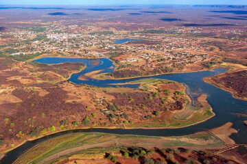
This canyon, also known as the Boqueirão, belongs to the municipality of Lavras da Mangabeira and is characterised by its imposing rocky walls cut by the main tributary of southern Ceará, the Boqueirão.
With great potential for ecotourism, the site has attracted the attention of adventurers and tourists.

Features of the Salgado River Canyon
The Rio Salgado Canyon, often called the Boqueirão do Rio Salgado, Boqueirão de Lavras or simply the Boqueirão, has a width of up to 44 metres and a rock height of up to 109 metres in certain sections.

Cânion no Rio Salgado no Ceará
The name “boqueirão” derives from the appearance of the canyon, which resembles a large mouth, and is a geographical term used to describe a gorge-like opening in geographical features such as mountains and plateaus.

Leisure activities
Since 2020, the canyon has offered activities such as abseiling and kayaking, making it even more attractive to tourists.
Lavras da Mangabeira
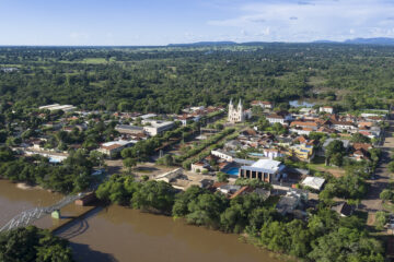
Lavras da Mangabeira is a Brazilian municipality, located in the microregion of Lavras da Mangabeira, in the Middle-South mesoregion of Ceará.

The city is part of the Ceari Metropolitan Region and is known for its rich biodiversity and stunning landscapes.
Natural attractions
The Rio Salgado Canyon has been described as an “open gorge” 109 metres high in relation to the water level, and is one of the most impressive landscapes in the Cariri region.
Despite its beauty, the site is still relatively unknown in the south of the State, especially when compared to the many natural riches of the Chapada do Araripe.
Geological Formation
Boqueirão, as it is popularly known, was created by the opening of a single rock, the result of a geological fault.
Geologist Yarley Brito explains that this rupture occurred “millions of years ago”, resulting in a wall close to the riverbed that is almost 44 metres wide and a permanent well.
History of Lavras da Mangabeira
The lands around the Salgado River were first inhabited by various indigenous ethnic groups, especially the Kariris. In the 17th century, with the final occupation of Ceará, several entradas brought soldiers, explorers and religious (missionaries) who studied and catechised the indigenous people and organised them into villages.
The gold rush
These contacts led to the discovery of gold in the Mines of São José dos Cariris Novos (now Missão Velha). News of the discovery of gold sparked a veritable race for riches, attracting families from Portugal in search of wealth. This search for gold contributed to the colonisation of Cariri and the emergence of towns in the region.
Chapel of San Vincente Ferrer
In 1758, the Portuguese Crown stopped gold mining due to the high costs involved. During this period, the Chapel of São Vicente Ferrer was built on the site known as Boqueirão de Lavras, which became the basis for the creation of the new urban centre that became the town of Lavras da Mangabeira.

This post is also on:
![]() Português
Português ![]() English
English ![]() Deutsch
Deutsch ![]() Español
Español ![]() Français
Français


