Portuguese discoveries were the result of Portuguese maritime expansion, which marked the history of Portugal and the world.
Throughout the 15th century, the Portuguese transformed and perfected all known shipbuilding and navigation techniques.
Portuguese maritime expansion was an unprecedented development.
One gets the impression that if it took eighty years to reach the Cape of Good Hope, it took the Portuguese thirty years to reach Greenland, the Indies in 1498, Brazil in 1500, China in 1511 and Japan around 1548.
Between 1415 and 1492, Portugal was not only the pioneering nation, but also the sole navigator of the Atlantic Ocean. During this period, the Portuguese sailed around West Africa.
The conquest of Africa gave the Portuguese a range of spices: gold, pepper, nutmeg, ivory and slaves.
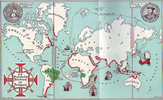
Descobrimentos Marítimos Portuguesas
CHRONOLOGY OF PORTUGUESE DISCOVERIES
- AUGUST 1415 – CONQUEST OF CEUTA
- JULY 1418 – DISCOVERY OF THE MADEIRA ARCHIPELAGO
- JANUARY 1427 – LANDING IN THE AZORES ARCHIPELAGO
- MAY 1434 – GIL EANES DOUBLES THE BOJADOR CABIN
- october 1437 – PORTUGUESE DEFEAT IN TANGER
- JANUARY 1444 – DISCOVERY AND CONQUEST OF GUINEA
- JANUARY 1450 – BIRTH OF BARTOLOMEU DIAS (1450?-1500)
- JANUARY 1456 – DISCOVERY OF CAPE VERDE
- OCTOBER 1458 – CONQUEST OF ALCÁCER CEGUER
- JANUARY 1467 – BIRTH OF PEDRO ÁLVARES CABRAL (1467?-1520?)
- JANUARY 1468 – BIRTH OF VASCO DA GAMA (1468-1525).
- AUGUST 1471 – CONQUEST OF ARZILA AND TÂNGER
- october 1492 – arrival of cristoforo colombo in america
- JUNE 1494 – SIGNING OF THE TORDESILLAS TREATY
- MAY 1498 – DISCOVERY OF THE SEA ROUTE TO INDIA
- APRIL 1500 – DISCOVERY OF BRAZIL
- SEPTEMBER 1507 – CONQUEST OF ORMUZ
- NOVEMBER 1510 – CONQUEST OF GOA
- AUGUST 1511 – CONQUEST OF MALACA
- MAY 1513 – PORTUGUESE ARRIVE IN CHINA
- AUGUST 1515 – ESTABLISHMENT OF THE PORTUGUESE IN TIMOR
- SEPTEMBER 1519 – FERNÃO DE MAGALHÃES (1480 – 1521) BEGINS HIS WORLD TOUR

1. CONQUEST OF CEUTA – AUGUST 1415
Around 20,000 men embarked from Lisbon and conquered the African city of Ceuta on 22 August 1415.

It was an important trading city in the Muslim Mediterranean world. War, economic and political reasons are given for this first step in what was to become Portugal’s expansion into Africa.
2. DISCOVERY OF THE MADEIRA ARCHIPELAGO – JULY 1418
The date on which Gonçalo Zarco and Tristão Vaz Teixeira landed on the island of Porto Santo is uncertain.

It is known that they left there in July 1418 to land on the island of Madeira, a land of which there were reports before the arrival of the Portuguese.
3. LANDING IN THE AZORES ARCHIPELAGO
At an uncertain date, Diogo de Silves sailed to the islands on the orders of the Infante D. Pedro. In the years that followed, new expeditions were made to other islands in the archipelago.
As in the case of Madeira and Porto Santo, the Azores were not completely unknown, as there are reports of their existence before the arrival of the Portuguese.
4. GIL EANES DOUBLES CAPE BOJADOR – MAY 1434
It is known that in May Gil Eanes set out to double Cape Bojador, also known as Cape Fear.
As he got closer to his goal, he decided to go off the coast and managed to get past it. Many popular legends claim that the world ended there.
The passage of Cape Bojador
Cape Bojador, on the coast of Western Sahara, was known as the Cape of Fear. Sharp-edged reefs dominate the region, making navigation very risky.
25 kilometres off the coast of the Cape, in the open sea, the depth is only 2 metres.
The height of the waves, the frequency of storms, the violence of the winds, the lack of knowledge of ocean currents and the permanent fog made navigation extremely dangerous.
Those who crossed never returned. Legends tell of more than 12,000 failed attempts.
Some believed that from then on the winds blew south, preventing them from returning to Portugal and heading north.
Others thought it was the end of the world, and that the fog was the result of the evaporation of the water, which boiled as it fell into the hell below. Legends told of sea monsters and gigantic, ferocious whirlpools.
The sea boiled in the heat, and only certain bizarre creatures could survive the intense heat and dryness. There were tales of great treasures guarded by ferocious dragons and giants that would enter the sea and destroy ships.
Imaginative tales of abandoned and returned crews fuelled the legends. Cape Bojador was thought to be insurmountable, the end of the known world.
5. PORTUGUESE DEFEAT IN TANGER – OCTOBER 1437
Outnumbered and disorganised, the Portuguese attacked the square in Tangier.

The troops are surrounded and surrender. After negotiations, the Portuguese forces are allowed to leave, but the Muslims demand the surrender of Ceuta in return. To guarantee the agreement, Prince Ferdinand was taken hostage.
The Infante, who had made the deal, backed down after his release. Prince Ferdinand died in captivity in Fez in 1443.
6. DISCOVERY AND CONQUEST OF GUINEA – JANUARY 1444
Guinea was a generic name given to the black Africa that stretched south of Cape Bojador.
After the Portuguese defeat at Tangier, there was a commitment to overseas expansion in order to get closer to raw materials.
7. BARTOLOMEU DIAS BORN (1450?-1500) – JANUARY 1450
He was the first European to circumnavigate the Cape of Storms, later named the Cape of Good Hope, in 1488.
The voyage of Bartolomeu Dias changed the name of the dangerous Cape to Good Hope, opening the passage to the sea route to India.
Bartolomeu Dias was a skilled and experienced navigator. He was entrusted with various missions. He died when his caravel sank off the Cape of Good Hope in 1500.
8. DISCOVERY OF CAPE VERDE – JANUARY 1456
The date of the discovery of the archipelago is disputed, as is the name of the navigator who first arrived there.
Diogo Gomes, Alvise Cadamosto or António da Noli have been mentioned as possible discoverers, all in the service of Prince Henry the Navigator.
9. CONQUEST OF ALCÁCER CEGUER – OCTOBER 1458
The conquest was led by King Afonso V. The square was conquered, but its maintenance was always very difficult. It lost its importance and was abandoned in 1550, when Portugal had already conquered Tanger and Arzila.
The town of Alcácer-Ceguer, or Al Qasr al saghir, which means ‘little castle’, is located on the coast of northern Morocco, between Ceuta and Tangier.

Although it lacked the importance of these two cities, in the 15th century it was a position of some importance as a base for shipping and a stronghold for corsairs from the Straits of Gibraltar.
On 24 October 1458, the King of Portugal entered the town after the inhabitants had surrendered to the Portuguese troops who had landed three days earlier and whose artillery had managed to break through the walls.
In fact, Alcácer-Ceguer didn’t have enough troops or fortifications to withstand the onslaught of the Portuguese Armada, which consisted of two hundred sailing ships, artillery and several thousand soldiers.
The expedition was led by the monarch himself and included some of the most important figures of the Portuguese nobility, including Prince Henry the Navigator, who played an important role in its preparation.
What were the reasons that led the king to prepare the expedition?
The conquest of Alcácer-Ceguer was a kind of “return to Morocco” after the failure of Tangier two decades earlier. It was, of course, only possible after the accession to the throne of King Afonso V, who had been keen to resume his projects of conquest in North Africa. Several circumstances favoured the return of the Portuguese to Morocco at this time.
Firstly, Ceuta was the only Portuguese outpost in North Africa, and its isolation had limited its usefulness and effectiveness. Secondly, the Pope had recently issued a crusade bull granting Portugal possession of Alcácer-Ceguer.
Finally, and perhaps most importantly, the conquest of Constantinople by the Ottoman Turks in 1453 caused a stir throughout Christian Europe and led the Pope to preach a new crusade, to which King Afonso V seems to have been the only monarch to respond in the affirmative.
Since this never happened, the king decided to channel resources into a military offensive in Morocco.
What was the significance of this conquest?
The capture of Alcácer-Ceguer signalled the definitive revival of Portuguese interest in Morocco. After conquering the small town, King Afonso V, inspired by dreams of the Crusades and feats of arms, went on to conquer Tangier and Arzila.
His son, João II, focused on the southern regions, where local produce was of interest to Portuguese trade along the African coast. Finally, D. Manuel extended the protectorate regime to various coastal regions of Morocco, integrating the Portuguese presence into his global crusading project.
However, maintaining the Portuguese plazas in North Africa was costly and difficult, especially as they became less and less useful.
For this reason, after his accession to the throne in 1521, King João III began to consider the possibility of evacuating some of the plazas, which happened in the following decades.
Alcácer-Ceguer was abandoned in 1549, leaving only Ceuta, Tangier and Mazagan as the last landmarks of Portuguese expansion in Morocco.
10. PEDRO ÁLVARES CABRAL (1467?-1520?) BORN – JANUARY 1467
He commanded the squadron of 13 ships that discovered Brazil in 1500.
It was the second mission to India, but there was a deviation in the route that took the fleet to the Brazilian coast.
Very little is known about his life and it wasn’t until the 20th century that his tomb was discovered. Brazil would not become important in the Portuguese Empire until long after his death.
11. VASCO DA GAMA (1468-1525) born – JANUARY 1468
He commanded the fleet that discovered the sea route to India. The squadron of three ships took about 10 months to sail from Lisbon to Calicut.
He was the son of a nobleman and a member of the Order of St James. He was appointed Governor of India and died in Coxim.
In the 15th century, Portugal began its voyages of discovery. It first conquered Ceuta and other African centres and then set out to explore the coast as far as the Cape of Good Hope and India.
Vasco da Gama was in charge of this last voyage, leading a squadron of four ships that took about 10 months to reach Calicut.
The conquest of Ceuta was the first step towards the discoveries made by the Portuguese in the 15th and 16th centuries.
The possibility of reaching India became real in the second half of the 15th century, after Portuguese navigators sailed down the Atlantic coast of Africa and Bartolomeu Dias crossed the Cape of Good Hope.
Vasco da Gama, born in Sines and son of Estevão da Gama, was the man chosen to command the fleet that sailed to discover the sea route to India.
The fleet left on 8 July 1497 and arrived in Calecutta in May 1498, under the command of Vasco da Gama, a nobleman born in Sines.
The passage of the Cape of Good Hope the previous year had opened the door to the Indian Ocean for the Portuguese.
The voyage opened up a new trade route between Europe and Asia.
12. CONQUEST OF ARZILA AND TANGER – AUGUST 1471
Around 400 ships took part in the attack on the Arzila square in North Africa.
Despite many difficulties, the attack was decisive and the city was sacked. Several defenders and inhabitants of Muslim origin were killed after taking refuge in the mosque and the castle. Frightened, the defenders of the neighbouring square of Tangier abandoned their defences and King Afonso V sent a force that succeeded. Afonso V sent a force that managed to take the fortress.
There are still some traces of the Portuguese occupation of Arzila, a Moroccan town on the Atlantic coast, which was taken by the troops of King Afonso V in 1471. This video reconstructs the Portuguese invasion and the battles that took place there.
The conquest of Arzila was part of Portugal’s overseas expansion policy and took place in the second half of the 15th century, after the disaster of the operation in Tangier, where many Portuguese, including Prince Fernando, were taken prisoner.
It was clear that the conquest of places in Morocco was an indispensable lever for maritime expansion, and in the case of Arzila, the task was made easier by the fact that the Muslims were fighting each other. Nevertheless, as this video shows, the fighting was fierce and not without casualties.
Located on the northern coast of Morocco, the town was a Portuguese possession between 1471 and 1550, and later between 1577 and 1589.
The Portuguese Crown sent several Spanish Jewish families to Arzila to colonise it and signed a twenty-year peace treaty with the nearby Moors. Although few, there are still some traces of the Portuguese presence, including the keep of the fortress, the restoration of which was supported by the Calouste Gulbenkian Foundation.
13. CRISTOVÃO COLOMBO ARRIVES IN AMERICA – OCTOBER 1492
Leaving from the city of Palos in southern Spain, the ships commanded by Columbus sighted land after several months and landed on what is now the island of San Salvador in the Bahamas.

He continued on to Cuba. He returned to Spain convinced that he had reached Japan.

14. SIGNING OF THE TORDESILLAS TREATY – JUNE 1494
The Treaty of Tordesillas, signed in the Spanish town of Tordesillas, divided the ‘discovered and undiscovered’ world into two parts, with Portugal and Spain having the right to exploit each part.
The Treaty of Tordesillas, signed in the Spanish town of the same name, divided the ‘discovered and undiscovered’ world into two parts, with the rights to exploit each part going to Portugal and Spain.
The Treaty of Tordesillas was signed in the Spanish town of Tordesillas on 7 June 1494, about a year and a half after Christopher Columbus’s voyage to America.

According to Portuguese geographers, the coordinates provided by Columbus showed that the land he had discovered belonged to Portugal.
The Spanish crown asked for papal intervention to settle the matter.
Pope Alexander VI issued a bull establishing a meridional line dividing the planet in two, with the rights of exploitation of each part going to the Iberian countries, but King João II did not agree.
New negotiations began between the Catholic kings and the Portuguese monarch, resulting in the Treaty of Tordesillas.
15. DISCOVERY OF THE SEA ROUTE TO INDIA – MAY 1498
It took Vasco da Gama’s fleet 10 months to sail from Lisbon to Calicut in 1498. The door was open to trade with the Orient, which passed into Portuguese hands after centuries of control by the Muslim world.

In 1497, the fleet commanded by Vasco da Gama set sail from Lisbon to discover the sea route to India.
There were about 150 men on three ships – the S. Gabriel, the S. Rafael and the Bérrio – and a small port ship with supplies.
They left on 8 July 1497 and arrived in Calecut in May 1498.
The commander of this fleet, Vasco da Gama, was a nobleman born in Sines.
The passage of the Cape of Good Hope the previous year opened the door to the Indian Ocean for the Portuguese.
16. DISCOVERY OF BRAZIL – APRIL 1500
The ships commanded by Pedro Álvares Cabral were heading for India, but made a detour that brought them to the shores of Brazil in April 1500. The discovery was announced as an accident, but historians question this.

The fleet commanded by Pedro Álvares Cabral was on its way to India, but along the way it discovered Brazil. This discovery is sometimes described as accidental, but many historians disagree.
The second fleet to sail to India after the return of Vasco da Gama consisted of 13 ships and over 1000 men.
Before rounding the Cape of Good Hope, the commander of the fleet, Pedro Álvares Cabral, made a detour in the Atlantic that took him to the coast of Brazil, where he landed on 22 April 1500.
The discovery was announced as an accident, but many historians believe that the diversion was deliberate and that the Portuguese already knew the location of the New World.
17. CONQUEST OF THE ISLAND OF HORMUZ – SEPTEMBER 1507
The city of Hormuz controlled important trade routes.

Portugal first established diplomatic relations with the local king, but later Afonso de Albuquerque took the city.
A Portuguese fortress is built on the island of Hormuz, allowing Portugal to control the Persian Gulf and an important part of the trade between the East and Europe.
18. CONQUEST OF GOA – NOVEMBER 1510
Even before the arrival of the Portuguese, Goa was an important city on the Indian trade routes. Conquered by Afonso de Albuquerque in November 1510, it became the capital of the Portuguese Empire in the East.

Goa was an important Indian city on the main trade routes to the East. It was conquered by Afonso de Albuquerque and became the capital of the Portuguese Empire of India.
The city was only taken by Afonso de Albuquerque after two attempts and strong resistance from the Muslim forces that controlled the area.
After the conquest, in November 1510, the city grew and gained importance in the context of the Portuguese Empire, becoming its main port in the East.
By the end of the 16th century, the city had a population of around 250,000, a very large number even by European standards at the time.
Lost to the Indian Union in 1961, Goa still has an important heritage linking it to Portugal.

19. CONQUEST OF MALACCA – AUGUST 1511
The conquest of Malacca in August 1511 was also led by Afonso de Albuquerque, who commanded around 1,000 men and a dozen ships.
After the conquests of Hormuz and Goa, the aim of this operation was to consolidate Portuguese power in the East by creating a network of ports and squares to control access to the main trade routes.
20. PORTUGUESE ARRIVE IN CHINA – MAY 1513
The Portuguese Jorge Álvares is the first European navigator to reach China.

His ship landed on an island now known as Hong Kong in May 1513.
There is no certainty as to when this happened. The Portuguese presence grew in the following years, culminating in the establishment of a trading port in Macao in 1557.
21. ESTABLISHMENT OF THE PORTUGUESE IN TIMOR – AUGUST 1515
The first Portuguese fortress in Timor was built in 1515, but there was information about the territory before then.
The Portuguese presence on the island lasted until 1975, when the country was occupied by Indonesia. The territory only became independent in 1999.
22. FERNÃO DE MAGALHÃES (1480 – 1521) BEGINS HIS VOYAGE AROUND THE WORLD – SEPTEMBER 1519
Ferdinand Magellan was a Portuguese captain who offered his services to Spain. He left San Lucar de Barrameda in 1519 with five ships on a voyage around the world.
Only one of the ships returned to Spain in 1522. Magellan was one of those who didn’t. He died in battle on the island of Cebu in the Philippines. Of the 270 men who left Spain for the expedition, only 17 returned.
Publicações Relacionadas
Historical periods of Brazil - Colonial period to the New Republic
The Iberian Union and the Dutch invasion of colonial Brazil
Defences of Porto da Barra - Fortifications of Santa Maria and São Diogo
Chronology of slavery in colonial and imperial Brazil - History
History of Bahia in Colonisation, the Empire and the Republic
This post is also on:
![]() Português
Português ![]() English
English ![]() Deutsch
Deutsch ![]() Español
Español ![]() Français
Français


