Expansión marítima de Portugal: los portugueses en América del Norte

Los portugueses en América del Norte

La presencia portuguesa en América del Norte se remonta a los siglos XV y XVI, un período marcado por intensas exploraciones marítimas.

Motivados por la búsqueda de nuevas rutas comerciales y el deseo de ampliar sus conocimientos geográficos, los navegantes portugueses fueron pioneros en diversas zonas del continente.

En este texto, exploramos las principales expediciones realizadas por los portugueses en la región, destacando sus logros y sus importantes contribuciones a la historia de la exploración marítima.

Expansão Marítima de Portugal - Os Portugueses na América do Norte
play-rounded-fill

Portugal's Maritime Expansion - The Portuguese in North America

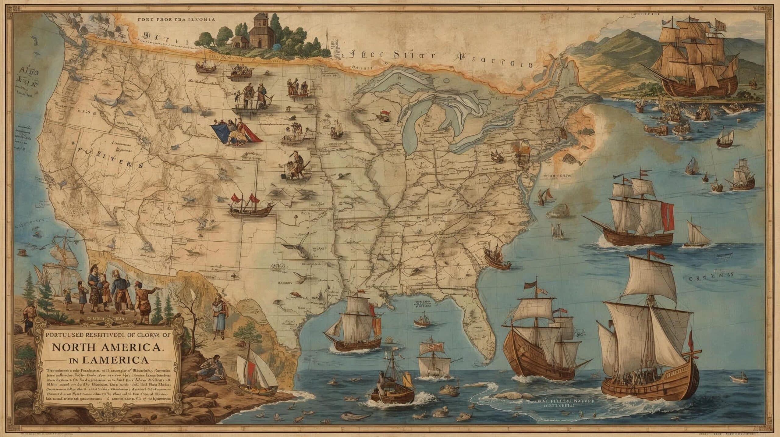
1. Exploraciones iniciales

Las exploraciones marítimas portuguesas también llegaron a América del Norte.

En 1474, João Vaz Côrte-Real y Álvaro Martins Homem fueron recompensados por sus viajes a la Tierra del Bacalao, que corresponde a la isla de Terranova, probablemente acompañados por navegantes daneses.

Hoy en día, la isla de Terranova se conoce como isla de Newfoundland, que forma parte de la provincia de Newfoundland y Labrador, en Canadá.

2. Viajes anteriores a Colón

A principios de 1492, antes que Cristóbal Colón, partieron el azoriano João Fernandes, conocido como Lavrador, y Pedro de Barcelos, en un viaje de tres años que los llevó a Groenlandia.

3. Cronología de las exploraciones portuguesas

  • 1474: João Vaz Côrte-Real y Álvaro Martins Homem son recompensados por sus viajes a la Tierra del Bacalao, la isla de Terranova o isla de Newfoundland.
  • 1492: João Fernandes y Pedro de Barcelos emprenden un viaje que los lleva a Groenlandia.
  • 1497: João Caboto realiza su expedición al servicio de Inglaterra, llegando a la costa de Terranova.
  • 1500: Gaspar Côrte-Real, autorizado por D. Manuel I, explora la región de Terranova y Labrador.
  • 1502: Gaspar Côrte-Real reanuda sus exploraciones, pero ni él ni su hermano Miguel regresan.
  • 1520: João Álvares Fagundes explora tierras de Canadá.
  • 1525: Estêvão Gomes visita las costas del noreste de los actuales Estados Unidos.
  • 1542: João Rodrigues Cabrilho descubre las costas de California, al servicio de España.

4. Gaspar Côrte-Real y sus exploraciones

En 1500, con la autorización de Manuel I, Gaspar Côrte-Real exploró la misma región, regresando al año siguiente y llegando a lo que hoy conocemos como Terranova y Labrador.

Las exploraciones se reanudaron en 1502, pero ni Gaspar ni su hermano Miguel regresaron.

5. Otras exploraciones portuguesas

Más tarde, otros navegantes portugueses también dejaron su huella en América del Norte.

João Álvares Fagundes exploró tierras de Canadá; Estêvão Gomes visitó las costas del noreste de los actuales Estados Unidos; y João Rodrigues Cabrilho, un portugués al servicio de España, descubrió las costas de California, en el océano Pacífico.

Esta serie de expediciones no solo amplió los conocimientos geográficos de la época, sino que también estableció vínculos duraderos entre Portugal y las tierras del Nuevo Mundo.

Map of North America from 1593 - This very rare map is the second printed map of the North American continent, following the smaller Forlani map of 1565. It was issued in Cornelis de Jode's Speculum Orbis Terrae in 1593, which was a revised edition of an earlier atlas published by his father Gerard in 1578. The present map was one of the several new engravings in Cornelis' work. While the atlas did not have much commercial success, de Jode's maps are often regarded as superior in both design and cartographic detail to his more successful competitor, Abraham Ortelius. Cartographically, the map is based upon Petrus Plancius' eighteen sheet world map of 1592 for the outline of North America. With only a few exceptions, the place names also directly follow Plancius' work. The map is notable for incorporating some of the concepts published in Theodore de Bry's Grand Voyages from 1590, including maps by John White and Jacques Le Moyne. Despite this new information, the Chesapeake Bay is placed too far north at a latitude equivalent to present-day Boston, while Virginia is north of C. de las Arenas (Cape Cod). These misplacements pushed the entire coastline too far to the north, and Norombega (New England) extends in an east-west direction between Chesepoc Sinus and the St. Lawrence River. To the north of the North American landmass is a prominent depiction of a Northwest Passage with a large mythical Lago de Conibas emptying into it. In the southwest, the seven cities of Cibola are situated next to an unnamed lake along with a note about Marcus Niza. The map is beautifully embellished with de Jode's distinct style, and is further decorated by a cartouche featuring six Virginia natives (per John White) and a vignette depicting the attack on Martin Frobisher's ship. Dedication to Theodor Echter at top left. There was only one edition of the Speculum produced, making this map quite rare on the market. The present example has a blank verso, and Burden notes that de Jode was selling this map both in the atlas and as a separate sheet. Wagner also states that examples occur without text. Publication: Speculum Orbis Terrae. The Second Printed Map of the North American Continent "Americae Pars Borealis, Florida, Baccalaos, Canada, Corterealis", Jode, Cornelis de
Mapa de América del Norte de 1593
Map of North America from 1574 Second state of Ruscelli's map based on Giacomo Gastaldi's map of 1548, which combined data from the Verrazano and Cartier voyages to create the first printed map devoted to the East Coast of North America. The nomenclature and cartography are unchanged, with the exception of the depiction of the Hudson and St. Lawrence Rivers (unnamed), which are shown connected upriver, a notion he borrowed from Ramusio. This is one of the first obtainable maps of the region and one of the first to name Bermuda. Engraved on copper by Giulio and Livio Sanuto in the unmistakable Italian style. "Tierra Nueva", Ruscelli, Girolamo. North America Period: 1574 (circa)
Mapa de América del Norte de 1574

Este post também está disponível em: Português English Deutsch Español Français

Hide picture